Sunday, July 31, 2022

Numerous Storms Yesterday


Catalinas before sunrise this morning above - at bottom is pre-dawn view of Orion over the Rincons.

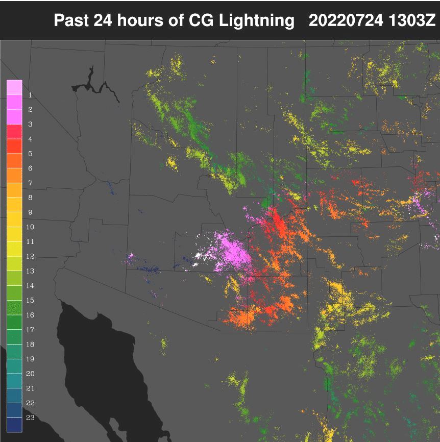
Yesterday was a very active storm day for all of Arizona. Plot of detected CG flashes for 24-hours ending at 0103 am MST this early morning (above, from Atmo and Vaisala) shows widespread thunderstorm activity across entire state. There were 9 reports of severe wind gusts in Arizona yesterday - 3 in Tucson area and 6 in Phoenix area (probably some others between here and there that were not reported).

ALERT data (above and below for 24-hours ending at 6:00 am) show nearly all sites had 0.04" or more yesterday, with quite a few reports of half an inch to more than an inch. Here at house we had 0.24" during a mid-afternoon storm; the airport reported 0.08"; DM had 0.50" with a near severe gust to 56 mph about 2:00 pm; and Atmo reported 0.15". It was quite a significant storm day for the entire metro area!


This morning the upper tropospheric anticyclone is centered about over Lubbock, Texas (as per 250 mb analysis above). There is a hint of a weak inverted trough to our east.

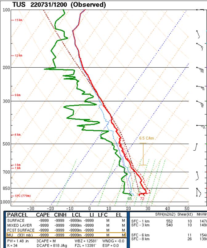
The 12 UTC TWC/TUS sounding (above) reflects the worked-over state of the atmosphere, after yesterday's activity. If I mix out BL to 700 mb, there appears to be little or no CAPE available for storms this afternoon. The 09 UTC run of the WRF-RR at Atmo somehow develops CAPE, and the forecast of precipitation through midnight is shown below. This, to me, appears to be too much storm activity over eastern Pima County, given that the day following an active event, as per yesterday's, is usually quite suppressed. 


Saturday, July 30, 2022


Some morning color over the city this morning at 5:51 am MST.

Thunderstorms were fairly isolated over all of southern Arizona yesterday. Plot of detected CG flashes for 24-hours ending at 01:03 am this morning (above, from Atmo and Vaisala) seems to indicate only a storm or two in eastern Pima County.

ALERT plots for 24-hours ending at 6:00 am this morning (above and below) show the scattered nature of yesterday's rains. I see only 4 reports over half an inch. Here at house I reported 0.14" during very early morning hours yesterday - during the day there was only an additional trace during a sprinkle or two.


The 06 UTC GEFS plumes for the airport (above) show that the operational GFS (blue) is a wet outlier, with quite heavy rains indicated for the airport this evening, as well as for rest of week. The 06 UTC run of the WRF-GFS (below, showing rainfall forecast through midnight tonight) is more conservative for the airport, but does forecast a band of heavy precipitation across Pima County to our west.

The morning forecast graphic from the NWS Forecast Office - second below - indicates highest chances for rainfall today extending from north of the Catalinas south across the metro area and Santa Cruz County. Should be another interesting weather day.


Friday, July 29, 2022

More Rain


Interesting view after sunrise this morning at 6:01 am MST, with illumination of the shallow haze layer between campus and the foothills. Bottom shows Wilcox sunrise at 5:42 am.

There were early morning showers with CG flashes on the Catalinas and Rincons - plot of detected CG flashes for 24-hours ending at 3:03 am this morning (above from Atmo and Vaisala).

ALERT plots (above and below) of 6-hour rainfall ending at 7:00 am. Significant coverage of amounts of 0.04" and greater.  Looks like a bogus report on Redington Pass of over four inches. Here at house we had 0.14" (after 0.18" yesterday morning); Atmo had 0.14; DM reported 0.09"; and the airport had 0.05".  


The 06 UTC WRF-GFS forecast from ATMO keeps much of metro area dry this afternoon - above shows precipitation forecast through midnight tonight. The average of the GEFS plumes however (below from 06 UTC runs) indicates about another 0.15" by midnight.

Wednesday, July 27, 2022

No Rain Here


 Views of Catalinas (above) and Rincons (bottom) at and just before sunrise, which was at 5:36 am MST today. The Rincon movie loops at Atmo show Orion the Hunter rising over the mountains just before dawn.

Plot above shows detected CG flashes for 24-hours ending at 0703 UTC today. However, the lack of afternoon/evening detections appears suspect to me. Observation remarks mention lightning through the afternoon and TUS carried thunder also. Perhaps the data feed went down?

Rainfall reports from the ALERT network for 24-hours ending at 7:00 am (above and below) indicate about 50 % of sites had 0.04" or more. About 20 sites reported amounts from a half to over an inch and a half. The airport and DM had thunder with 0.15" and Atmo reported 0.16" - nothing here at house, although there may have been thunder that I didn't hear.


The morning TWC/TUS sounding remains little changed again this morning - very moist, with considerable CAPE and light/variable winds. The TUS Forecast office has continued their flash flood watch through 5:00 am Friday morning.

There is a weak, upper-level cyclone centered south of the New Mexico Bootheel at 250 mb (above). This feature will continue to move slowly westward across northern Mexico and Arizona, providing some support for weak upward motion on the large scale.

Plumes for QPF at the airport (above - from the 06 UTC GEFS runs) indicate that the stormy/wet period will continue through the coming week. The 06 UTC WRF-GFS forecast for precipitation through midnight (below) shows a number of centers of heavy rainfall over eastern Pima and Santa Cruz Counties. Model again tries to hit the airport with a heavy storm and over an inch of rain. 

We will be away (near Sonoita) later today and tomorrow - will hopefully get some photos of heavy storms!


Tuesday, July 26, 2022

Storm Here Yesterday


Heavy storm over this part of town at 5:31 pm MST yesterday afternoon. Down at bottom is view of the Catalinas at 6:00 am this morning.

Plot of detected CG flashes (below - from Atmo and Vaisala) is for 24-hours ending at 3 minutes past midnight last night. There was a CG donut hole over much of the metro area, but overall there was widespread thunderstorm activity across most of Arizona and New Mexico.


Scattered reports of rainfall from the ALERT network (above and below, for 24-hours ending at 7:00 am this morning) with rain focused mostly on the west portion of the network. Thunderstorm here from around 5:00 to 6:00 pm left 0.33" in the gauge. Airport had thunder but only 0.07" of precipitation. There were 10 reports of half an inch or more, and two those exceeded an inch.


The 12 UTC 250 mb analysis (above) shows a weak and chaotic pattern over the Southwest. However, the large cyclone south of the Big Bend is forecast to move slowly westward the next couple of days bringing increased difluence over Arizona, which will help support large-scale vertical motion.

This morning's sounding (above) is similar to yesterday's, but with the winds aloft being mostly light and variable. The 06 UTC WRF-GFS forecast for rainfall through midnight (below) indicates a heavy storm to do a direct hit on the airport. Will be watching to see how today's storms actually evolve.

The NWS Flash Watch continues at least through today.


Monday, July 25, 2022

Significant Rains Yesterday


Heavy storms over the western Catalinas at 3:30 pm MST yesterday afternoon. Down at bottom is view at 6:26 am this morning.

Plot of detected CG flashes (above for 24-hours ending at 0753 UTC last night) shows a distinct donut hole over much of the metro area.

However, data from the ALERT network (above and below) shows that rains of at least 0.04" occurred at a high percentage of the sites. Note the very heavy amounts over the eastern Catalinas. The 4.92" at Pima Canyon near Table Mountain occurred between 2:30 and 4:30 pm. Here at house showers from 3:00 to 5:00 pm totaled 0.45" - making the total here for day 0.64". This was most rain since the event of 1 July. The airport reported thunder with gusts to 40 mph, but only 0.02".


This morning's TWC/TUS sounding (above) remains moist with a bit of CAPE. The winds are light southerly below 300 mb, with stronger east winds above that. Difficult forecast today - the shallow surface layer could heat out, producing a new but shallow BL that would have a significant cap - or, significant heating could mix the BL out to 700 mb, but there would then be little CAPE.

The WRF forecast runs are not consistent - some runs produce almost no rain in Pima County today; while other runs forecast heavy storms in the metro area during the evening and night.

 The NWS morning forecast (below) keeps POPs high with heavy rains and a Flash Flood Watch. I would lean toward a mostly down day, i.e., a typical scenario after widespread rains.


Sunday, July 24, 2022

Active Night


Thunderstorms occurred over much of the Tucson metro area during the late night and again before sunrise. Image above shows lightning over the Catalinas at 4:40 am MST. Photo below is of a morning rainbow taken from house at 5:45 am. Down at bottom is 5:40 am view to the west from downtown, showing a faint, secondary rainbow.


A fairly large MCS developed over southern Arizona by sunrise and moved off toward the Phoenix area. Satellite IR image of system (above at 6:18 am) from NCAR RAL. Below shows composite radar at 6:22 am - also from NCAR RAL.


Plot of detected CG flashes (above for 24-hours ending at 1303 UTC - from Atmo and Vaisala) indicates two periods of CG flashes over eastern Pima County - takes a close look to see this. Heavy storm activity indicated over Pinal County around sunrise. Some reports around Casa Grande were approaching 2 inches.

The ALERT plots for 24-hours ending at 6:00 am (below) show that about 80 percent of the sites recorded 0.04" or more rainfall. Note two reports over an inch off toward Redington Pass. Detailed time series plots (from both ALERT and MesoWest) indicate that many sites had rain before midnight and again during the early morning hours. For example: TUS reported 0.18" from 9:00 pm to 10:34 am and then .03" between 4:00 am and 6:00 am. Here at house we had 0.19" which all fell around 4:00 am to 5:30 am.


The morning sounding from TWC/TUS (above - from SPC) is quite moist, with some CAPE and mostly light and variable winds. Sounding was released during the early am rainy period and is likely not representative of the background environment. Would certainly be a good day for a special sounding around noon.

The 12 UTC run of the WRF-RR model forecasts only light showers today for most of the metro area (plot above shows rainfall through midnight tonight). Below is NWS Forecast Office current forecast for airport, indicating high POPs and a Flash Flood Watch in effect through next Tuesday. Quite an active period - will be interesting to watch what actually transpires.