Saturday, December 31, 2022

End Of 2022


Last sunrise of 2022 over the Rincons - with contrails.

Forecast of 500 mb level (from 12 UTC GFS this morning) indicating the western shortwave moving across the Four Corners region and extending southward past Baja.


The system brings precipitation across all of Arizona by noon on Monday (above, from 12 UTC WRF-RR forecast run at Atmo). Same run indicates that some of this may be snow along Highway 83 south of I-10 toward Sonoita.

More next year.

Friday, December 30, 2022

Morning Shower


Heavy cloud cover over the metro area at 7:30 am MST in this view toward the Rincons.

ALERT sites with 0.04" or more rain during past 24-hours (below). Heaviest amounts on Catalinas, where there was some more snow at high elevations. The airport, DM, and Atmo had traces, and we had 0.02" here that occurred a bit after midnight.


Morning statement from NWS above, with detailed forecast (below) for Sunday through Tuesday 2023. Second below shows this morning's 12 UTC WRF-RR forecast of precipitation through 2:00 am 2 January.


Thursday, December 29, 2022

Very Light Rains Yesterday


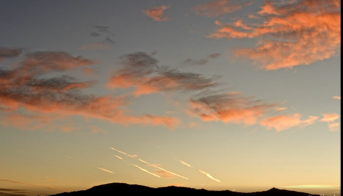
Pre-sunrise view of the Catalinas at 6:45 am MST this morning.

Yesterday's rainfall at low elevations was widespread, but quite light, as the forecast models were biased on the high side (see last couple of posts). Heaviest amounts (two sites with over half an inch) were from the Catalinas to Redington Pass. There were several inches of snow at higher elevations.

Here at house we had 0.09", Atmo and DM also had 0.09", and the airport reported 0.08". In Cochise county Pioneer Airfield had rain squalls with gusts to 59 mph and Ft. Huachuca had 56 mph. There were no detected CG flashes in southern Arizona.


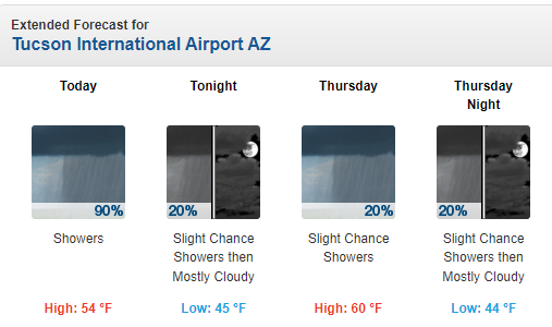
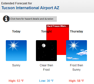
The 250 mb analysis (above) this morning shows a strong short wave from the Four Corners southward across the middle GoC. The very strong jetstream on the west side of the trough will bring a weaker trough across our area today. The morning sounding is quite dry below 450 mb (below). I'll be surprised tif we get showers here; however, current am forecast from NWS calls for 40 and 50 % POPs at the airport today and tonight. 


The 06 UTC GEFS plumes (above) also indicate slight chance for showers at airport this afternoon. The plumes are indicating chances for more significant rain at the airport from the 1st through the 3rd. This would be associated with a strong  wave approaching the Southwest (GFS forecast below is valid at 5:00 pm on the 1st). We're definitely heading into the New Year with a spell of cool and unsettled weather.

Wednesday, December 28, 2022

Light Rain This Morning


Vivid colors looking toward the Rincons a bit before 7:00 am MST this morning. Now, at 10:00 am, there is light rain here at house and light snow up in Summerhaven (bottom).

The 06 UTC GEFS plumes for QPF at the airport (above) indicate that today's event will be light (around 0.25"). However, at this time the ensemble members indicate that next event on New Year's Day will be more substantial - the operational GFS (blue line) is a heavy outlier at 2.00". This morning's forecast from the NWS for the airport is shown below. 

Current radar echoes at 10:00 am (above), and 12 UTC WRF-RR forecast for total precipitation through midnight. The WRF model forecasts a heavier event today for much of the metro area, although amount at airport is similar to the GEFS plumes. Should be interesting to see how this all turns out as day progresses.


Tuesday, December 27, 2022

Damp And Cool End To 2022


Cloud color over the Rincons at 6:45 am MST this morning.

Plumes from the 06 UTC runs of the GEFS - above for QPF at the airport, and below for temperature and wind. Good chances for rain tomorrow and again on New Years day. Note the very large range in amounts forecast by the ensemble members. Temperature cools significantly tomorrow through rest of week, and there's a chance for gusty winds tomorrow and on New Years.

This morning's NWS forecast for today through Thursday (above), and precipitation forecast from 06 GFS for the country through end of year (below).

Friday, December 23, 2022

Mild Christmas Weekend


View toward the Rincons at 6:30 am MST this morning. Fair and warm conditions prevail in our area, even though much of the country is being battered by arctic cold, winds, and snow. View at bottom is of the Notre Dame campus in South Bend, Indiana, at 6:15 am this morning.

In the longer term, changes are on the horizon beginning next Wednesday, the 28th, as per 06 UTC plumes for QPF (above) and temperature (below).

Forecast above shows GFS forecast (from 00 UTC) for 500 mb valid at 5:00 am on 30 December - as a strong short wave moves into New Mexico, after digging southeastward across Arizona. The WRF-GFS (below also from 00Z today) forecasts a very significant precipitation event for much of Arizona, as 2022 comes to an end.


Sunday, December 18, 2022

Chance Of Sprinkles

Heavy cloud cover across the metro area at about 7:00 am MST this Sunday morning.


The 12 UTC TWC/TUS sounding (above) shows a moist layer in mid-levels from 350 to 650 mb, but with very dry low-levels. At 500 mb there is a weak trough from southwest Utah down to northern Baja. This feature will move across Arizona today, bringing clearing with it. However, as it moves eastward, there is a very slight chance for sprinkles this morning. The coming week, now to Christmas, will be mostly cool and dry.


Wednesday, December 14, 2022

Frosty Morning


The Geminid meteor shower is underway. The Atmo webcam pointed at the Rincons caught one at 6:00 am MST this morning. Down at bottom is pre-sunrise view of the Rincons at 7:00 am.


There was some light frost here at the house this morning, and our low was 26 F - first time low has gone below 30 F this winter. Temperatures were cold and mostly freezing or colder - morning lows from MesoWest are shown above.

The 06 UTC GEFS plumes for temperature this week are shown above. We can look forward to a gradual warm-up beginning tomorrow. Current NWS forecast for today and tomorrow is shown below.


Tuesday, December 13, 2022

Widespread Rain Event


Mostly clear skies at 7:53 am MST this morning. There was a light dusting of snow on the Catalina foothills with greater amounts up at higher elevations.

The 500 mb analysis this morning (above) shows the closed low has moved eastward and is centered over southeast Wyoming - not southeast Colorado as the analysis indicates. Note the 100 kt wind speed over southwest Kansas.

Shown here are event totals for rainfall from the ALERT network. There was a second, light period of precipitation after dark last night, but bulk of precipitation was with the morning rain. Note the numerous reports of more than half an inch. Here at the house we had 0.34" in the morning, and then another 0.04" around midnight - total of 0.38" for the event. 


Plumes for temperature (above from 06 UTC GEFS) indicate two more cold mornings and then moderating temperatures. Low temperature here this morning was 32 F, but it will likely drop into the 20s F tomorrow and Thursday mornings. Current NWS forecast for the airport shown below.

Finally a look ahead. The GFS forecast below is valid at 18 UTC on Christmas Day and indicates a large surface high will dominate the central US, but with some rain and snow in the Northwest and the Northeast.