skip to main |
skip to sidebar
Snow and colorful lights last night at Jackson, Wyoming. System discussed in yesterday's post moved right overhead last night and is over Sonora this morning - was a very dry system, with almost no precipitation reported as it passed southward over Arizona.
Looks like a quiet end to January, with slight chances for light showers early next week - all model forecasts here from 00 UTC forecast runs on 30th. The GEFS plumes for 3-hour precipitation amounts (above) indicate slight hope for Monday showers.
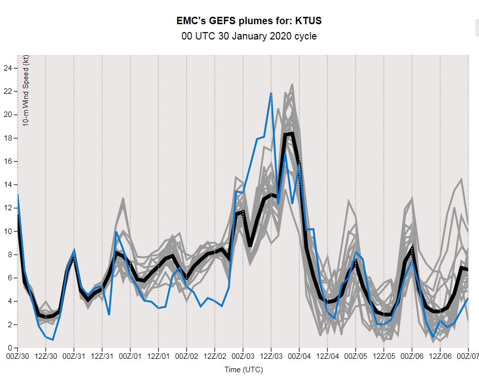
The plumes for temperature (above) forecast a dramatic cold front for Monday and Tuesday next week, along with a period of strong and gusty winds (below).
The changes come as a strong, 500 mb short wave passes by next Monday (forecast at bottom from the ECMWF).
Monday is a long way away, and we'll watch to see how situation actually evolves, but a bit of weather hope.
Clear skies at sunrise this morning - view from University above.
Forecast above (from 00 UTC GFS) indicates a strong, short wave over Arizona this evening. But north-to-south trajectory of this system is bringing little moisture with it, and showers will stay mostly over the Rim country and White Mountains.
Forecast below, from same run, is for total precipitation through midnight on the 4rth of February - leaving us dry into start of next month.
Below shows GEFS plumes forecast for temperature at airport for coming week. I've added dots for current NWS forecast, showing that the plumes tend to be cooler than forecast highs and warmer than forecast lows. Differences are most pronounced when skies are clear.
Clouds over Catalinas before sunrise above have mostly moved off to east. The outlook for rest of month is mostly continued much as per past few days. The forecast below is for total precipitation through midnight on the 31st - Arizona dry except for northeast third of state.
Snowy morning today in Lander, Wyoming above, and view below of Bullhead City, Arizona late yesterday below - with a few virga left side of image.
Nice contrast late yesterday: Crater Lake, Oregon above, vs sunset at Miami from across Biscayne Bay.
Grabbed the webcam views below from Jack Hales webcam wall yesterday afternoon. Three in Wyoming, and one in California.
Little to write about for final week of January. Fair skies over the Catalinas before sunrise this morning - above.
The weekend forecast (below from NWS this morning) indicates a mild and dry weekend with highs up into the low 70s. Great Chamber of Commerce winter weather.
These two panels are from the 06 UTC GEFS forecasts this morning. Above is temperature forecast for the airport - note that the GEFS plumes have a cool bias next few days, when compared to the NWS forecast above. The forecast of QPF for airport from same model runs (below) indicates the slightest chance for light showers right at end of month. Will follow this possibility as week progresses.
Little fog locally, but view of Catalinas (above) shows stratus hugging foothills; spots of sunshine catching some mid-elevations; and heavy cloud over higher elevations. However, fog is heavy up at Coolidge (bottom, with map showing location).
Plots of ALERT site rainfall yesterday (north above and south below) show amounts generally from about a quarter to a bit more than a third of an inch. Fifteen sites had half an inch and more - generally on north sides of Catalinas and Rincons. Note that snow level was very high, with Mt. Lemmon sites reporting rain.
The airport reported 0.42"; DM 0.37"; Atmo 0.35"; and here at house 0.35"
Light rain (at lower elevations) spread rapidly across metro since last post at about 5:30 am MST. The two plots below show ALERT precipitation for 3-hours ending at 8:00 am. Now there is 100% coverage of precipitation at ALERT sites.
Low clouds and light showers over metro before sunrise, obscuring the Catalinas.
Infrared satellite image (above at 6:11 am MST today) shows cloud stream from Pacific with coldest cloud tops out to our west. Composite radar below for 6:01 am shows heavier precipitation echoes, also to our west.
Raining lightly here at house currently. Only 5 sites in ALERT network have had 0.04" of rain so far - these are at the north and western edges of the network.
Forecast at bottom (from 06 UTC WRF-GFS) shows precipitation amounts through 5:00 pm this evening.
Heavy clouds over our area before sunrise on MLK Day.
The IR satellite image above (from 6:00 am MST) shows plume of high clouds from southwest extending over much of the West. As weak, but large, piece of western 500 mb trough swings across Arizona (forecast below from 00 UTC GFS valid at 6:00 am tomorrow morning), there will be a chance for showers across our area - much like the previous system on the 16th.
Plumes for QPF (from 03 UTC via SPC) at the airport above indicate rain chances late tonight through tomorrow morning. Average amount in forecasts only about 0.05" (heavy black line), again not a significant event. But, if you look back to the 16th, the plumes considerably under-forecast the QPF. Perhaps again? The forecast sounding below for TWC (from 06 UTC WRF-GFS) is valid tomorrow morning appears favorable, and is mostly saturated with PW of an inch.
Forecast for total precipitation at bottom (from same run and valid through 5:00 pm tomorrow afternoon) indicates amounts similar to the 16th, rather than very light amounts forecast by average of the plumes. Another wait and see event.
Lights of Tucson from Atmo early this morning. MLK weekend will be fair and dry here (current morning forecast for Oro Valley below) - other parts of country not so lucky.
Ely, Minnesota, above at 6:30 am CST this morning. Center of surface low producing the blizzard was near Duluth, Minnesota, at about 7:30 am (below).
Storm is causing serious travel problems for upper Midwest now (flight misery map at bottom), and problems will spread eastward over the weekend.
Bright, clear morning following yesterday's dreary skies and rain.
ALERT network rainfall yesterday for sites with 0.04" and more - north part of network above and south part below. Amounts across metro Tucson were generally around a tenth to a third of an inch. Here at house we had 0.22". Higher amounts occurred south of metro area as per graphic below.
Looks like coming seven days will be mild and dry.
View above is of heavy traffic, and heavy snowfall, on highway (numbered 20 in Wyoming and 33 in Idaho) that crosses Teton Pass (see map below). Traffic is heavy on this treacherous pass because Jackson is an elite and expensive tourist town. Many to most of the town's service and support workers can only afford to live over in the small, rural towns of Idaho. I'd certainly not want such a commute!