Friday, July 31, 2020
End Of July
Morning view from campus at 6:30 am MST this morning. Down at bottom is view of a wildfire burning near Mt. Wilson Observatory, in California, yesterday afternoon.
Extremely suppressed yesterday wrt thunderstorms. Plot above shows detected CG flashes for 24-hours ending at 1:00 am this morning (from Atmo and Vaisala). What can I say?
I have been noticing, for a number of weeks, that the operational GFS forecasts are wet outliers, in comparison to the GEFS forecast members. Don't know why this strange behavior is happening. Regardless, the GEFS forecasts indicate a very dry start to August.
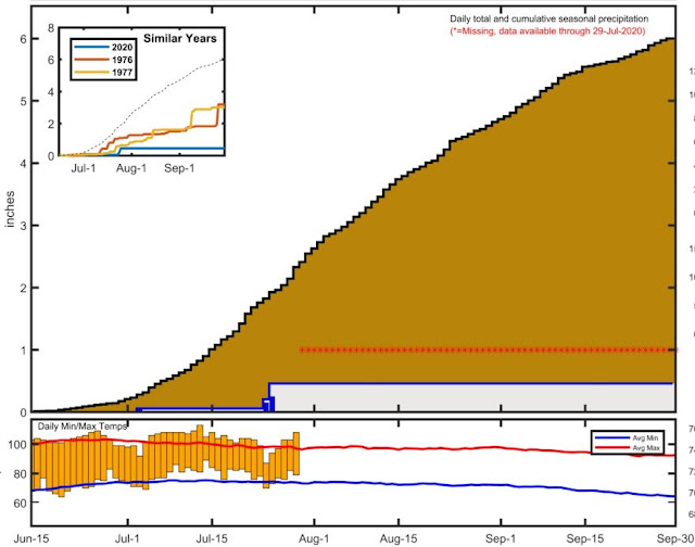
From the NWS webpage, plot above shows rainfall since June 15th for a number of stations in southeast Arizona. Here at house we had much more rainfall in July than did the airport, thanks to the heavy storms on the 23rd in this part of town. July ended up with 1.97" here, which is about at the median for my 22 years of observations.
Mike Crimmins' running plot for the summer so far at airport is shown below. Links to Mike's plots for a large number of sites are available at:
https://cals.arizona.edu/climate/misc/monsoon/monsoon_summaries.html
Wednesday, July 29, 2020
Hot And Hot And Hot.........
There are a few clouds this morning far off to south of Kitt Peak in Mexico.
There were some thunderstorms around eastern Pima County yesterday afternoon, as per plot of detected CG flashes for 24-hours ending at 2:30 am MST last night (from Atmo and Vaisala). Nothing here at house; 15 ALERT sites had light showers and a site in north Oro Valley reported over half an inch.
This morning skies are clear over all the Southwest, with only a bit of cloud cover in northern Sonora.
The morning forecast from the NWS is very grim for rest of week - above and below. Caution needed for outdoor activities, except around sunrise and sunset.
The 500 mb anticyclone builds strongly northward, reaching to the Arctic Circle by 5:00 pm on August 5th (as per the 00 UTC WRF-GFS forecast above). Forecast below from same run is for total rainfall during period ending at same time as above.
Back to having to water sensitive outdoor plants again.
Tuesday, July 28, 2020
Ending A Boring July
Alto cumulus drifting overhead about 8:00 am MST this morning. Seems we've been in the meteorological doldrums for much of July. One heavy rainfall event on the 23rd and little else.
Almost a donut hole in the CG flash plot (above, from Atmo and Vaisala) centered near or just west of downtown. Rainfall reports mostly in mountains and south to southeast of the city. There were, however, a number of sites that reported over half an inch.
Here at the house we had a brief spit of rain around 2:00 pm that wasn't enough to even wet the courtyard - so another Trace.
This morning's TWC sounding is very similar to yesterday's - see previous couple of discussions. Main difference today is that there are light westerly steering winds.
The 06 UTC GEFS plumes (below) for QPF at airport show some chance for light showers this early morning, which didn't happen, and then nothing for the coming week. Plumes for temperature (not shown) indicate gradual heating, and current NWS forecast high for Friday is 110 F - ugh.
Down at bottom is 12 UTC WRF-RR forecast for rainfall through midnight. That model forecasts isolated, light showers for eastern Pima County. Yet another day where chances for rain in the gauge here at house are very near zero.
August often makes up for a dismal July, and hopefully that will be the case this year.
Monday, July 27, 2020
Last Five Days Of July
Large Cb to the distant east-northeast last evening as the sun set.
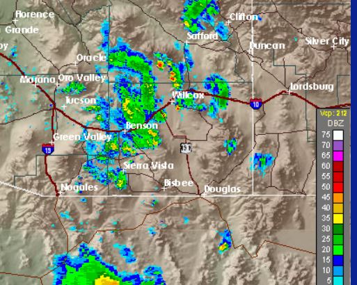
Was a suppressed day locally yesterday, with some thunderstorm activity to east and south in Cochise and Santa Cruz Counties. Composite radar chart above is from 5:00 pm MST yesterday, and plot of detected CG flashes (below - from Atmo and Vaisala) is for 24-hours ending at 1:00 am this early morning.
Visible satellite image above is from about 7:30 am this morning. Hurricane Hanna has dissipated, but left heavy cloud cover across central Mexico. Also a bit of debris cloudiness drifting across Cochise County.
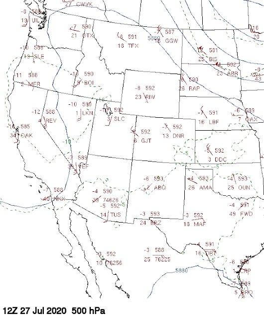
The 500 mb analysis this morning (below from University of Wyoming weather page) shows a large but weak trough along West Coast and a very large, and also weak, anticyclone covering the rest of the West. The high's main circulation center is between Amarillo and Midland, Texas. The observed 500 mb temperatures are very warm over southern Arizona and northern Mexico, i.e., -3 to -5 C which is a distinct negative for storms over lower elevations.
The morning sounding at TWC is also a very mixed bag: winds are very light below 300 mb; residual BL is shallow with drying 850 to 700 mb; however, PW is high, at just over an inch and a half. There are no clear steering level winds that would move storms far from higher elevations.
The 12 UTC WRF-NAM forecast below is for rain amounts through midnight tonight. Amounts are very light and also suggest a Tucson donut hole.
Between now and Wednesday morning, the main anticyclone center shifts westward, ending up to our west and northwest for much of coming week - not a good pattern for precipitation chances here. So, today may be last shot for July rain. Here at house, I'd be amazed if we get rain in the gauge, since the storm would have to develop nearly overhead, or build southwestward off the Catalinas.
Saturday, July 25, 2020
Mostly Down Day Yesterday
More middle clouds overhead today.
Visible satellite image at a bit after 7:00 am MST this morning (above) shows widespread debris cloudiness over eastern Arizona. Hurricane Hanna is nearing landfall around Corpus Christi this morning. Remains to be seen whether residual showers and cloudiness from the storm will reach this far northwest.
Yesterday had very limited thunderstorm activity, as is typical after a widespread rain day. Not sure why NWS hung on to POPs greater than 50% through most of day. Above shows radar echoes at 7:00 pm and below is detected CGs (from Atmo and Vaisala) for 24-hours ending at 8:00 am this morning.
Metro area ALERT reports for 24-hours ending at 8:00 am this morning is second below - few amounts and they are very light, except for one site in the Catalinas
An aside - using the old meteorological definition of the start of monsoon (i.e. three consecutive days of average dewpoint 54 F or greater at airport) is preferable (to me), rather than just saying there is a "Monsoon Season" period beginning June 15th, as per current NWS practice. Plot of average daily dewpoint (below) at TUS indicates, by old definition, monsoon began here on July 22nd - about two weeks later than usual.
Friday, July 24, 2020
Quick Look At Today
Heavy clouds above continued over the Catalinas at about 9:00 am MST this morning, but blue skies were visible out to the west. Visible satellite image below is from 8:30 am - clouds over north Mexico and southeast Arizona, with Tropical Storm Hanna over in the GoM. Hanna may bring much increased PWs into northern Mexico over the weekend.
At 500 mb this morning (above), we continue on the far west edge of the large anticyclone over Oklahoma/Kansas border. A very weak trough extends from southern California southward to the mouth of the GoC. The morning sounding (below) from TWC continues with very high PW, and CAPE that will be present if we get some heating by afternoon. Note that winds continue to be light and variable below 300 mb, with no distinct steering flows.
Forecasts here for composite radar echoes both develop storms over eastern Pima County this afternoon - above is valid at 6:00 pm from the 12 UTC WRF-RR and below is valid at 5:00 pm from the 12 UTC WRF-NAM. The 06 UTC WRF-GFS was suppressed this afternoon, but then developed storms our area around 2:00 am on the 25th.
July 23rd - Finally A Significant Rain Event
Yesterday brought the first widespread rains to our area since the middle of March - the end of a four month local drought. Storms and rain were heaviest here during the morning hours and by early afternoon had diminished to to light showers and sprinkles. Image from campus above shows visibility restricted, probably less than a mile, during the heavy rains. Plot of detected CG flashes below (from Atmo and Vaisala) is for 24-hours ending at 2:00 am MST this morning - a very active day for much of Arizona.
Using rain reports here from both the ALERT network and also from Univ. of Utah's MesoWest. There were many reports over an inch in the north part of the ALERT area - here at house I measured 1.76". Note the 3.62" and 3.18: amounts west of downtown. MesoWest plot at bottom shows reports for rest of southeast Arizona.
Finally, at end of day, a bit of sun poked through under the high, gray overcast.
Thursday, July 23, 2020
Stormy Morning Parts Of Metro Area - Updated
Three-hour rain amounts ending at 10:30 am MST for north half of ALERT area. Very heavy rain and thunder here last 45 minutes or so, still moderate rain and I can't go out to read gauge.
Very heavy thunderstorm above is just to the east of the house at this time. Earlier storm drifted off Catalinas and there was a brief shower, with thunder rumbling, here that left 0.15" in the gauge - biggest rain event here since March 18th!
The NWS has issued a Flash Flood Watch (below) that is in effect until midnight tomorrow night.
Significant storms cover much of southeast Arizona at this time (radar chart above from 7:30 am MST). Plot of detected CG flashes (below, from Atmo and Vaisala) is for 24-hours ending at 7:30 - whites and pinks are flashes in past couple of hours. ALERT rain amounts ending at same time (second below) indicate several sites in Catalinas with amounts around an inch.
The 500 mb chart above (from University of Wyoming weather page) shows that we remain on the far west side of the large anticyclone centered over Oklahoma, while trough to west inched across much of Arizona. Note - I used the Wyoming 500 mb because those from NCAR RAP and NWS EMC were affected negatively by suspect heights at Chihuahua, Mexico, and Phoenix.
The morning TWC sounding (below) is very wet (1.77" PW) and with considerable CAPE. There are some clear skies out west, but it is not obvious whether any of that will inch eastward.
Great to find some rain in the gauge, after more than four months of local drought.
Two tropical systems of interest: above shows NHC morning forecast for current depression in the GoM with system expected to become a TS and head into south Texas and northern Mexico; below shows current forecast for Cat 3 hurricane Douglas as it heads westward toward Hawaii.
Subscribe to:
Posts (Atom)


