Thursday, February 29, 2024

Yesterday's Rains

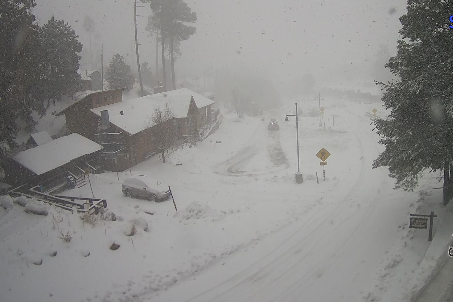
Difficult driving conditions on I-10 through Tucson at 2:30 pm MST yesterday afternoon.

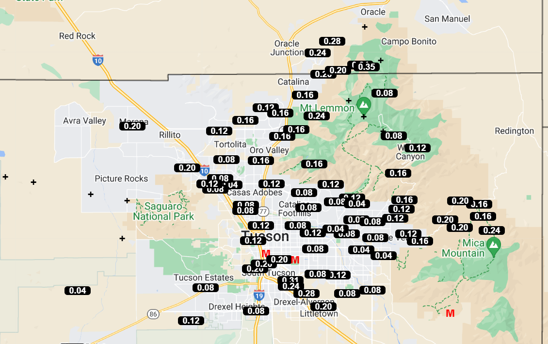
ALERT data (above and below) indicate 100 % coverage of measurable rain across the network. (Note the gauge at I-10 and Cienega Wash is obviously out of commission.) I counted 16 sites with half an inch or more.

Here at house we had 0.26" during the middle of the day. TUS reported 0.16"; DM had 0.25"; and Atmo recorded 0.26".


Plot of detected CG flashes (from Atmo and Vaisala) for 24-hours ending 0833Z today (above) indicates widespread thunderstorm activity across all of southeast Arizona, southwest New Mexico, and northern Mexico.

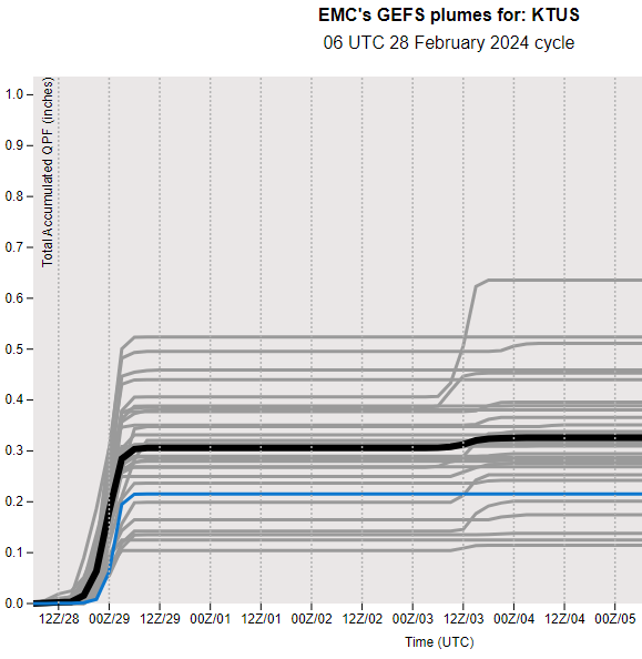
Plumes from 06 UTC for QPF (below) indicate a quiet first week of March is on tap. 

Wednesday, February 28, 2024

Showers Likely This Afternoon


Mostly clear skies this morning at 7:55 am MST.


The 500 mb low near northern Baja is forecast to move eastward across northern Mexico and southern Arizona during the day today - 06 UTC GFS forecast above is valid at 5:00 pm this afternoon.

The GEFS plumes for QPF at the airport have been very consistent during past few days, forecasting an average of 0.2 to 0.3"  this afternoon and tonight - as per above. The 12 UTC WRF-RR forecast (below) forecasts widespread precipitation across all of Pima County for period ending at midnight tonight. Current NWS Forecast Office graphic forecast for today and tonight is shown at the bottom.


Tuesday, February 27, 2024

More Showers Tomorrow


Heavy cloud cover continues over the metro area.

There were some thunderstorms yesterday evening over far eastern Pima County and the Catalinas - as per plot of detected CG flashes (above, from Atmo and Vaisala). Rainfall was generally very light - MesoWest plot (from Univ. of Utah) of amounts through 0730 am MST this morning is shown below. Here at house we had light showers around 5:00 pm that produced only 0.01".


Plumes for QPF (above) indicate good chances for more showers tomorrow and slight chances next Saturday night.

Plumes for temperature (above) forecast a roller-coaster week, with coldest temperatures occurring next Sunday. Winds peak on Saturday according to the plumes below. Regardless, a very unsettled week lies ahead. Plot at bottom shows 06 UTC WRF-GFS forecast of precipitation through midnight Wednesday night.


Monday, February 26, 2024

Light, Morning Showers

Heavy cloud cover across the metro area at 6:50 am MST this morning.

The IR satellite image from 1430 UTC (above) shows two cyclonic circulations west of California and a large cloud area moving across southern California and Arizona. Base scan radar from TUS radar at 1450 UTC (below) shows showers affecting the northwest and southeast corners of metro area. There was a light sprinkle here a bit ago, and the airport reported thunder with 0.01" of rain - DM had thunder and a Trace.


Forecast for 500 mb (from 06 UTC GFS - above, valid at 18 UTC on the 28th) indicates that the lows west of California consolidate into a weak low that moves across Arizona on Wednesday. GEFS plumes for QPF from 06 UTC (below) indicate good chances for rain amounts at the airport near half an inch on Wednesday.

At bottom is current morning graphic from the NWS web page at TUS.


Wednesday, February 21, 2024

Beautiful Sunrise


A golden orange sunrise at 7:00 am MST this morning, looking toward Redington Pass.

The 06 UTC GEFS plumes (QPF above and T below) indicate a chance for showers early next week, as well as continued mild temperatures through the weekend.

Tuesday, February 20, 2024

Summary 2023

 I'm more than a bit late getting this summary together for events here at the house during 2023.


View above shows a severe thunderstorm approaching our location from the east on July 17th. Storm took down trees here, and I estimated gusts of 60 to 65 mph.

For the entire year there was a total of 9.07 inches of precipitation. There were two months with no precipitation (April and June) and four months with over an inch (January, February, July, and December).  There was a light dusting of snow here on March 2nd. This was the fourth driest year at the house since I started my records in 1999.

I noted thunder here on 13 days, but that's likely a bit low because of my poor hearing. Coldest morning here was 23 F on February 16th, and first 100 F day at the airport was on April 30th.

Sunday, February 11, 2024

End Of The Rainy Period

Snow and some clouds on the Catalinas at 7:47 am MST this morning.


ALERT observations for 24-hours ending at 10:00 am (above and below). Here at house we had 0.20" - DM had 0.32"; TUS had 0.23"; and Atmo reported 0.17". Forecasts indicate that the rainy period has ended and that week ahead should be mild and dry.

Saturday, February 10, 2024

Another Rainy Morning


View looking toward the Rincons at 7:05 am MST this morning.

Quite a few ALERT sites did not reach amounts of 0.04" for 24-hours ending at 8:00 am this morning. Currently it is raining light here at house and there is 0.08" in the gauge.


Plumes for QPF from 06 UTC (above) are now indicating average precipitation at airport today around 0.35". Plumes for P-type (below) indicate a slight chance for some snow mixed with the rain. The current NWS forecast at bottom is going for rain and snow mixed at the airport, with a Winter Weather Advisory in effect.


Friday, February 09, 2024

Showers Yesterday And Again Tomorrow

View looking toward Table Mountain and Finger Rock at 7:50 am MST this morning.

ALERT data again show almost 100 percent coverage across network of rain amounts greater than 0.04". Amounts were generally less than half an inch. Here at house we had 0.14" before 11:00 pm. DM reported 0.20", TUS had 0.19", and Atmo had 0.11".


Forecast from 06 UTC GFS for 500 mb (above - valid at 12 UTC tomorrow morning) indicates a strong trough over Arizona. The 12 UTC WRF-RR forecast from Atmo (below - for precipitation through midnight tomorrow night) indicates another significant event for southeastern Arizona.


Plumes from the GEFS for QPF at the airport (above) continue to indicate average amounts near 0.40" tomorrow. The GEFS runs also indicate some chances for snow to be mixed with the rain, as per precipitation type forecasts (below).

Thursday, February 08, 2024

Light Rains Yesterday


Some snow cover visible on west end of Catalinas this morning. Image at bottom shows heavy snow falling in Summerhaven at 11:40 am MST yesterday morning.

Rainfall amounts from the ALERT network (above and below) for 24-hours ending at 8:00 am this morning. Only a few sites had over half an inch. Here at house we had an additional 0.29" during the day, making the event total here 0.42". Yesterday's rain at airport was 0.12"; at DM it was 0.12"; and at Atmo it was 0.19".


A strong short wave is forecast to move across Arizona on Saturday the 10th. Above 500 mb forecast from 06 UTC GFS is valid at 18 UTC on Saturday. The 06 UTC GEFS plumes for QPF at airport (below) indicate a minor event later today, but then a fairly significant event on Saturday.

Wednesday, February 07, 2024

More Showers?


Bit of blue peeking through the clouds over the Catalinas. Image at bottom shows a few inches of new snow up in Summerhaven this morning.

Rain amounts, mostly light, were recorded at almost all ALERT sites (above and below) for 24-hours ending at 8:00 am MST this morning. Here at house we had 0.13" around midnight. The airport had 0.13"; Atmo recorded 0.11"; and DM had 0.09".

Strong, gusty winds were also common over southeastern Arizona yesterday afternoon: airport reported a gust to 59 mph. Guthrie and Pioneer Airfield also had gusts over 50 mph.


At 500 mb (above)the main trough line remains a bit west of Arizona - note the very cold temperatures with the trough. The morning sounding from TWC/TUS (below) is very dry above 500 mb, with perhaps a sliver of CAPE below.


The GEFS plumes for QPF at the airport (abpve) indicate chances for afternoon showers through Saturday. The current morning forecast from TUS NWS (below) has 80 % POPS for today, along with a chance for thunderstorms.