Saturday, April 30, 2022

April 30th


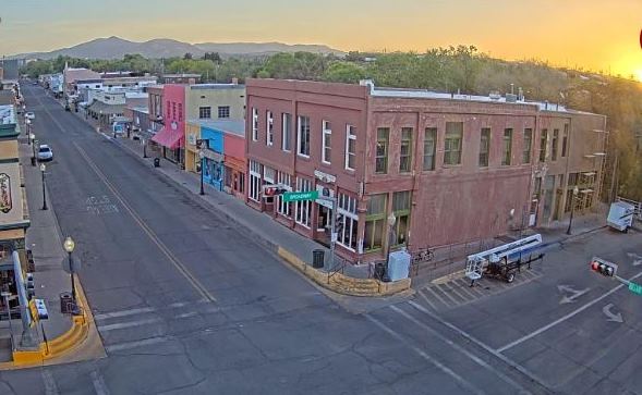
Morning pre-sunrise view with some city lights, dark mountains, and blue skies. Shown at bottom: pre-sunrise view to east in Aspen, Colorado; and the Targhee, Wyoming, snow stake (quite a contrast to here).


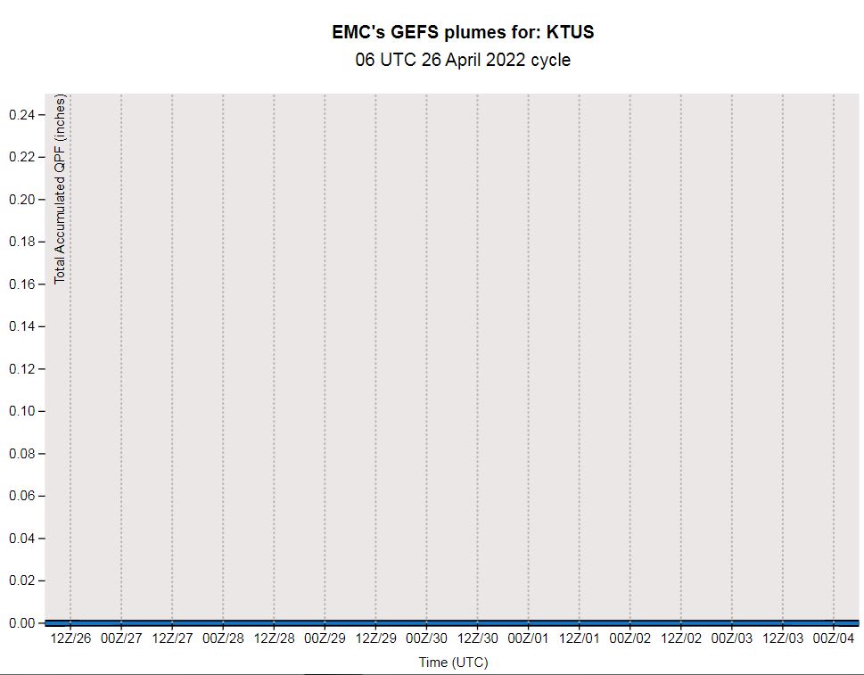
Current forecast for the airport this weekend. Although not noted above, winds Sunday expected to gust as high as 34 mph, and to 25 mph on Monday. Warm temperatures and low relative humidity - 4 % on Thursday afternoon and 8 % yesterday afternoon - combine with the afternoon winds to keep fire dangers high across southeast Arizona.


Tuesday, April 26, 2022

Last Few Days Of April


Views near and just after sunrise this morning: above from campus, bottom at Silver City, New Mexico, and Bisbee. Note the dirty skies at Tucson from dust aloft after several days of strong winds across Arizona.

Not much weather to talk about as April draws to a close. Plumes shown here from 06 UTC GEFS are for: precipitation above - totally flat-lined into early May; below temperature continues warm to hot; and second below wind, with several days indicated to be gusty - particularly May Day.


Below shows GFS precipitation (from 06 UTC run) out through 360 hours (i.e., through May 10th) - Southwest drought continues and worsens.


Monday, April 25, 2022

Today is:


Opus from Bloom County.

Friday, April 22, 2022

52 Years


Today is the 52nd Earth Day, and it dawns perfectly clear here in Tucson. Below is the famous Walt Kelly/Pogo poster from the first Earth Day in 1970.

Friday, April 15, 2022

Hot Afternoons


Views of the Catalinas this morning: above at 6:15 am MST and bottom at 5:55 am.

Current NWS forecast for Sunday through Tuesday (above) indicates highs going into middle nineties.

The 00 UTC WRF-GFS forecast for precipitation during next seven days (above) indicates almost nothing for Arizona and New Mexico.

The current seasonal outlooks from NWS Climate Prediction Center (above and below) call for continued above normal temperatures, but with equal chances for above or below normal precipitation. The precipitation outlook is essentially for July, since May and June are typically very dry across the Southwest  (see second below - plot of precipitation averages for airport).


The US drought monitor (below) indicates persistent drought continuing for most of the western half of the country.


Tuesday, April 12, 2022

More Wind Today


Views looking north along I-10 near Marana: above is from a bit before 6:00 am MST this morning - note the Palo Verde tress in full bloom in median and west side of highway. This is a very "yellow" time of year here in Arizona. Bottom is from yesterday at about 11:00 am, showing blowing dust to the north - you can just make out Picacho Peak west of Interstate in distant north.

It was quite windy yesterday - observations below from airport indicate gusts of 25 to 35 mph through most of the day.


The southern end of a 500 mb short wave (12 UTC analysis above) that extends from the Great Basin south along western border of Arizona will swing northeastward across the state today. This will keep the gusty winds going - 06 UTC WRF-GFS forecast for 10-m winds - below - is valid at 3:00 pm this afternoon. When I walked a bit before 8:00 am this morning, winds were already gusting 20 to 25 mph along the Rillito.


Monday, April 11, 2022

Continued Dry


Cirrus over the Catalinas before sunrise this morning. We are starting the second full week of April with no precipitation on the horizon, as our very dry 2022 continues.

The 06 UTC GEFS plumes for temperature (above) indicate cooler days tomorrow and Wednesday, and then a quick return to warm temperatures. Same forecast for PW (below) starts out dry and then plummets to very dry on Wednesday through the weekend


Our main weather impacts will be due to strong and gusty winds today and tomorrow - plumes above and 06 UTC WRF-GFS forecast for steady wind speeds at 10:30 am this morning (below). The NWS has out a Red Flag warning across all of southeast Arizona for critical fire conditions (warm, windy, and low RH) through 7:00 pm MST this evening. The GEFS forecast for winds (above) indicates those conditions will continue tomorrow.

Friday, April 08, 2022

Warm And Some Winds


Sunrise shots this morning from Wilcox (above) and from Mt. Bigelow in the Catalinas (bottom).

Weather here continues warm and dry, but some winds and cooling are ahead of us. The graphic below shows total precipitable water (TPW) at 12 UTC this morning. Almost all of the US is dry to very dry - a fairly unusual extent of dryness, that extends to Canada and much of Mexico.


Plumes from the GEFS at 06 UTC are shown here: QPF above indicates little chance for precipitation at airport for most of the coming week; temperatures are forecast to fall slowly and then warm some, with Tuesday and Wednesday next week being the coolest days; and winds (second below) are forecast to be fairly strong tomorrow through next Tuesday.


Forecast below is from 00Z WRF-GFS and shows no precipitation across our area through next Friday. Looks like I'll have to be watering some of the yard plants a time or two during the week.


Monday, April 04, 2022

Warm To Hot Coming Week


Some pinks on the scattered clouds this morning before sunrise - above Catalinas at 6:15 am MST and bottom east from San Simon at 6:10 am.


The week ahead is forecast to be warm to hot and continued dry. Plumes here from the 06 UTC run of the GEFS forecasts: above QPF and below temperature and wind. Temperatures increase through Saturday and then fall markedly by next Monday. The cool down has some gusty winds indicated also. 

Note that current NWS forecast is for high next Saturday of 94 F.


Sunday, April 03, 2022

Forty Eight Years Ago


The super tornado outbreak of April 3/4 occurred 48 years ago today. Map of tornadoes documented by Ted Fujita is shown above.

There were 148 tornadoes documented, and 30 of these were violent F-4 and F-5 tornadoes. Photos below show tornadoes that hit Xenia, Ohio, and Hanover/Madison, Indiana. The tornadoes resulted in 335 deaths.

I was a forecaster in the Military Weather Warning Center (MWWC) at Offutt AFB, Nebraska back then. I was not on duty this day, but wanted to go in to work during early afternoon, when it was apparent that a significant severe storm outbreak was underway. Failed in this effort because we were experiencing freezing rain and sleet, and I could not get out of our driveway.

Friday, April 01, 2022

March Summary And April Outlook

Clear skies over Catalinas, viewed from campus at 6:30 am MST this April Fools Day. Colorful sunrise and some high clouds looking east from San Simon at 5:50 am (bottom).

Summary for March: Total precipitation was 0.33"; falling on two days - the 20th and 24th. This was the tenth driest March since 1999 here at the house - little precipitation, but not unusual for here. There were 4 days with morning lows of 32 F or colder, with coldest being 27 F on the 10th.


The monthly outlooks from NWS Climate Prediction Center (CPC) for April are shown here. Little change expected from CPC for Arizona: above normal temperatures and below normal precipitation, as our long-term drought continues.


Forecast for precipitation through 5:00 pm on 15 April (above from 00 UTC GFS) shows almost nothing for the entire state. Plumes for temperatures for coming week below (from 06 UTC GEFS) indicate mild temperatures through the period.