skip to main |
skip to sidebar
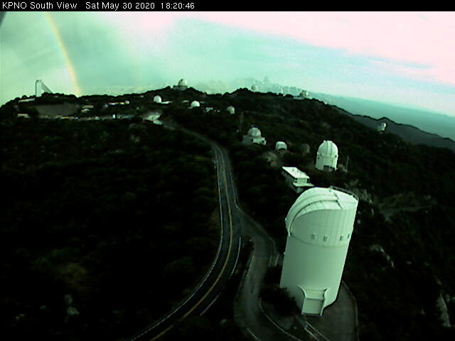
Mammatus overhead about 6:00 pm MST yesterday afternoon (above). View from Kitt Peak south at 6:20 pm (bottom) captured a rainbow just off to the east.
Interesting afternoon yesterday as strongest storms stayed off to west of Metro area, but with thick anvils overspreading the city. Composite radar chart above from 3:39 pm, and detected CGs below for 4 hours ending at 6:00 pm. Light showers from the weak echos just west of airport produced outflows that resulted in gusts to 69 mph at airport and 51 mph at DM AFB. The winds were clearly associated with deep convection, and were thus the first severe thunderstorm event at the airport this year. Unfortunately, the Forecast Office chose not to report the event to SPC
The TWC sounding plot this morning remains similar to past couple of mornings. Yesterdays WRF runs at Atmo forecasted storms over Metro area, and they do so again this morning - perhaps activity will shift a bit eastward today?
Finally current 500 mb analysis (below) shows a closed low (this is a deep feature extending from 700 to 200 mb) over northwestern Mexico, with an inverted trough extending northwestward across the Big Bend. Unfortunately, the models forecast this feature to to weaken and move northward, so it will have little effect on the evolution of local area storms.
View above from campus at 4:00 pm MST yesterday when thunderstorms and light showers were in the area. Neighbor John Ferner reported thunder here around 3:00 pm, but there were only a few sprinkles.
The TWC sounding from 5:00 pm last evening (above) has only slight CAPE above 600 mb, but combined with afternoon temperatures of 105 to 110 F, thunderstorms developed across much of southeast Arizona. Plot below shows detected CG flashes for 24-hours ending at 2:00 am this early morning (color code indicates hours before 2:00 am that flashes were detected (so storm activity was mostly ended by around 5:00 pm on Friday).
Second below shows 24 hour rainfall amounts through 8:00 am this morning (from MesoWest) - only a few sites had light but measurable rainfall. However, note the 0.91" at Muleshoe Ranch over to east of the San Pedro River.
This morning's 12 UTC 500 mb analysis (above from NCAR RAP) shows that we are on the southeast side of a weak anticyclone centered over Colorado/New Mexico border. The MIMIC analysis of PW (below, for 7:00 am this morning) shows broad area of higher moisture from GoC extends northward across southern half of Arizona (light blues indicate an inch or more, while the yellowish area in central GoC idicates amounts above an inch and a half).
This morning's TWC sounding at bottom is similar to yesterday's, with a sliver of CAPE above 600 mb. NWS forecasts this morning incate chances of afternoon and evening rainfall at airport at around 20 % and current WRF forecasts indicate some afternoon/evening thunderstorms across parts of eastern Pima County. So, a bit of a hint of things to come closes out May.
Thunderstorms developed quickly in our area after noon today. I have to admit I've been busy with other issues and didn't get a chance to look at the weather charts this morning. View above from Atmo at 3:35 pm MST this afternoon.
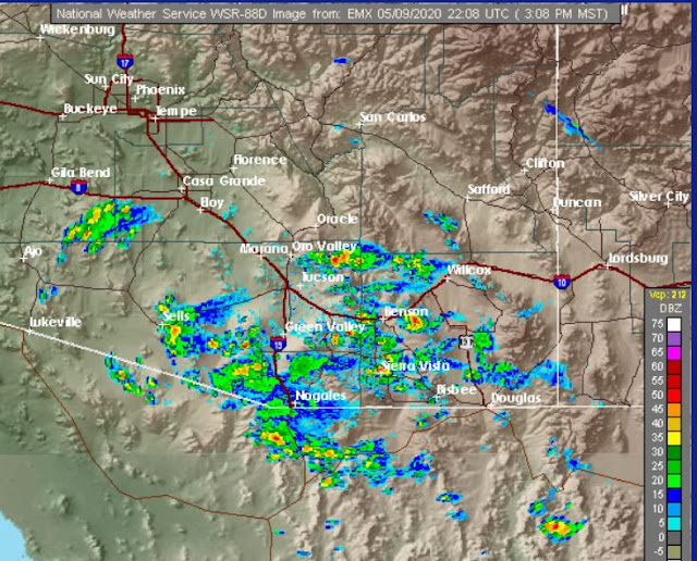
Radar below is composite from 3:21 pm. We were at the Tucson Mall west-northwest of here, and there was a moderate to heavy shower as we left.
Haven't heard any thunder, but plot of detected CGs for last 3 hours (above) shows that thunderstorms are occurring in much of southeastern Arizona.
The morning GEFS plumes for QPF (below) indicates afternoon and evening showers through the weekend and into first couple of days of June.
Clear skies continue over Arizona - view south from Kitt Peak this morning above. Visible satellite image below, from yesterday morning, shows no clouds over most of the Southwest. Image down at bottom shows multiple contrails over the Superstitions this morning.
Forecast above from 00 UTC GFS is for total precipitation through 5:00 pm MST on the 28th of May. Plumes from GEFS 06 UTC runs below - top is temperature showing relatively cool temperatures through the weekend, but them a rapid increase in temperatures that will bring back 100+ F heat during the week. Second below shows very low PW values, but with increasing values as next weekend approaches. I'm certainly looking forward for late June and the eventual start of the summer thunderstorm season!
Yesterday afternoon winds were gusting in the mid-to-upper 20 mph hour range. There remains some suspended dust in the air, giving us skies that are a bit dirty at sunrise (above).
The 500 mb pattern at 12 UTC (above) remains strongly blocked over the U.S., but the western trough is slowly pushing inland. The winds aloft here will increase a bit more, as the southern end of the trough swings slowly across Arizona (500 forecast below from 06 UTC GFS is valid at 12 UTC tomorrow).
The 06 UTC WRF-GFS forecast for today (above is valid at 2:00 pm MST this afternoon) indicates strong, south-southwesterly winds impacting much of Pima County - gusts will likely be up above 30 mph today.
Below is unwrapped am view from Mt. Lemmon SkyCenter - very pristine air up there, and the camera lens has been cleaned!
Storms north of Kitt Peak around 2:30 pm MST yesterday afternoon above. Below, lingering clouds this morning.
Looks like the coming week will be dry with afternoon temperatures in the 90s, and also some periods of gusty winds during the afternoons.
Second below shows ALERT plot for 24-hour rainfall through through 6:00 am this morning. Light amounts around the Catalinas, except for that one report of 0.67". There were also two sites with 0.04" in the south part of network. Here at house we had very light showers around 2:30 pm that were enough to just wet the patio for a few minutes - so a Trace of rain here for our first May "weather event."
Thunderstorms over eastern Catalinas at about 3:20 pm MST. Radar echoes (below, from about 3:10 pm) were mostly occurring over higher terrain from our east though south to southwest.
Most lightning flash activity was also from southeast to west of Tucson. Across the metro area an outflow from the southwest produced gusts around 30 mph, along with noticeable cooling, as it moved by around 5:00 pm. There were isolated reports of measurable rainfall at some sites in southeast Arizona (below from MesoWest).
Second below is 12 UTC skew-T plot for TWC morning sounding - steering flow remains weak, but CAPE and PW are a bit higher today. There are already showers over the Catalinas before 10:30 am. Should be an interesting day.
View of campus (east Mall) a bit after 7:00 am MST this morning - looks like there's one person walking toward east in this view.
Yesterday there were afternoon and evening thunderstorms in northern Mexico, and one storm affected the very southeast corner of Cochise County. Plot of detected CG flashes below is for 24-hours ending at midnight last night (from Atmo and Vaisala).
The 500 mb pattern this morning (above) shows a weak anticyclone centered somewhere over western Arizona. Stronger winds are restricted to northern parts of state. This morning's sounding for TWC (below) shows light/variable winds below 400 mb, PW a bit over 0.75", and no CAPE.
Forecasts (all from 06 UTC last night) indicate some increase in PW through the day tomorrow and then a rapid plunge during Sunday night (above PW plumes from GEFS). Forecast TWC sounding below (from WRF-GFS) is valid at noon tomorrow - only slight bit of CAPE forecast above 600 mb.
The GEFS plumes for QPF at airport (above) show showers at airport, mostly during day tomorrow, with very light rain amounts possible in those forecasts. The WRF-GFS forecast of rainfall amounts through midnight Sunday night, with a goose egg for the airport.
This is a pretty marginal situation, and I'd be surprised, but happy, to find measurable rain in the gauge here by Monday morning.
Some high clouds to east this morning - above. High temperatures yesterday (below) had very large range (more than 60 F) from Wyoming to southern California - high here was 102 F (third straight day over 100 F).
Models forecast a very slight chance for showers over parts of Arizona this weekend. Precipitation amounts forecast at airport (above from 06 UTC GEFS) indicate best chances at airport Saturday night into Sunday, with amounts averaging only about 0.07". Forecasts for PW (below - from same runs) show a peak reaching almost an inch on Sunday.
GEFS forecasts some CAPE over weekend (above from 06 UTC runs), so there may be thunderstorms around, especially Sunday), which would bring some local spots with heavier rain possible. The 06 UTC WRF-GFS forecast for amounts through 6:00 pm MST on Sunday show little of consequence for southeast Arizona. But cooler temperatures and higher RH will be a welcome change, even without rain in the gauge.


