Thursday, September 30, 2021

Showers Northern Metro Area


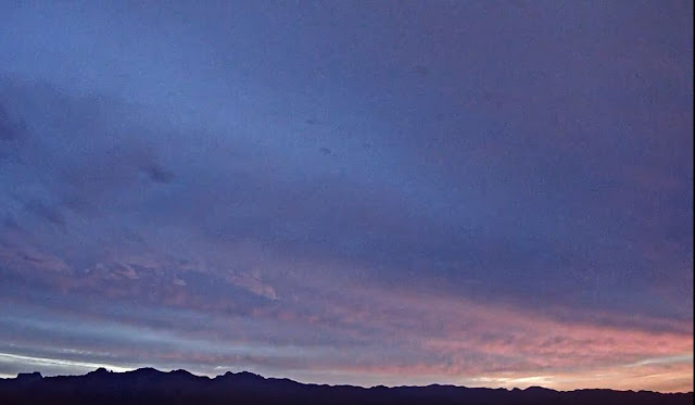
Lightning flash about 2:30 am MST this early morning captured on the Atmo movie. Showers and thunderstorms moved across the northern portions of the metro area after midnight last night.

Rain amounts from the ALERT network for 24 hours ending at 5:03 am. Yesterday's WRF was reasonably good in keeping the storms to the north. The airport reported 0.01", DM had a Trace, but we had 0.24" and Atmo reported 0.22". The plot of detected CG flashes (below from Atmo and Vaisala) shows considerable ongoing storm activity at 1203 UTC (5:03 am) - most recent flashes are pink to white.


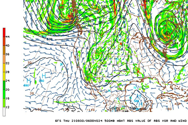
This morning the 500 mb trough continues its slow eastward movement and is located a bit west of Tucson. The 1430 UTC plot of PW above shows lingering values over an inch across most of southern Arizona. The GFS 500mb forecast below indicates the trough just to the east of here by 00 UTC this evening. Key forecast question is whether afternoon storms will develop. The 12 UTC WRF-RR forecast second below (precipitation through midnight tonight) indicates some activity just brushing the edges of eastern Pima County. I'd be surprised if we had thunderstorms again here at house. 


Wednesday, September 29, 2021

Interesting Situation

Early morning view of Catalinas from campus this morning. Down at bottom is image a bit after moonrise last night - about 11:30 pm MST. Note - if anyone knows what the flame or flare that burns on Catalinas each night is, please let me know.

There is a digging trough over the western US this morning - see strong jet on backside of the trough at 300 mb (above). The 500 mb forecast (below - from 12 UTC WRF-RR run at Atmo) indicates the trough north-to-south across Arizona at 06 UTC tonight. Forecast sounding for TUS/TWC valid at same time is second below. Sounding is quite moist (32 mm versus 22 mm this morning) with considerable CAPE.

However, the model's forecasts for accumulated rainfall seem a bit mysterious - above rain through midnight and below through noon tomorrow, with almost nothing for all of Pima County.

For comparison at bottom, is the morning forecast for the airport from the NWS.

Tuesday, September 28, 2021

Not Completely Quiet


Showers over the Catalinas after midnight (image above from about 4:00 am MST shows shower along the foothills) produced scattered rainfall - see ALERT reports below for 24 hours ending 8:00 am this morning. Here at house we had 0.01". Down at bottom is view of fuzzy lenticulars over western Catalinas.


Monday, September 27, 2021

Several Quiet Days On Tap

Lingering middle clouds over the Catalinas at a bit past 9:00 am MST this morning.

ALERT rainfall reports for 24 hours ending at 9:00 am this morning. Rain had mostly needed over the north portion of the network. Rain ended here before 9:00 am, and there was no more through the day and last night. Rain did continue during the day at sites in the southern part of the network, where 24-hour totals were generally larger.


The closed low at 500 mb (above) is now centered over the White Mountains, as it moves under the large ridge to its north.

Another system will be approaching by Wednesday, when the GEFS plumes for QPF forecast more rain at the airport Wednesday night through Thursday (above). The 06 WRF-GFS forecast for precipitation through 6:00 am tomorrow morning (below) shows Pima County almost completely shower free.


Sunday, September 26, 2021

Nice Early Morning Rain


Showers across the metro before sunrise this morning have resulted in first decent rain since September 5th - most welcome here at house.

The 500 low is now centered south of Yuma (above) and moving slowly eastward. Plot of GC flashes (from Atmo and Vaisala) detected during 24 hours ending at 8:23 am MST this mornin (below) shows some thunderstorm activity with the showers, and we heard one rumble of thunder here.


Rain amounts for 24 hours ending 9:00 am this morning abbove and below from ALERT network  show many amounts over half an inch and a few over an inch. Here at house there is 0.35" in the gauge now. It is a bit complicated since there may have been a couple of hundreths here before midnight - but I am logging all the rain for early am today, since I have no way of knowing how much might have happened before midnight.

Models and current NWS forecast (below), and also forecast discussion, emphasize rain and storms this afternoon. But, airport has already had 0.26" and Atmo has had 0.51", split about equally before and after midnight.


Saturday, September 25, 2021

Showers Around Today


View of showers northeast of Catalinas at 7:05 am MST this morning Below is 24 hour rainfall across the ALERT network. Most of precipitation fell after midnight last night. There was 0.02" here at the house - which was first measurable rain since September 5th.


At 500 mb the closed low appears to be centered somewhere south of San Diego at 12 UTC (above - from Univ. of Wyoming).

GEFS plumes from 06 UTC for precipitation at the airport are fairly aggressive late this afternoon through tomorrow. Average forecast by the ensemble is around 0.30", with the operational GFS (blue) quite a bit wetter. Morning sounding plot (below - also from Univ. of Wyoming) is fairly wet, but is also dry below 700 mb. The boundary layer will probably not heat and mix-out to 700 mb, so storms this afternoon will likely be high-based.


Forecasts here from 09 UTC WRF-RR: above shows composite radar forecast for 4:00 pm MST this afternoon and above shows forecast rainfall through midnight tonight. Amounts over our area are quite light - note difference at airport with WRF forecasting no rain in contrast to the GEFS shown above.

Friday, September 24, 2021

Showers Nearby This Morning


Late start this morning. Morning buildups and showers north and northwest of the Catalinas this morning. There was a very long-lived, partial rainbow with the showers, but I did not have my camera when I was out walking.

Very limited rainfall across the ALERT network for 24 hours ending at 9:00 am MST this morning (below). Here at house we had very light shower a bit before noon yesterday that produced a Trace.

Quite a bit of early morning CG flashes (second below) out to the west of here - looks like one detection with the showers near the Catalinas.


The morning 300 mb analysis (above) shows a very sharp trough across northwestern Arizona, and that will form a closed low later today off of northern Baja. This feature will affect our area when it moves eastward over the weekend.

The morning sounding from TUS/TWC below has just a sliver of mid-level CAPE with different wind profiles in the upper versus lower halves of the troposphere. Not a very promising sounding, although more CAPE is present to the west, as per thunderstorm CG activity shown above. 

The 12 UTC run of WRF-RR keeps most storm activity to west through midnight tonight - that model's forecast for rainfall through midnight tonight is shown at the bottom.


Thursday, September 23, 2021

Dreary Morning


Dreary morning with heavy cloud cover, but there was some color a bit before sunrise.

IR image (above from 1411 UTC or 7:11 am MST) shows an area of clouds over southeastern Arizona and northern Mexico. There is an area of light showers from southeast to southwest of the metro area. Some lightning was detected within past hour or so down in Santa Cruz County near the border. Composite radar below is from a bit before 7:00 am.


The 500 mb analysis this morning (above from SPC) shows that the shoer activity is associated with a weak short-wave trough to our south. Up at 300 mb (below) the trough is barely detectable. The short wave across the western US has a strong jetstream on its back side, which will result in the trough digging and becoming a closed low near San Diego by tomorrow.


The GEFS plumes for QPF at the airport (below from 06 UTC) show a slight chance for sprinkles/showers at airport today, but with the best chances for measurable rainfall occurring over the coming weekend, as the closed low slowly approaches.

Monday, September 20, 2021

Few Showers On Sunday


View of Catalinas and perfectly clear skies a bit before sunrise this morning.

Showers did develop yesterday afternoon, before the dry air took over. Looks like about 13 of the ALERT sites had 0.04" or a bit more rain for 24 hours ending at 6:00 am MST this morning - reports were mostly clustered at west end of the Catalinas. Not a drop here at the house. Last measurable rain here was more than two weeks ago.

Plot of detected CG flashes (below from Atmo and Vaisala) for 24 hours ending at about 2:00 am indicates isolated storms in Cochise County. There also appears to be one detection near the west end of Catalinas.

This morning's sounding (bottom) shows that Tucson area is now very dry and stable, and this will persist most of coming week. It was very cool with low humidity during my morning walk - which was very pleasant.