Thursday, August 31, 2023

Showers Yesterday


Showers over Redington Pass at 6:25 am MST this morning.

Plot of detected CG flashes (below from Atmo and Vaisala) through 0833 UTC indicates widespread thunderstorm activity yesterday over most of the metro area.


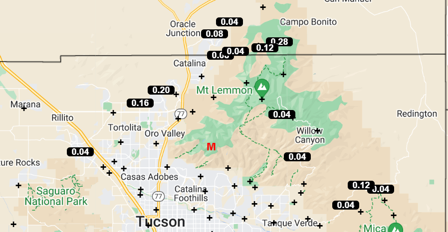
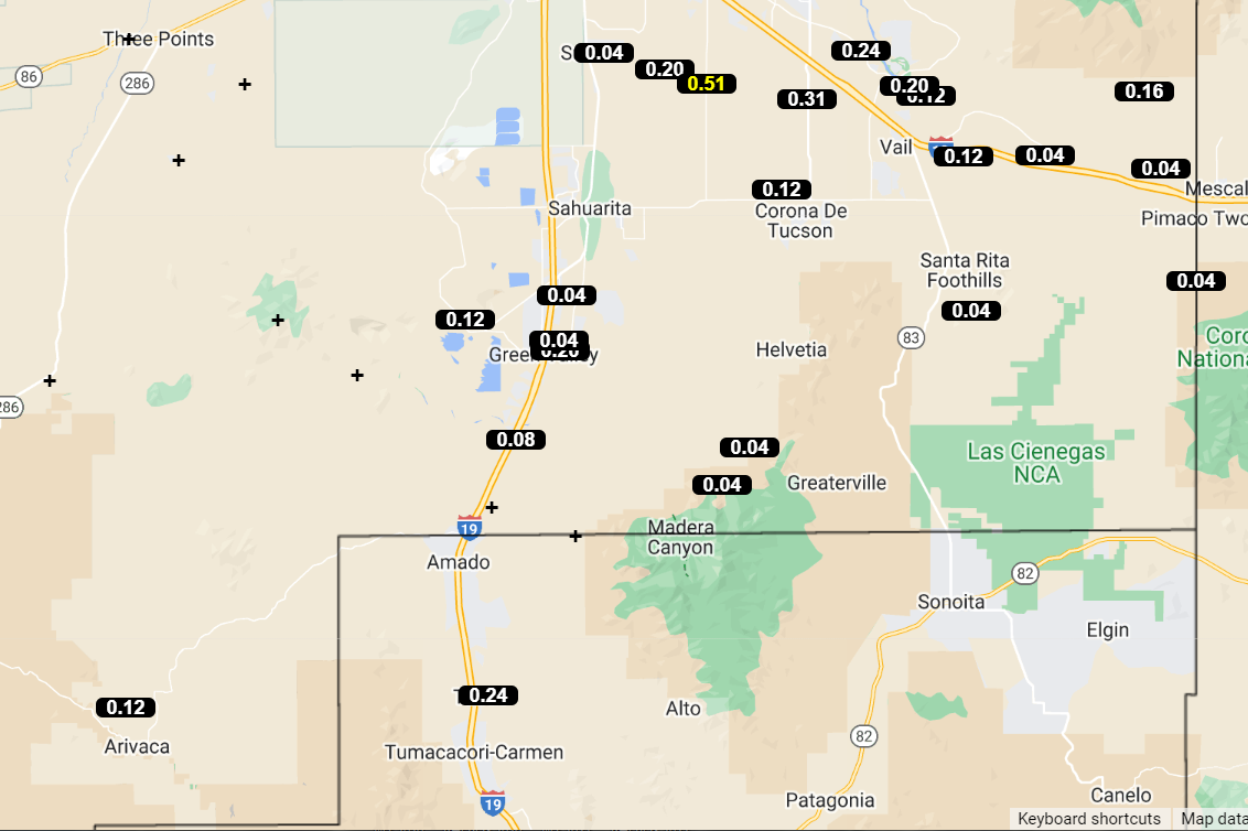
ALERT data for 24 hours ending 7:00 am this morning (above and below) shows rainfall over much of the network, with a number of sites recording over half an inch of rain.

Here at house we had thunder, wind gusts of 40 to 50 mph during the late afternoon, followed by showers after dark that left 0.13" in the gauge. The airport recorded gusts to 45 mph with 0.06"; DM reported gusts to 49 mph and 0.09"; Atmo had 0.06" along with gusts to 36 mph. There was one severe wind report in the east metro where gusts to 59 mph occurred.


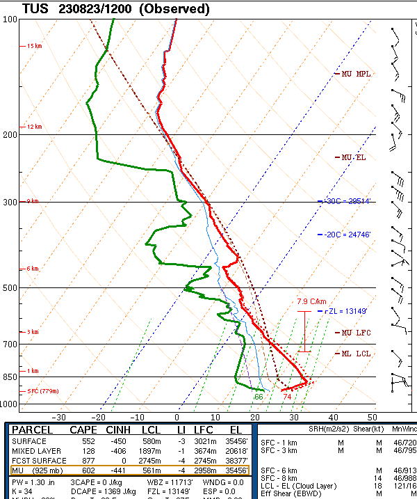
The morning sounding continues similar to last few days with a deep and relatively dry old BL and light winds aloft. Precipitable water was 1.21 inches, with just a sliver of CAPE.

The morning forecast from the NWS (above) notes a blowing dust advisory for today, along with high POPs through Saturday. Forecast below (from the 06 UTC WRF-GFS) shows rainfall through 10:30 am Sunday morning. The WRF forecast from yesterday morning verified quite well - see previous post.

Wednesday, August 30, 2023

Another Record

Towering cumulus over parts of the Catalinas at 5:50 am MST this morning. The high temperatue at the airport yesterday reached 108 F, breaking the previous record of 107 F set in 1985.

Tonight will be a blue super moon - the next one will not occur until 2037 (so quite a rare event tonight).


Plot of detected CG flashes (from Atmo and Vaisala) above is for 24 hours ending at 0833 UTC this morning. Isolated storms did occur yesterday in southeast Arizona and along the Rim country.
There were only two reports of rainfall across the entire ALERT network yesterday - .04 and .08" at two sites on Mt. Lemmon.


The 500 mb analysis this morning (above from SPC) shows an elongated anticyclone stretching from southern California to northern Kansa, with no distinct circulation centers. Hurricane Idalia made landfall in northern Florida this morning.

The morning sounding for TWC/TUS (below - also from SPC) continues un-impressive with a deep, dry BL and little CAPE, There is a layer of east-northeast winds of about 30 kt above 500 mb - so stronger steering flow compared to last several days.


Model forecasts vary widely this morning. The plumes from the 06 UTC GEFS (above) indicates a very active period Friday and Saturday, The 06 UTC WRF-GFS (below for period ending 6:00 am tomorrow morning) indicates an active day with widespread rainfall across the metro area. The current NWS forecast (bottom) indicates moderate to high POPs for the airport beginning tonight and extending through Saturday night.


Tuesday, August 29, 2023

Record High Yesterday


Another golden, pre-sunrise view to the northeast this morning. Yesterday's high temperature of 109 F set a new record high, breaking the 107 F recorded in 1998 and again in 2020.

Plot of detected CG flashes (above - from Atmo and Vaisala) for 24 hours ending at 0903 UTC this morning shows just some isolated flashes in the metro area yesterday. ALERT plot (below) for 24 hours ending at 8:00 am MST this morning rainfall shows light amounts on and near the mountains. In the south part of network Florida Canyon reported 0.12" and Arivaca had 0.04". Nothing here at the house.


The morning sounding for TWC/TUS (above) continues unimpressive, with light winds aloft and just a sliver of CAPE.

The 06 UTC WRF-GFS forecast (above) keeps Arizona basically rain-free through noon tomorrow. Morning NWS forecast POPs through Thursday are shown below. The nasty heat continues today and tomorrow.

Monday, August 28, 2023

Isolated Storms

View toward Redington Pass at 5:50 am MST this morning.


Plot of detected CG flashes through 0903 UTC this morning (from Atmo and Vaisala) indictes some thunderstorms in eastern Pima County. However, there is basically a donut hole over mush of the metro area.


Precipitation reports from Univ. of Utah MesoWest (above for 24 hours ending at 8:00 am this morning shows some rainfall in the northeast foothills. Note that the 0.01" report nrtheast of airport appears to be bad data.

Plumes for QPF at the airport (above) from the 06 UTC GEFS indicate an active weekend.

Forecast from the 12 UTC WRF-RR (below) indicates light showers across much of eastern Pima County through 6:00 am tomorrow morning.

Sunday, August 27, 2023

More Scattered Showers


A very bright Saturn dominates the pre-sunrise sky this morning.

Plot of detected CG flashes through 0703 UTC this morning (above from Atmo and Vaisala) shows thunderstorm activity occurred in parts of eastern Pima County. There may have been thunder here, but if there was, I didn't hear it.

ALERT network plots (above and below for 24 hours ending at 7:00 am MST this morning) show scattered showers over much of the northern portions of the network - except for a donut hole over northern parts of the metro area. No rain fell here at the house.


The 12 UTC WRF-RR forecast through noon tomorrow (above) indicates little precipitation in southern Arizona and also keeps most of that southwest of metro Tucson. The current NWS forecasts keep the Excessive Heat Warning through Tuesday, along with 20 percent POPs for the airport each day.

Saturday, August 26, 2023

Spotty Storms Yesterday


Heavy cloud cover over the metro area this morning at 7:10 am MST (above). Plot of detected CG flashes (below, from Atmo and Vaisala) for 24 hours ending at 0733 UTC this early morning shows spotty storm activity around eastern Pima County - definitely more than I expected when I wrote yesterday's post.


Plots from the ALERT network (above and below) are for 24 hours ending at 7:00 am this morning. Rain reports were scattered around the network. Amounts were mostly light, but there were two reports over half an inch.

Here at the house we had gusty winds to around 30 to 35 mph, with a light evening sprinkle giving us a Trace of rain. Atmo reported gusts to 32 mph and 0.16"; the airport had thunder and gusts to 37 mph, but no rain; and DM reported light showers with 0.01".


The morning sounding (above) is again not very impressive, with light and variable winds aloft and just a bit of mid-level CAPE.

However, the forecast from the 12 UTC WRF-RR (above) shows light precipitation over much of eastern Pima County through 6:00 am tomorrow. The NWS morning forecast (below) has 30 to 40 percent POPs today and tonight for the airport. There is an Excessive Heat Warning in effect Sunday well into next week, with only low POPs for rain at the airport. Not a great way to end August.

Friday, August 25, 2023

Another Suppressed Day


Looking toward Redington Pass at 05:50 am MST this morning.

Plot of detected CG flashes (from Atmo and Vaisala) for 24 hours ending at 0753 UTC this morning. Yesterday was mostly suppressed over much of Arizona. Across the ALERT network (below - 24 hours ending at 0753 UTC this morning) there were only 5 reports of light rainfall over the Catalinas and south end of Rincons.


This morning's sounding (above from SPC) is again not very impressive. Winds below 300 mb are very light and there is virtually no CAPE for a deeply mixed, afternoon BL (ignore the surface lifted parcel at time of the sounding).


Forecast from the 12 UTC WRF-RR (above from Atmo) is for period ending at noon tomorrow. Model keeps rainfall on the high elevations, but has nothing for the main metro area. However, the NWS morning forecast (below) keeps POPs for airport at 20 to 30 percent each forecast period through the weekend. Note also the return to temperatures around 105 F - ugh.

Thursday, August 24, 2023

Suppressed Day Yesterday

View looking toward the Rincons at 6:20 am MST this morning.

Little to report this morning. Thunderstorms (as per CG flashes below from Atmo and Vaisala) avoided eastern Pima County, but occurred to our south and west, including Santa Cruz County. There were only four rain reports across the ALERT network. Two sites in the Catalinas and Arivaca down south reported 0.04", while Tubac/Tumacacori was hit by one of the Santa Cruz storms and received 0.43".

Wednesday, August 23, 2023

Showers Again Yesterday


View looking toward the Rincons about 6:15 am MST this morning.

Plot of detected CG flashes (above from Atmo and Vaisala) for 24 hours ending at 0803 UTC early this morning. I had expected a mostly suppressed day, but instead we had more showers.

ALERT observations for 24 hours ending at  7:00 am MST this morning. Rainfall was scattered across most of the network. We had 0.05" here during an afternoon shower. Atmo recorded only 0.01", and both the airport and DM have had no observations since about 2:00 pm yesterday afternoon.


The remnants of TS Harold are near the Big Bend this morning, and the associated inverted trough is forecast to move slowly across Arizona tonight and tomorrow. The sounding at TWC/TUS (above) again looks unfavorable for thunderstorms. However, the sounding at El Paso (below) is very moist through the entire troposphere - quite a differnce between here and there.


Forecast models this morning keep the swath of precipitation occurring with the Harold remnants well northeast of here (above forecast through noon tomorrow from the 12 UTC WRF-RR). The current NWS forecast is shown below, with POPs up to 50 percent for the airport this evening. I'll wait and watch what evolves.