Monday, September 30, 2019

End Of September


Cloudless skies this morning on the last day of September. Dry and cool with PW down around half an inch. MIMIC TPW analysis for 5:00 am MST (below) indicates high PW only down at south end of GoC.


Forecast however (above from 06 UTC WRF-GFS) brings much higher moisture back into southern Arizona as TS Narda moves up the GoC. There is a very large area of quite cold convective cloud tops (IR below, also for 5:00 am) with Narda, as she moves toward the lower end of the GoC.

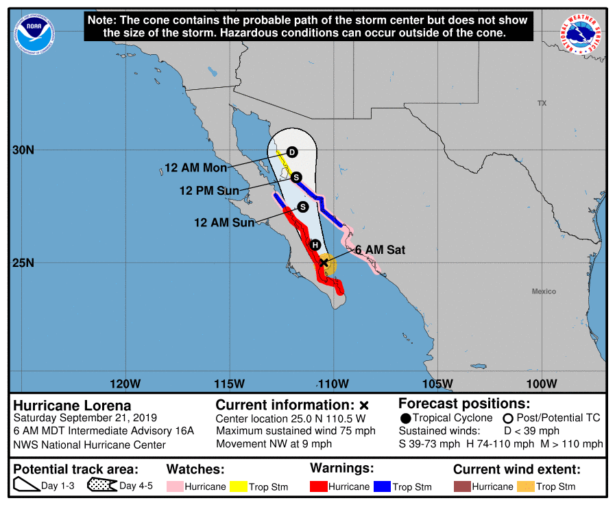
At bottom is NHC forecast for Narda, bringing her up GoC to 30 degrees north by Thursday morning. Current WRF models are forecasting showers and possible thunderstorms our area by Thursday morning. So, our hopes for first October rain will be linked with the evolution of Narda this week.


Friday, September 27, 2019

Closed Low At 500 mb Dragging Its Feet


View from Atmo at about 6:45 am MST this morning, showing buildups growing above the lower clouds. Radar below (from a bit before 7:00 am) shows that storms have developed over western part of Catalinas and to northwest toward Casa Grande. Sprinkles here at house this morning.


Last night from about 10:00 pm to 1:00 am an area of light showers developed and moved across parts of metro. ALERT 24-hour rainfall (above) is through about 7:00 am this morning (there were two reports of 0.04" in southern part of network - not shown). Here at house a locally heavy shower (no thunder) hit about 10:30 pm and left 0.28" in the gauge - a nice surprise. Plot of detected CGs (below from Atmo and Vaisala for 24-hours ending at 1:00 am this morning) shows limited thunderstorm activity yesterday - most active region being far to our west.


This mornings sounding is shown above, with 500 mb chart below (both from SPC). Sounding continues moist and unstable, so current  early showers fit. The 500 mb chart shows that the trough (which had been forecast yesterday to move across Arizona yesterday afternoon and evening) still remains to our west. So a bit of a bust from most forecast models regarding how fast this feature would kick eastward. Feature actually appeared to loop westward, doing a circle, late yesterday - quite something to watch in the water vapor images.


Thursday, September 26, 2019

Dry And Mild After Today


Pre-sunrise view of Catalinas above from Atmo, and stratus streaming over Kitt Peak bottom.


Plot above of detected CG flashes (from Atmo and Vaisala) for 24-hours ending at 5:30 am MST this morning. Most thunderstorm activity yesterday was in western half of state, with little happening in the region of flash flood potential highlighted for eastern Pima and Pinal Counties yesterday.


Rainfall yesterday occurred mostly during early morning hours. Rain here at house totaled 0.23", but only 0.03" of that fell during the day. Plot above shows three day rainfall across parts of ALERT network ending 6:00 am this morning.


The 500 mb closed low has moved over southern California this morning (above and below for 12 UTC from SPC). The low is forecast to open up and move across Arizona during the day today. After that the long-range forecasts are for fair and dry conditions through following six days.


The TWC sounding plot above has PW around an inch, and some CAPE, but warm temperatures in middle-levels. Although official forecast is for 30% POPs across metro area this afternoon, the forecast from the 06 UTC WRF-GFS run at Atmo forecasts only some light showers late afternoon/evening over the Catalinas. Quick check of the forecast soundings from that run show that the warm middle levels are putting a cap on the activity.

For the longer term, the NHC morning outlook below forecasts a tropical disturbance heading toward south end of Baja during the next five days - something to watch.


Wednesday, September 25, 2019

Continued Wet


Periods of showers and some thunder continue to be the story for this week. Catalinas obscured by rain yesterday at 11:00 am MST (above).

Composite radar at 6:53 am this morning (below) shows showers to the south moving toward eastern Pima County.


Yesterday thunderstorms avoided the lower elevations, with recent storms occurring along the western Cochise County line (CG flashes above (from Atmo and Vaisala are for 24-hours ending at 5:53 am this morning).


ALERT rainfall reports (above and below for 24-hours ending at about 7:00 am this morning) show essentially 100 percent areal coverage with numerous reports of greater than an inch, with amounts having distinct east to west gradient. (There are two sites that appear to be out-of-order.)

We had 0.69" here, which pales in comparison to the 2.37" that Art Douglas reported at 6:00 pm yesterday afternoon. Regardless, a very wet day for much of southeastern Arizona.


The 500 mb closed low is off to our west-southwest this morning (analyses above and below from SPC) over GoC and Baja. The low will move northeastward later today and tomorrow, bringing the rainy period to an end by Friday.

Our morning upper-air sounding is nearly saturated (PW of around 1.50 inches). There is still a sliver of CAPE and strong southerly winds through most of troposphere. Looks favorable for continued rainy periods!


Tuesday, September 24, 2019

Thunder And Rain This Morning


Heavy clouds (above) over Tucson at about 6:00 am MST this morning, while Kitt Peak is in the clouds (bottom). Some thunder and light rain currently here at house.


Widespread radar echoes over southeast Arizona at 5:30 am this morning - much as forecast by WRF yesterday. Plot below is of CG flashes for 24-hours ending at about 6:30 am (below) - very active day and night across much of Arizona. There were 10 reports of severe thunderstorms in Arizona yesterday, stretching from east of Tucson out to west-central Arizona long the Colorado River. There was a possible tornado near Willcox that produced 2 injuries.


ALERT 24-hour rainfall amounts for 24-hours ending at 6:00 am (north portion above and south portion below). Seven reports of more than half an inch, with one of those out to southwest of City just over an inch. Here at house we had only 0.08" yesterday evening. More notable rain amounts: Nogales 0.87", Yuma 0.53", TUS 0.42", DM 0.34", and Atmo 0.23".


The morning upper-air sounding at Tucson continues moist with CAPE, and a southwesterly wind profile above 700 mb.


Monday, September 23, 2019

Chance Of Rain Continues - Edited


Post has been edited to add two photos of mammatus taken yesterday afternoon, as thick anvils spread overhead from storms to south-southwest.


Showers south of Kitt Peak yesterday early afternoon.


ALERT shows scattered rainfall reports for 24-hours ending at 5:30 am MST this morning. Only amount greater than half an inch occurred west of Green Valley at Keystone Peak. The airport received 0.39" in an afternoon thunderstorm with gusts to 39 mph. Here at house we had only 0.03" and DM came in at 0.02".

Below is detected CG flashes (from Atmo and Vaisala) for 24-hours ending at 12 UTC (5:00 am) this morning. Thunderstorm activity in eastern Pima County mostly stayed south of Metro area. Ongoing morning storms across central Arizona.


Above figure shows topsy-turvy time series for TUS. Below is the 12 UTC TWC upper-air sounding from this morning. Sounding shows abundant moisture (below 700 mb) and considerable CAPE. Storms should readily form with daytime heating. The sounding profile is actually similar to Plains severe storm profiles, with strongly veering winds below 500 mb.


Large area of state under flash flood watches today and tomorrow (above), as per early morning forecast from NWS (below) for TUS. At bottom is 06 UTC WRF-GFS forecast of composite radar echoes valid at 8:00 am tomorrow morning. The forecast indicates a very large MCS affecting much of southeastern Arizona. 

The morning storms forecast for our area this morning did not materialize, and we'll watch to see what happens tonight.


Sunday, September 22, 2019

Lorena Fizzles


 Skycam on Mt. Lemmon this morning at 5:52 am MST  captures a quarter moon nearly overhead.


Lorena has fallen apart before coming ashore. The storms and rainfall associated with her are shearing off to the northeast across Sonora.


This morning's NWS forecast for TUS (above) indicates some chance of storms through Tuesday, with most likely chances on Monday night.

The longer term 500 mb forecast (below, from 00 UTC GFS) is valid at 12 UTC on the 24th, with a deep closed low over southwestern Arizona. Note that this particular forecast only shows winds forecast to be 30 kts or greater.


The 06 UTC WRF runs from Atmo are interesting. The GFS version forecasts only some popcorn showers over eastern Pima County this afternoon. However, the NAM version forecasts storms this afternoon to south and east, and then forecasts storm thunderstorms approaching metro area at 7:00 am tomorrow morning (below). Very different forecasts from the WRF versions - time will tell.


Saturday, September 21, 2019

Lorena Update


Visible satellite image at 8:00 am MST this morning shows cloud mass with Lorena well up into the GoC.


The uncertainty associated with the movement of Lorena is well illustrated by these two forecasts from NHC this morning. Forecast above is the latest - the remnants of Lorena (a depression) are approaching the Arizona-Sonora border by 6 pm tomorrow afternoon.

The forecast from only three hours earlier (below) had Lorena moving northward considerably more slowly with the remnant depression just south of 30 degrees north at 12 am on Monday.

Quite a change in just three hours!