Monday, November 28, 2022

Cloudy Morning


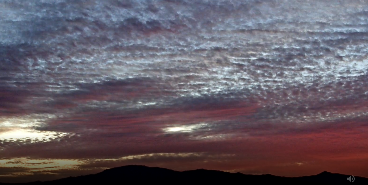
Another pre-sunrise display of red to purple colors over the Rincons at 6:20 am MST this morning.


IR image from 7:40 am this morning shows considerable cloudiness across Arizona, but there should be gradual clearing as day progresses.


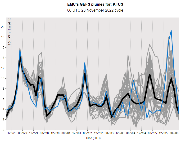
Plumes above are for wind and those below for QPF for coming week - from the 06 UTC runs of the GEFS last night. Models forecast some gusty winds over our area today and over coming weekend. Chances for showers are indicated beginning Saturday and continuing on Sunday. Note the vary large uncertainty in amounts being forecast, with a range from 0.00 to 3.00 inches.

The 06 UTC run of the GFS (bottom) is very aggressive indicating a swath of heavy precipitation across southeast Arizona through 12 UTC on Monday the fifth of December. There has been no precipitation here at the house since 23 October.

Wednesday, November 16, 2022

Quick Update

Pre-sunrise view looking toward the Rincons at about 6:15 am this morning.

As we move into the second half of November, a key question is whether or not we'll have any precipitation for the month. Graphics below show 06 UTC forecasts: first below QPF plumes for coming week from the GEFS, and second below WRF GFS forecast for total precipitation through the end of the month. Models at this time indicate a totally dry month for our part of Arizona.

Sunday, November 13, 2022

Dry, Mild, and Bit Windy


Pre-sunrise color this morning looking toward the Rincons about 6:25 am MST.

GEFS plumes for QPF show little chance for precipitation during the coming week - even the wettest member (red) only indicates about 0.15" next Friday.


Plumes for temperature (above) indicate a bit of cooling tomorrow, but basically a mild week. While plumes for temperature (below) indicate some winds today. The 12 UTC WRF-RR forecast for steady wind speeds (second below) shows 21 kt at 2:30 pm this afternoon. Not much on tap for weather watchers as we reach mid-November with little to report.


Thursday, November 10, 2022

Isolated Showers Yesterday


Sunrise this morning as viewed from San Simon along I-10 east of Tucson.

Frontal passage yesterday was quite distinct - time series of T/Td from Atmo (above) shows the FROPA at around 5:00 pm MST. There were isolated reports of 0.04" around northern portion of the ALERT network (below for 24-hours ending at 6:30 am ). Nothing here at house.


Plumes from the 06 UTC runs of the GEFS (above and below) indicate a quiet week ahead, with perhaps some gusty winds on Sunday. Plumes for wind and PW have huge variance after Sunday.


Wednesday, November 09, 2022

Gusty Winds


View of Catalinas this morning at a bit before 7:00 am MST. Shallow cumulus were hanging over the mountains.

The 12 UTC TWC/TUS sounding (above) continued very dry and very stable. However, there were strong, southwesterly winds below 700 mb.

The 06 UTC run of the WRF-RR forecasts steady wind speeds above 20 kt at the airport at 3:00 pm (above), so gusts of 30 to 35 mph are possible at wind prone locations across the metro. The 500 mb closed low and trough are trending eastward rather than digging sharply into Arizona, as had been forecast the last couple of days (below shows model 500 mb forecast valid at 06 UTC tonight). The forecast for rainfall from the same model run at Atmo (second below) forecasts only an isolated, light shower for eastern Pima County through 5:00 am tomorrow morning.


Finally, the NHC is forecasting Tropical Storm Nicole to intensify to Cat 1 hurricane strength today before it comes ashore near Miami (below).

Monday, November 07, 2022

Cooler Mid-Week


Deep red/purple skies over the Rincons at 6:00 am MST this morning.

A 500 mb short-wave trough over the Northwest this morning is forecast to deepen and cross Arizona on Wednesday. GFS forecast above is valid at 11:00 pm Wednesday night. 

Plumes from the 06 UTC GEFS are shown here. QPF forecasts above indicate slight chance for light showers Wednesday night. Plumes below show members' forecasts for temperature and winds at the airport - again indicating cooler and windy conditions at mid-week.

Over the Atlantic tropical storm Nicole has developed. The NHC forecasts this storm to remain below hurricane strength as it moves eastward, before turning north and curving across Florida. Current forecast is shown below. The eastern Pacific remains quiet.

Friday, November 04, 2022

First Freeze Here


A touch of snow this morning on the ground in Summerhaven.

The snow fell ahead of the sharp trough that moved across Arizona during the past 24-hours. Analysis above is for 12 UTC 250 mb level, showing the very strong jet stream with the trough. Temperatures this morning were the coldest so far this Fall - low temperatures shown across metro area below. Here at house we had our first freeze with the low dropping to 32F.


Two portions of the ALERT network had mostly light precipitation as the trough moved through - one site on the Catalinas had just over half an inch. Here at the house I didn't note any rainfall, but there may have been a light sprinkle which I missed.

Thursday, November 03, 2022

Unsettled Today


Low clouds hanging on the Catalinas at 7:50 am MST this morning.

The TWC/TUS morning sounding (above) has moistened a bit since yesterday, with PW up to 0.59". Most striking aspect of the sounding are the strong southwesterly winds aloft - note the 100 kts (115 mph) just above 500 mb. The 12 UTC WRF-RR forecast for surface wind speeds at 10:00 am this morning is shown below. Model forecasts strong winds over southeast Arizona and most of New Mexico.


Considerable variance among WRF precipitation forecasts for this system, Forecasts here valid through midnight tonight. Above is from 12 UTC WRF-RR with just light showers for parts of the metro area, Below is from 00 UTC WRF-GFS indicating widespread rain for Pima County, with heavier amounts over metro and the mountains; could perhaps yield first rain in my gauge for November.

Current morning forecast from the NWS Forecast Office is shown at the bottom.


Wednesday, November 02, 2022

Gusty Winds Followed By Showers


Have visitors and took a break during the past few days. View above is looking toward the Rincons about 6:00 am MST this morning.

The morning 500 mb analysis (above) shows cold, short-wave over the Northwest. While the TWC/TUS morning sounding (below) shows strong low-level winds near and below 850 mb, with a strong upper-level jet near 200 mb. Sounding is also dry (PW of half an inch) and very stable.


The 12 UTC GFS forecasts the trough to dig sharply south and to be over western Arizona by midnight tomorrow (above).

The 12 UTC WRF-RR forecasts the trough to bring light showers to eastern Pima County (above graphic shows forecast precipitation through midnight tomorrow night). The model run also forecasts strong winds later today - as per wind forecast below valid at 1:00 pm this afternoon.