skip to main |
skip to sidebar
View of Catalinas at about 8:30 am MST this morning shows high-based cumulus field and only a bit of smoke along right side of image.
Forecast above is from the 12 UTC WRF-RR at Atmo and is valid at 5:00 pm tomorrow afternoon. Model forecasts a very nice return of moisture from GoC into southern Arizona.
However, models forecast only slight amounts of precipitation at most. Above is from same model run for precipitation through 5:00 am on July 2nd. The forecast of precipitation below is from 06 UTC GFS and is valid through same period - keeps all precipitation south of border. Apparently warm temperatures in middle levels keep convective activity fairly suppressed - much different than yesterday's forecasts which indicated good chances for decent storms to start July (see previous post).
The forecast plumes for QPF at the airport (bottom) are a mess, and indicate at best a chance for light showers any time from tomorrow afternoon through mid-week next week. Nothing much positive for a wet start to July in any of these forecasts.
Sunrise this morning above - Bighorn fire has burned on off to east of this image. The fire is still less than 50% contained and is burning on east slopes of Catalinas and Redington Pass. Fire conditions will be plagued by strong, gusty winds today and tomorrow.
Wind forecast above is valid at 1:00 pm this afternoon (from the 12 UTC WRF-RR forecast run). The NWS morning outlook for winds today is shown below.
By Wednesday a chance for showers and thunderstorms will be developing as a weak, 500 mb short wave moves from Baja into southeastern Arizona. The WRF-RR forecast above is valid at 12 UTC 1 July. Forecasts below are for composite radar echoes from the same model run: top valid at 4:00 pm MST on the 1st and second valid at 10:00 pm. Forecast for total precipitation through 7:00 am on the second, again from same model run, is at bottom. If forecast verifies, we'll start July with a nice thunderstorm event.
The Bighorn fire has now burned over 100,000 acres of the Catalinas. The fire is almost 50% contained this morning and most growth is on the southeast flank toward the San Pedro river valley. Map above from around midnight last night. View below from 10:32 am MST shows active smoke plume toward far east side of image.
There were thunderstorms in southeast Arizona yesterday, as per plot of detected CGs above (from Atmo and Visala; for 24-hours ending at midnight). Storms were mostly over southern Cochise County, although there was some activity over and near the fire. Rainfall map for past 24-hours ending at 7:00 am this morning (below from MesWest) shows significant amounts just north of the border. Art Douglas reports that he measured 0.97 inches at his place in lower Ash Canyon (near the 0.8" amount). Of course, there was nothing here, although for a while it looked like we might get a sprinkle.
As we head toward the Fourth of July, it appears that things could become more active in our area. The 06 UTC GEFS plumes for QPF at the airport (above) show a wildly variant set of forecast from the ensemble members - both in timing and amounts - but certainly not the flat-line forecast we've been seeing for so long.
Forecast below is from the 06 UTC run of the GFS model and is for rainfall ending at 5:00 am on July 5th. Amounts are light but cover much of eastern Arizona. Something to hopefully look forward to.
Early morning view before sunrise above - some smoke from Bighorn fire right third of image. The fire is approaching 90,000 acres. Down at bottom is south view from Kitt Peak at about the same time, showing heavy clouds and some virga.
Radar forecast above (from 00 UTC WRF-GFS) is valid at 6:00 pm MST this afternoon. Showers and storms brushing east part of metro area. Below is rainfall forecast from same run indicating slight chance for measurable rainfall parts of metro area.
Second below shows 06 UTC plumes for QPF at the airport indicating slight chances today and a bit better by the end of next week. The operational GFS (blue) is a serious outlier on the heavy side. Regardless, things definitely looking up by next weekend.
Biggest concern the next several days will be strong southwesterly winds, which could impact the wildfire situation.
Map above showing current boundaries of the Bighorn fire - fire has grown to over 80,000 acres and has been spreading north and west. It is interesting that a fire crew from Missoula, Montana, has been working to establish fire lines to protect Biosphere 2 from the fires advance.
Models continue with some flip-flopping regarding chances for showers and storms before June comes to an end. All the graphics shown here are from the 00 UTC run of the WRF-GFS at Atmo. Forecast of PW (above) is valid at 6:00 pm MST on Sunday the 28th and indicates a push of values over an inch into southeast Arizona (PW this morning is at 0.57"). Forecast below is of radar echoes valid at 1:00 am on the 28th.
Forecast above is for total precipitation through midnight on the 28th. Amounts are light and mostly at higher elevations. Winds are a concern and current forecasts indicate a period of strong winds Saturday night (below is valid at 3:00 am on morning of the 28th).
Forecast TWC sounding (above for 6:00 pm on 28th)) appears somewhat favorable for afternoon showers and thunderstorms on Sunday afternoon. Note that a warm cap at 450 mb is hinted at - will watch how all this evolves.
Finally, the longer term GFS forecasts indicate that the 500 mb anticyclone will establish itself near the Four Corners by Fourth of July weekend (below is valid at 12 UTC on the Fourth).
At 5:49 am MST this morning (above) smoke from the Bighorn fire was mostly off to east of this view from campus. However, by 7:00 am the smoke had drifted westward and was obscuring all of the Catalinas - photo below looking toward Finger Rock. The fire (current map second below) is currently about a third contained and has burned over 75,000 acres.
Models are wobbling re chances for first summer monsoon storms here. Previous post noted chance for showers around end of June, however, forecasts this early morning have pushed that back about a week into July. Forecast above, from 00 UTC GFS, is for rainfall through 5:00 am on July 1st; that below is from 00 UTC WRF-GFS for same period. I'm really ready for some humidity and storms, since last measurable rain here at house was 0.04" on April 11th.
Views of the Bighorn fire smoke plume a bit after 8:00 am MST this morning - from Summerhaven above and Mt. Bigelow sky cam below. Morning news reports indicate the fire has now burned over 65,000 acres.
Forecast above from NWS this morning - big question is whether high temperature might hit or break 110 F next couple of days.
Below is forecast of composite radar echoes from the 00 UTC run of the WRF-GFS at Atmo - forecast is valid at 11 pm on the 29th. Perhaps a chance for showers as month ends?
The current tropical outlook for the eastern Pacific (from the NHC - below) indicates that the basin will be quite active during next five days. The eastern red area indicates an 80% chance of a depression forming and moving northwest along the Mexican coast. If this does develop, it could help push higher moisture northward up the GoC - so something to watch.
Smoke from the Bighorn fire resulted in a strange, orange sunrise this morning - above and second below.
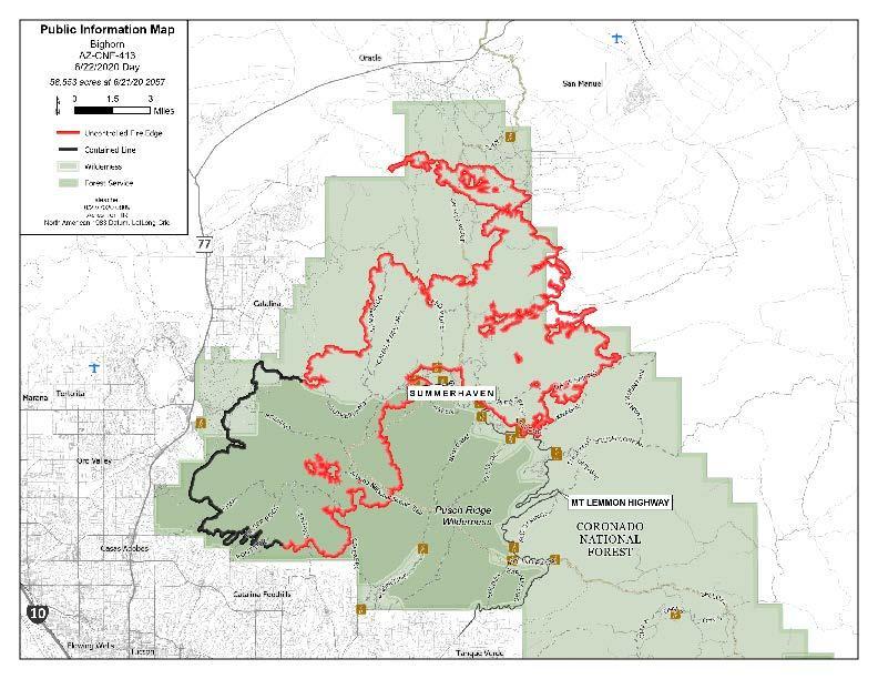
Current map below indicates fire has burned across much of the wilderness and National Forest areas of the Catalinas. Some reports this morning indicate current area burned at over 50,000 acres and that the fire is less than 20% contained.
As for rain hopes - long term model forecasts indicate a start to the summer thunderstorm during the first week in July - fairly typical timing. Shown above is 00 UTC GFS forecast for precipitation through midnight the night of June 30th, with only light amounts for mountains of southeast Arizona. However, by the 7th of July the 500 mb anticyclone (below) is well positioned for moisture return and increased thunderstorm activity. The GFS forecast indicates this in its forecast of total rainfall through midnight on the 6th of July - bottom - which indicates increased storm activity after July 1st.