Wednesday, August 31, 2022

End Of August


Last sunrise of August was quite nice this morning.

Plot of detected CG flashes (below) for 24-hours ending at 0103 am MST this morning shows no activity over Pima and Santa Cruz Counties, and only a few flashes in the far southeast corner of the state (from Atmo and Vaisala). No rainfall occurred across the ALERT network during past 24-hours (note that there is one site reporting bad data in the Catalinas).


At 500 mb this morning (above) the very elongated anticyclone stretches from central California to the Southeast, with its circulation center over the Great Basin. An inverted trough extends from southern Baja to southwest Texas. As this system brushes by tomorrow into Friday, it may bring a chance for showers along the Borderlands.

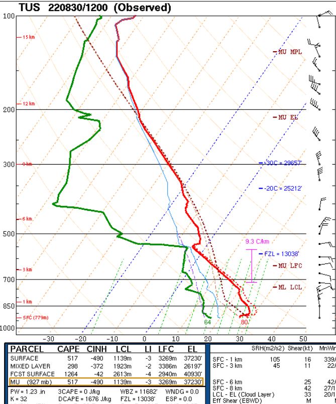
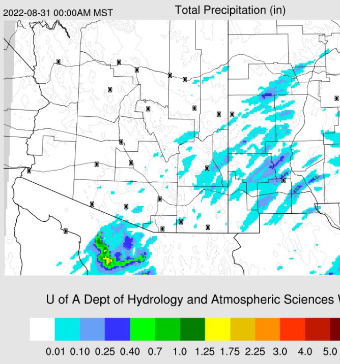
The morning sounding from TWC/TUS (above) is quite dry and stable. Wind speeds aloft are fairly strong through the entire troposphere. The 12 UTC WRF-RR forecast for precipitation through midnight tonight (below) indicates almost no rainfall across the entire state.


It is of interest that both the Atlantic and Pacific are becoming active wrt tropical systems. The NHC outlooks (above and below) indicate high likelihood for several disturbances to develop into storms during the coming five days (above and below).


Tuesday, August 30, 2022

Fair And Dry


Cloudless skies a bit before 9:00 am MST this morning.


As plot of CGs flashes for 24 hours ending at 9:03 UTC this morning (above - from Atmo and Vaisala) shows almost no thunderstorm activity over the entire state yesterday. No rain here or across the ALERT network.

The morning sounding lot for TWC/TUS (below) shows a dry sounding that may have just a sliver of CAPE with a deeply mixed afternoon BL (ignore the lifted parcel analysis since it is not realistic). 


Forecast for rainfall through midnight (above, from 12 UTC WRF-RR) indicates some possible sprinkles over southeast Arizona. Graphic below shows predicted rainfall (from 06 UTC GFS) through the coming week. Not much to look forward to.

Sunday, August 28, 2022

August Winds Down


Hazy skies at about 6:30 am MST this morning.


Only 13 ALERT sites had 0.04" or a bit more during the 24 hours ending at 7:00 am this morning (above) - these were scattered around the network and Arivaca (off map to south) was the 13th site, reporting 0.12". Quite dry here at the house. The plot of detected CG flashes (below from Atmo and Vaisala) during the 24 hours ending at 0753z has a bit of a donut hole centered on the airport.


The 12 UTC WRF-RR forecasts very much reduced activity for the state today (above), but does try to get a couple of storm cells going in Pima and Santa Cruz counties. The forecast for the airport (below from NWS Forecast office) has no mention of storms or rainfall through the coming seven days - but does indicate several days with highs over 100 F.

Saturday, August 27, 2022

Dry-Out To End August


Bit of cloudiness with slight colors over the Catalinas at 5:15 am MST this morning.

Yesterday was quite suppressed with respect to thunderstorms - plot of detected CG flashes (above from Atmo and Vaisala for 24 hours ending at 0103 am MST this early morning) shows our area almost lightning-free with exception of a cell over western Catalinas.

ALERT chart for 24 hours ending at 7:00 am (below) shows that what showers there were concentrated over the Catlinas and Redington Pass. Only two sites in network had a bit more than half an inch - note that not shown on plot are 0.55" at Arivaca and 0.08" near Elephant Head (both in southern part of network). It was dry day here at the house.


The 500 mb level remains a mish-mash, but the morning 250 mb chart (above) shows the upper-tropospheric anticyclone shifted down over southern Sonora, with distinct westerly flow over Arizona.

Morning sounding from TWC/TUS (below) continues moist with potential CAPE, but drying has occurred above 600 mb. The westerly winds aloft are quite unfavorable for storms here.


Forecast above is from the 12 UTC WRF-RR and is for rainfall through midnight tonight - note the distinct donut hole centered near the airport.

As the dry-out continues this week, PW values fall below an inch, which is the lowest level in weeks. Forecast of TPW (below) is from the 00 UTC WRF-GFS and is valid at 7:00 pm on the 29th.

Friday, August 26, 2022

More Showers


Nice view at 6:00 am MST this morning.

There was limited thunderstorm activity in eastern Pima County yesterday as shown by the plot of detected CG flashes above (from Atmo and Vaisala) for the 24 hours ending at 0833 UTC last night.

The ALERT plot below for 24 hours ending at 7:00 am this morning shows scattered sites with 0.04" and greater rain amounts. There were two sites with 0.04" off the map near Green Valley. Heaviest amounts occurred across the southern part of the metro area. The airport reported 0.71" and DM had 0.22". We had only 0.01" here and Atmo reported no rain.

There was one tornado reported in the country yesterday, and that was a brief landspout near the Los Reales Landfill south of the airport.


The 500 mb (above) anticyclone remains very weak and the center continues over northern Mexico. This morning's sounding from TWC/TUS (below) remains very moist and with significant potential CAPE.

Forecast below shows rainfall amounts through midnight tonight forecast by the 06 UTC run of the WRF-GFS - another day with scattered storms around the metro area.


Thursday, August 25, 2022

A Direct Hit


Heavy storm in our part of town around 6:00 pm MST yesterday. Plot of detected CG flashes (below - from Atmo and Vaisala) for 24 hours ending at 0103 am this early morning shows the storms were focused on north part of metro area and the Catalina foothills.


Rain reports were scattered around the ALERT network (above and below for 24 hours ending at 7:00 am this morning. Heaviest amounts were along the Rillito and out to Picture Rocks area west of Tucson Mountains. Here at the house we had a heavy downpour around 6:00 pm that left another 1.36 " in the gauge (total for day 1.39"). This was the heaviest event here in over two years. 

In previous blog post I said that it looked like a down day - but it ended up as a down-pour day. My batting average has not been very good this summer.


The 500 mb chart remains a real mess (above), with no well-defined anticyclone center. In the upper troposphere, however, the anticyclone is very distinct and centered over northern Mexico (250 mb chart below).

The morning sounding for TWC/TUS (below) remains quite moist below 500 mb and unstable. Winds below 400 mb continue light and variable. Once again, I would expect a mostly down day - but after yesterday, I'll just watch to see how things actually go.


Wednesday, August 24, 2022

Severe Storm at Airport


Middle clouds over the metro area at 9:00 am MST this morning.

Scattered reports of more than 0.04" across the ALERT network for 24-hours ending at (;00 am. Most reports were light, with only 5 sites reporting more than half an inch. However, note that the airport and DM had amounts right around an inch. Additionally, the airport reported a gust to 76 mph and there were also reports of poles down. Here at house I estimated gusts to 40 to 50 mph around 6:30 pm. Rain here was only 0.03" (Atmo had 0.02").

Plot of detected CG flashes (second below - from Atmo and Vaisala) for 24-hours ending at 3:03 am this early morning shows storm activity over parts of eastern Pima County.


The 500 mb pattern remains weak over the Southwest (above for 12 UTC this morning), with an anticyclone over the Great Basin and a weak cyclone southeast of Tucson. The 12 UTC TWC/TUS sounding (below) is quite stable after yesterday's storms and today should be a mostly down-day.


Tuesday, August 23, 2022

Another Dry Day Here


Pre-sunrise view of isolated clouds over the Catalinas.

Plot of detected CG flashes (above, from Atmo and Vaisala) through 0703 UTC (1203 am) today - thunderstorm activity increased relative to Sunday, but remained east of most of the metro area.  Plot from ALERT network (below) shows only some scattered reports, but with a cluster of heavy reports in the southeast corner of the network. It was another dry day here at the house.


The morning sounding from TWC/TUS terminated early, and is shown above. If the BL mixes out to 700 mb, there is considerable CAPE. The wind profile shows increased southwesterly speeds above 300 mb, but with light easterly winds below 500 mb. Thunderstorms that develop this afternoon will probably be outflow driven - but any storms southwest of the metro will send their anvils overhead.

The 06 UTC WRF-GFS forecast from Atmo (above) forecasts significant rainfall by midnight for much of the metro area. However, the 12 UTC run of the WRF-HRRR (below) forecasts more isolated and lighter amounts around eastern Pima County. Another day where the actual outcomes are hard to anticipate.

 The NWS graphic this morning (second below) provides yet another possible distribution of storms later today - note the POPs are hard to see but that at Tucson is 46 percent.