Friday, February 25, 2022

Cold Morning Here


Sunrise this morning from Sahuarita (above) and from San Simon (bottom).


The 06 UTC runs of the GEFS show little on the horizon as we head toward March - above the plumes for QPF are flat-lined, and below temperature and wind plumes show mainly slowly warming temperatures and generally light winds.

The low here at house this morning dropped to 26 F, so it was pretty cold when I ventured out to pick up the paper.

The 6 to 10 day outlooks ( from NOAA Climate Prediction Center) continued warm temperatures and dry conditions here in the Southwest from March 2nd to 6th.


Thursday, February 24, 2022

Brief Summary Of Event


Morning views: above on Mt. Lemmon near Ski Valley, and bottom shows the San Francisco Peaks from Flagstaff. 

Time series from Atmo above (T and Td) shows the very strong frontal passage that occurred around 3:00 pm MST, with a temperature drop of more than 20 F in just a few minutes. Plot below (from MesoWest) shows 24-hour precipitation amounts for metro area. Heavier amounts avoided the main part of the city. 

Most observation sites across southeast Arizona reported strong winds with gusts generally running 45 to 60 mph - strongest I saw was 66 mph at the exposed Guthrie RAWS station.

Here at the house I estimated gusts around 40 to 50 mph, along with 0.11" of cold rain.

Looks like rest of month will feature a gradual warm-up with little chance for any more precipitation here.


Wednesday, February 23, 2022

Showers Late Afternoon

Views around 8:00 am this morning: above shows Catalinas with low clouds hanging on mountains; bottom views are of Flagstaff and of AZ Snowbowl, where it is snowing heavily at both places.

Numerous weather hazards and warnings today (above) for much of the Southwest. Current NWS forecast for Tucson is for gusty winds to near 40 mph this afternoon and some blowing dust; with 80% POPs for rain at airport late afternoon into the night, and a low tonight around freezing. Driving could become hazardous on Highway 83 south toward Sonoita tonight, since there'll be some snow accumulation down that way.


Three forecasts here are from the 12 UTC WRF-RR forecast at Atmo. Above shows forecast steady wind speed valid at 4:00 pm this afternoon. Below shows forecast radar echoes valid at 6:00 pm this afternoon, and second below shows total precipitation forecast through 6:00 am tomorrow morning.

Weather situation has evolved essentially as has been forecast by the models during past few days - see earlier posts.


Monday, February 21, 2022

Big Changes Mid-Week


Beautiful, clear skies  at mid-morning today.
 

However, a strong, 500 mb short wave will be digging into the Southwest by Wednesday - 12 UTC GFS forecast above is valid at 00 UTC on the 24th.

This feature will bring chances for precipitation at the airport, as per 12 UTC GEFS forecasts. Plumes above for QPF, below for wind, and second below for temperature (note the strongly falling temperatures on Wednesday!).


Forecast above is for total precipitation through midnight on the 23rd (from the 12 UTC WRF-RR runs at Atmo. Heaviest amounts stay mostly north of Tucson, except for higher elevations. The current morning forecast from Tucson NWS is shown below - with a mention of possible snow on Wednesday night. That would be some change from our current mild and dry conditions!


Thursday, February 17, 2022

Yesterday's Showers

Cumulus hanging over the Catalinas at about 11:30 am MST this late morning.

Showers yesterday were fairly widespread, but amounts were light. The ALERT reports of amounts (above and below) indicate many sites had amounts less than 0.04" - ALERT plots only amounts of 0.04" or greater. Amounts were higher across the southern part of the network.

Here at house we had 0.03". Measurable, but barley enough to wet the courtyard. It was however, the first rain in more than three weeks. 

Wednesday, February 16, 2022

Continued Unsettled


Chaotic skies this morning with dark clouds, some blue sky, and muted sunshine on campus.

At 500 mb this morning (above) a sharp trough to the west is about to cross over Yuma (analysis from NOAA indicates a closed low out there but if it was, it is opening quickly). The 06 UTC GFS forecast below (valid at 18 UTC today) indicates the strong trough approaching our area.


The TWC/TUS sounding this morning (above) was quite dry - PW of only 0.32" - with strong southwest winds aloft. In contrast, Yuma's sounding at 12 UTC (below) was more moist (PW almost half an inch) - note the very low tropopause around 500 mb and the westerly winds below. 


Shower activity was approaching the metro area from the southwest at 7:40 am MST (above), and the 06 UTC WRF-GFS forecasts two lines of echoes moving across southeast Arizona at 11:00 am, later this morning.

Big question here at house is whether there'll be measurable rain in gauge at end of day.

Tuesday, February 15, 2022

Windy Today


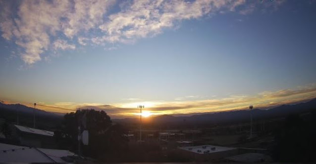
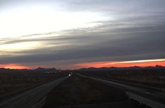
Campus deserted early this morning (above), and sun and shadows over Bisbee at 7:20 am MST this morning (bottom).


Current morning forecast from NWS Tucson Forecast Office (above) indicates winds, dust, and high fire dangers today, followed by slight chances for rain showers into Wednesday morning. The NWS forecast calls for gusts today reaching around 40 mph, while the WRF forecasts steady speeds of around 35 mph during mid-day. Trash bins and other loose objects may blow over or around - take care driving. 

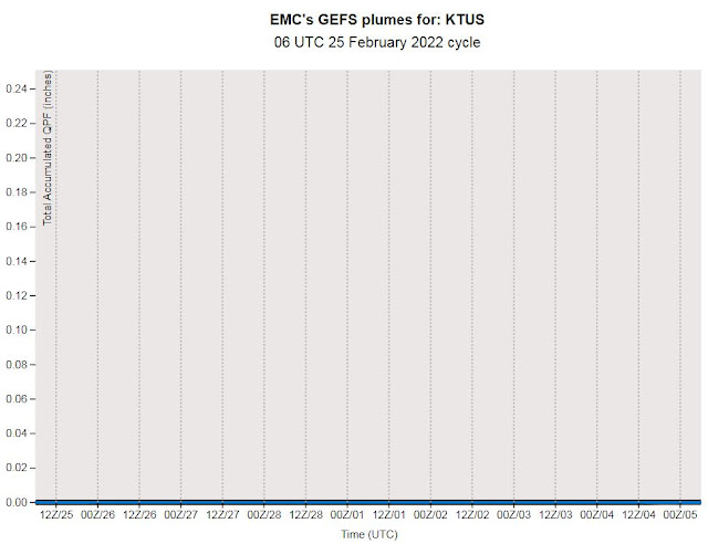
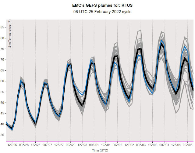
The plumes for QPF (above from 06 UTC GEFS) show all members forecasting measurable rainfall at the airport late tonight and tomorrow morning. Plumes also indicate possibility of a more significant event around next Tuesday, but that's a week away. Plumes for temperature (below) indicate a bit of a roller coaster ride during the next seven days, with a couple of very chilly days indicated.

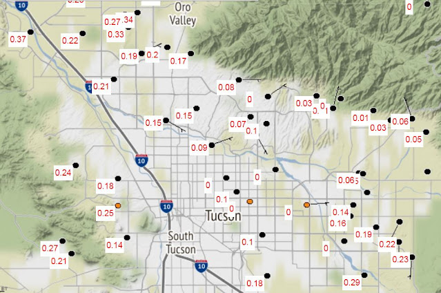
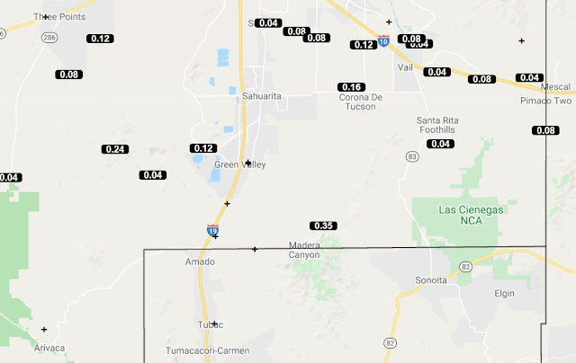
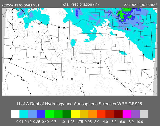
Second below shows 06 UTC WRF-GFS precipitation forecast through 6:00 pm tomorrow evening - indicating widespread, but quite light precipitation. Looks like a couple of interesting days, after mostly clear skies since the 23rd of January, when there was 0.02" of rain here at house.


Saturday, February 12, 2022

Dry Into Next Week


Pre-sunrise views about 6:30 am MST this morning - above from Sahaurita and bottom from San Simon.

Current forecast from NWS Tucson this morning (above) - breezy on next Tuesday and slight chance for showers Tuesday night and Wednesday.

Plumes for QPF at airport (above from 06 UTC GEFS) indicate slight chances for showers late Tuesday and on Wednesday. Forecast below (from 06 UTC WRF-GFS run at Atmo) is for total precipitation valid through midnight next Friday night. That forecasts indicates little precipitation for Arizona, and nothing across southern half of state.


However, the same run of the GEFS members for wind (above) indicates a very windy day at the airport next Tuesday (the 15th). The WRF-GFS forecast (below - valid at 2:30 pm on the 15th) also indicates a windy day.  

Depending on your models of choice, we can look ahead for winds at mid-week, and perhaps some light showers.


Wednesday, February 09, 2022

Mild Temperatures/Some Winds


Early morning views of: the Catalinas from campus (above at 7:25 am MST); Mt. Lemmon SkyCenter (second from bottom at 7:20 am); and of Puerto Penasco (bottom at 7:00 am).

The next significant short-wave that will impact Arizona approaches the state at 12 UTC on February 16th (as per GFS forecast above from 06 UTC run). Temperatures until then will be quite mild, mostly in 70s, reaching near 80 F on a day or two. Precipitation forecast from same GFS run (below) shows that the system will likely be moisture starved.


Forecasts here from 06 UTC WRF-GFS run at Atmo. Above shows little total precipitation through 10:30 am on February 16th across entire state. While there will be several breezy to windy periods during next seven days, the same run of the WRF indicates that the winds will be very strong on the afternoon of the 15th (next Tuesday). Note that 31 kts converts to 36 mph.