Monday, May 29, 2023

Memorial Day 2023


Jupiter is now very high in the morning sky at 5:00 am MST.


Memorial Day is usually considered as the unofficial start of summer. Shown here are the seasonal outlooks (from NWS Climate Prediction Center) for temperature (above) and precipitation (below). Our area is forecast to continue warm to hot and very dry. 

Thursday, May 25, 2023

Very Warm And Dry


Jupiter is still dominating the earl morning, eastern sky - view above, looking toward the Rincons, is from 0425 am MST. The rest of May will end here with highs in the 90s F and morning lows around 60 F, while continuing very dry.


Conditions continue very dry over the western US as per image showing TPW analysis from 7:00 am this morning (above). Plot of CG flashes below (for 24-hours ending at 0113 am this morning) indicates no CG flashes were detected over all of Arizona and western New Mexico. Forecast from 06 UTC GFS run (second below) is for total precipitation through 06 UTC on June 1st.


Out in the west Pacific, a satellite view of Super Typhoon Mawar (below) at 12 UTC this morning shows the storm's spectacular eye. The storm struck Guam late yesterday, doing significant damage. The storm currently has peak gusts over 200 mph.

Monday, May 22, 2023

Limited Thunderstorm Activity


Scattered high clouds over the Catalinas at about 5:15 am MST this morning. Down at bottom is view of Rincons and Jupiter rising about 4:15 am.

Most of Arizona had almost no thunderstorm activity, except along the northern border - plot of detected CG flashes (above - from Atmo and Vaisala) is for 24-hours ending at 0133 am this morning.

The dry-out continues through the rest of the month, as typical May weather returns. Forecast above is from 06 UTC WRF-GFS and is for total precipitation through 5:00 am on the 29th. Below is GFS forecast for total precipitation through 0600 UTC on June 1st.


Saturday, May 20, 2023

Dry Out


Yesterday was very suppressed, as the large scale returns toward more normal hot and dry May conditions. View of flat cumulus over the Catalinas is from yesterday at 3:30 pm MST.


Plot of detected CG flashes (above from Atmo and Vaisala) is for 24-hours ending at 0103 am this early morning. Very few thunderstorms occurred over southeastern Arizona, with no storm activity across entire metro area.


ALERT (above) and MesoWest (below) show just a couple of rainfall reports, and these occurred in the early morning hours just after midnight yesterday.


Forecast below (from the 12 UTC WRF-RR) is for precipitation through 6:00 am tomorrow morning and indicates a very quiet day for much of Arizona, with almost nothing forecast for all of southeast Arizona.

Friday, May 19, 2023

Widespread Rainfall Yesterday


Showers along the foothills at 5:45 pm yesterday afternoon. Plot of detected CG flashes (below from Atmo and Vaisala) for 24-hours ending 1:03 am this morning shows thunderstorm activity occurred across northeast Pima County.


ALERT reports (above and below) indicate widespread rainfall with only eight sites not receiving 0.04" or more - heaviest amounts occurred out west of Picture Rocks area. Here at the house we had thunder, wind gusts around 30 mph, but only 0.07" of rain.


The TWC sounding this morning (above) has considerable mixed-layer CAPE, but substantial low-level heating will be needed for storms at low elevations. Winds aloft continue light and variable. The 12 UTC run of the WRF-RR does forecast rain across most of the metro area through midnight tonight (below).

Thursday, May 18, 2023

May Showers Continue


View of somewhat chaotic skies at 5:45 am MST this morning.

Yesterday was another day with unusual May showers and thunderstorms. Plot above shows detected CG flashes through midnight last night (from Atmo and Vaisala), with activity focused in our corner of Pima County. Rainfall was much more widespread than yesterday's predictions - see previous post. Activity again exceeded my expectations, based on the morning sounding.

Rainfall amounts from the ALERT network (below - for 24 hours ending at 6:30 am) show some spots got a bit over a quarter of an inch. Here at house we had 0.10" around 8:00 to 9:00 pm. I didn't hear any thunder, but the CG plot indicates there may have been some.


This morning's sounding (above) is similar to last two days, with the exception of rain cooled layer near the surface. Deep, mixed layer CAPE is again just a sliver. However, the 09 UTC WRF-RR forecast from Atmo (below) indicates a much more active day. Note the 0.40" predicted for the airport.

Second below shows the 06 UTC WRF-RR forecast for PW, which is indicated to decrease dramatically after today, and bring us more typical dry conditions for May.


Wednesday, May 17, 2023

Light Showers


Great color over the Rincons at 5:30 am MST this morning. View from campus at 3:45 pm yesterday (down at bottom) shows showers along the foothills.

I didn't think that yesterday morning's sounding looked favorable for storms, but we had two crashes of thunder and light showers here between 3:30 and 3:50 pm. Total rain here was only 0.03". The plot of detected CG flashes (above for 24-hours ending at 11:30 pm yesterday night - from ATMO and Vaisala - shows a donut hole over much of eastern Pima County, but also some flashes along the foothills. 

The ALERT network rainfall reports (below) show light rain amounts scattered across the northwestern metro area and the Catalinas. Heaviest reports, though, were down to the southwest where Altar Wash had 0.63" and Arivaca reported 0.43".


Today's morning sounding (above) looks as bad as yesterday's, with just a sliver of CAPE and mostly light/variable winds aloft. The 06 UTC forecast (from the WRF-GFS - below) indicates only light showers over the Catalinas and Rincons through midnight tonight - which fits well with the morning sounding. But, once again, time will tell.


Tuesday, May 16, 2023

Isolated Showers Yesterday


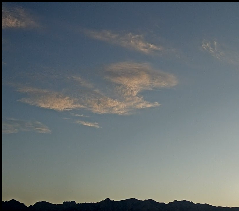
View toward Rincons at 5:15 am MST this morning shows pre-sunrise colors, plus the waning, crescent moon.

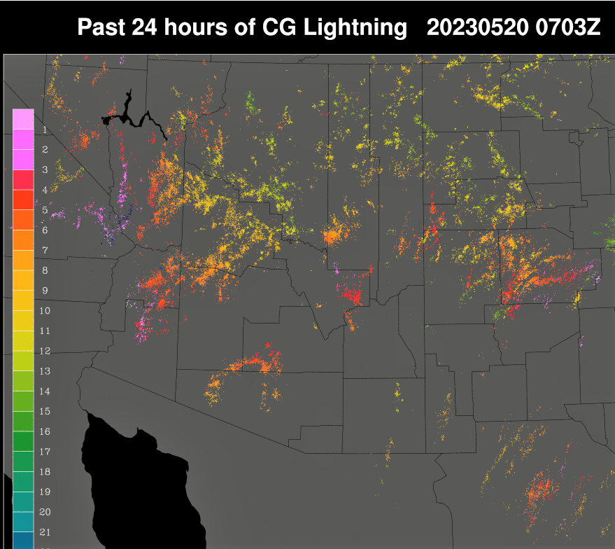
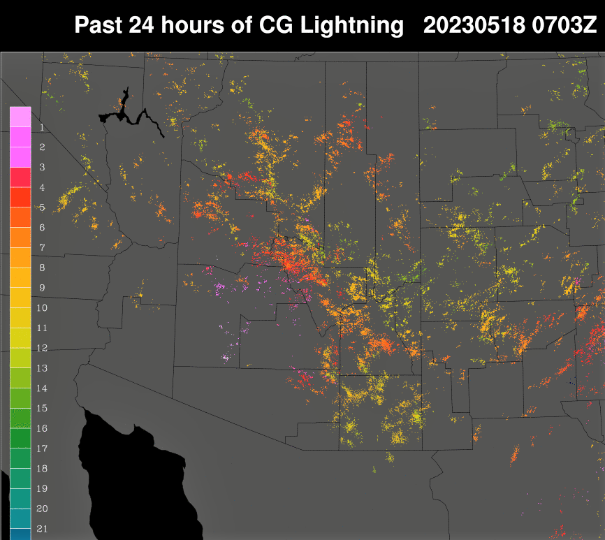
Plot of detected CG flashes (from Atmo and Vaisala) for 24-hours ending at 1:03 am this morning (above) shows that all of the southwestern half of Arizona was almost totally suppressed yesterday wrt thunderstorms. I had thought that storms might develop over the mountains, but this didn't happen, except in Cochise County.

There were a couple of light, afternoon showers that moved across parts of the metro area. It's possible we had a sprinkle here, but if so, I didn't notice it.

Plots of 24-hour hour precipitation (above from ALERT and below from MesoWest) for 24-hours ending at 7:00 am show isolated, light rainfall amounts.


The morning 500 mb analysis (above from SPC) shows an elongated, very weak anticyclone over the Southwest. Height gradients are weak, with only one contour crossing the entire West.

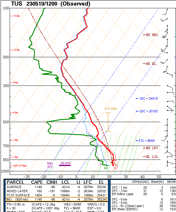
The morning sounding from TWC/TUS is again very stable, with a deep, old boundary layer (BL) and at best a sliver of Cape. Winds aloft are very light through the entire troposphere.

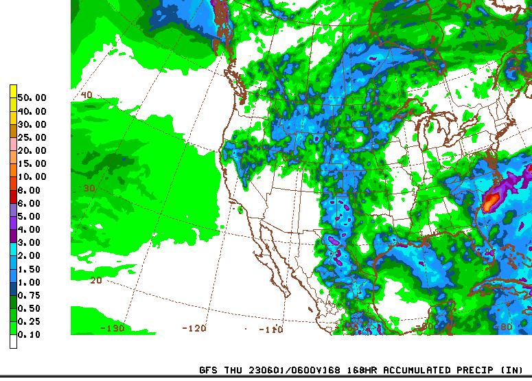
 Looks like another day where it will hard to get thunderstorms going. However, the 12 UTC WRF-RR forecast for rainfall through 6:00 am tomorrow morning (below) predicts widespread, but light showers for most of eastern Pima County. This may be over-done given the morning sounding. Time will tell.

Monday, May 15, 2023

Light Showers With Strong Winds


Mammatus overhead yesterday at 3:50 pm MST.

Plot of detected CG flashes for 24-hours ending at 0830 UTC (1:30 am) this morning (below) shows that several thunderstorms occurred over eastern Pima county yesterday afternoon. There was a light shower here that produced gusty winds (30 to 40 mph) and 0.01" of rain - first in gauge since March 22nd. The airport reported thunder and gusts to 45 mph with a Trace and DM reported gusts to 53 mph. There were reports of a power pole and a tree down near DM.


The morning sounding from TWC/TUS (above) is fairly stable with winds less than 30 kt at all levels. Any storms today will likely stay on the higher elevations.


The 500 mb pattern (above is GFS forecast valid at 5:00 pm this afternoon) is very summer-like, with a weak anticyclone centered off to our northeast. The precipitation forecast from the 12 UTC WRF-RR (below) keeps the metro area dry through 6:00 am tomorrow morning.

Sunday, May 14, 2023

Windy Morning


Wispy clouds over the Catalinas this morning at 7:15 am MST. 

It's a windy morning - airport has reported gusts as high as 32 mph from the east this morning.

The 12 UTC WRF-RR forecasts for steady wind speeds at 8:00 am this morning (above), and for 8:30 pm below. Winds diminish later this morning, but then there is a threat for gusty outflows from evening storms to our southeast.


The QPF plumes from the 06 UTC GEFS runs (above) indicate a slight chance for very light showers at the airport this evening. The forecast for precipitation (from the 12 UTC WRF-RR) through 6:am tomorrow morning is similar. The WRF forecast for CG activity (at bottom) indicates that there will be isolated thunderstorms in eastern Pima County at 1:30 pm today.  Note that strong east winds are hostile for storms in metro area, so they will need to weaken considerable during next couple of hours.