Saturday, October 31, 2020

Halloween 2020


Halloween comes with a rare blue moon this year.


Thursday, October 29, 2020

Zeta Status/Long-Term Outlook Here

Rainy skies at Blackburg, Virginia, as tropical storm Zeta approaches - Zeta produced significant damage last evening as its eye moved across New Orleans.

Current NHC forecast for Zeta below.


Surface map for 14 UTC this morning above, and concurrent IR satellite image below. Heavy rains for Washington DC today.


Out here in the Southwest, clear rain-free skies continue, and GFS outlook above for precipitation through the first week in November indicates little change. Our September/October drought continues into November.

Wednesday, October 28, 2020

Zeta Tracks Toward New Orleans

First, another chilly morning here at house with a low of 34 F, versus about 39 or 40 at the airport.

Rainy skies above at New Orleans as hurricane Zeta approaches - Zeta below in visible satellite image from 1431 UTC this morning.


Current forecast track for Zeta above from NHC, which estimates that the storm will come ashore with max winds around 80 to 85 kt (about 90 to 100 mph).

Below are two more satellite images in the long wave and short wave IR bands.


Tuesday, October 27, 2020

Coldest Morning Here Since Late March


Heavy clouds this morning on parts of the Catalinas. Image at bottom is of main street in Silver City, New Mexico, where it appears they've had a touch of light snow.


Main weather story this morning is the cold temperatures - lows this morning more than 20 F colder than yesterday's. Temperatures above and below are from MesoWest at about 6:50 am MST. Low temperature here at house reached 33 F - the coldest low since March 28th, which had 31 F.


The 500 mb low is nearly over head this morning - pretty much as has been forecast for the past few days. The observed wind for TWC at 500 mb was 350/12, so low center is a bit further east than indicated on the analysis above.

As the low moves eastward today and tonight there are a wide variety of watches and warnings in effect, as per graphic below. Most of New Mexico and northwest Texas are under a Winter Storm Warning. Forecasts indicate about 2 to 4 inches of snow likely in Albuquerque, but around a foot out in the Plains at Clovis.

Zeta hit Yucatan last night as hurricane and has now weakened as it moved into the Gulf of Mexico (GoM), but it is expected to intensify. The storm will approach southeast Louisiana as a Cat. 1 hurricane tomorrow afternoon (as per current NHC forecasts).


The morning sounding at TWC (above, from Univ. of Wyoming weather page) is quite interesting. Appears to me that the tropopause is very low and located around 500 mb.

Forecast plumes of temperature (below, from GEFS ensemble forecasts at 06 UTC) indicate a very rapid warm up - current NWS forecast indicates high temperatures reaching to near 90 F by the weekend. So, it appears our cool spell will be short-lived.

Monday, October 26, 2020

Light Showers This Morning


Morning showers along the foothills at about 7:15 am MST and some snow on the San Francisco Peaks at bottom. Morning lows here only in low 60s F, but forecast to be around freezing next couple of mornings.                                      

Light showers have been moving across parts of the metro this morning, and a few locations have received measurable, light rainfall amounts (as per reports from MesoWest for 24-hours ending at 8:45 am - above). Showers here so far have just wet the patio, and left only a Trace in the gauge.


Morning sounding (above) indicates a bit of low-level moisture and CAPE, which has supported the showers. The 500 mb short wave is over northwest Arizona this morning and is forecast to close off and move south-southeastward - forecast below is from the 06 UTC GFS and is valid at noon tomorrow.

Meanwhile, tropical storm Zeta is located southeast of Yucatan, and is forecast to move across the GoM, intensify to hurricane strength, and move toward southeastern Louisiana.


Sunday, October 25, 2020

Much Cooler With Some Chance Light Showers


Purple skies before sunrise this morning at about 6:00 am MST, but some green to yellow hues at about the same time south of Kitt peak (bottom).

An IR satellite image at 0711 am (below) shows cloudiness across the southeastern half of Arizona, extending westward across northern Baja.


At 500 mb at 12 UTC this morning (above) there is a weak showrt wave across southern California, while the main short wave is to the north, across Idaho to northern California. In forecast below (from 06 UTC GFS - valid at 12 UTC on Tuesday the 27th), the southern short wave has vanished, while the main system has dug south-southeastward and is centered to our east over the New Mexico boot heel.

The GFS forecast for precipitation from same run and ending at same time (second below), keeps the meaningful rain well to our northeast.


The digging wave brings some chances of light showers at the airport - above SREF plumes (from the SPC site) show several heavier outliers, but most members forecast amounts at airport ranging 0.00" to about 0.30". Because the system is quite moisture-starved, I favor the runs that keep rainfall light to a Trace.

Main impacts of this event will be gusty winds beginning later today and extending into Monday, with much cooler temperatures. Perhaps the occurrence of lows near, or below freezing, will occur here at house by midweek.


Saturday, October 24, 2020

Slight Chance For October Rain Here

At last, some clouds in the morning skies! - below, over the Catalinas a bit before sunrise, and pink skies south of Kitt Peak about same time (bottom).

The 06 UTC GFS analysis for 500 mb (above) shows a large, broad trough over the U.S. and Canada, with a weaker short wave southwest of California. The GFS forecast (below, valid at 11:00 am 27 October)) from same run indicates the weaker short wave will minor out across northern Mexico, while the main trough digs southward across Arizona. Forecast indicates main trough situated just out to the west of Tucson. at mid-day on Tuesday.

The GEFS plumes from 06 UTC last night forecast a chance for light precipitation on Monday or Monday night. Amounts in the forecasts are light ranging 0.00" to about 0.25". Given our extreme dryness of the past 55 days, any rainfall here would be much appreciated.


Two forecasts here for total precipitation through 11:00 am on next Tuesday - above is from 06 UTC GFS, and below from 06 UTC run of the WRF-GFS at Atmo. Neither of those model runs forecasts much action for our part of Southeast Arizona. Will watch to see how this situation evolves over next couple of days, but definitely windy tomorrow and Monday, as well as much cooler Monday through Wednesday.


Monday, October 19, 2020

Strange Sounding Last Evening

The upper-air sounding taken late yesterday (release time around 4:00 pm MST) looks very strange in the skew-T plot above (from SPC). Very low temperatures and dewpoint at surface (62  and -3 F) are too cold and obviously in error. Readings at the airport at 4:00 pm were 92 and 18 F. Something went awry somehow, and whatever quality control procedures there are missed the very bad data.

Shown below are the actual sounding data and the skew-T plot from Univ. of Wyoming. After all the very hot weather this month, 62 F at 4:00 pm yesterday would have been very welcome.


Sunday, October 18, 2020

Dry Rest Of Month

Clear skies continue over southeastern Arizona this morning, although there may be a bit of smoke visible at east side of 8:00 am MST image above. The view north from Kitt Peak at same time (bottom) shows layer of smoke along the northern horizon - not obvious what fire this is from (there are many fires burning, but this could be from the Horse fire near Crown Point southeast of Prescott).             

Forecast above from 06 UTC run of the GFS model is for total precipitation through Halloween night at midnight - continued VERY grim for the Southwest. If forecast verifies, October will be second straight month with nothing in the rain gauge here.


Tuesday, October 13, 2020

Drought Goes Into Mid-October


 Clear and dry skies continue over southeast Arizona this morning. Image at bottom shows Orion from the Big Island last Monday.

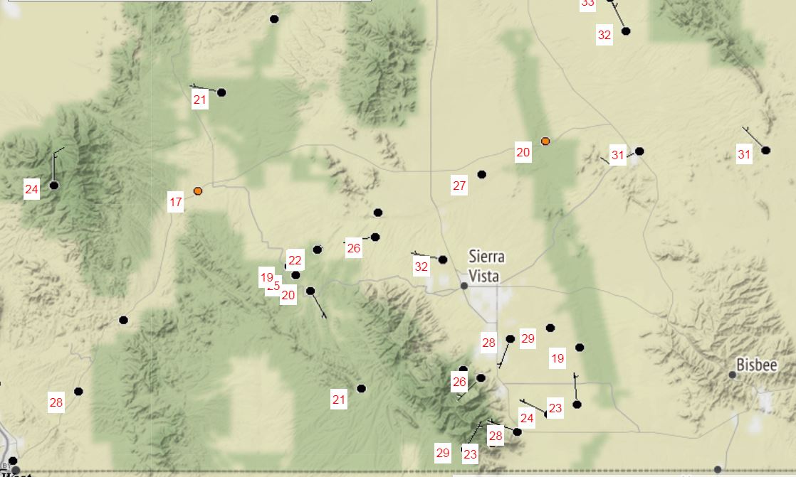
The last measurable precipitation here at the house was on 31 August - amount was 0.02". This the 43rd day without rainfall.

The forecast below (from the 00 UTC WRF-GFS run at Atmo) is for precipitation through 5:00 pm MST on the 20th of October. Longer range forecasts indicate that October may well end up with zero precipitation.