Sunday, February 28, 2021

Forecast - More Winds


 Unwrapped SkyCenter view on Mt. Lemon about 6:30 am MST this morning - note the waning, but nearly full moon at the trees on right.

Bottom is west view of lights of Denver, with moon over city but behind thin, high clouds.

Below is this morning's forecast from NWS for next three days - wind, wind, and more wind.


Forecasts here are from 06 UTC WRF-GFS for 10-m winds: above is valid at 4:00 pm today, indicating strong northwesterly winds; below is for 10:00 am tomorrow, showing a switch to gusty winds from the east. The strong east winds continue on Tuesday morning, but shift northward and weaken some - second below. 
Forecast models do indicate some chances for light showers by late Wednesday.


Saturday, February 27, 2021

Meteorological Winter

Bit of pink color on high clouds over the Catalinas before sunrise this morning. At bottom is west view toward Denver, with the full moon visible behind high overcast. 

Tomorrow is the last day of meteorological winter (December, January, and February), and it looks like winter's end will be very blustery, and of course dry - as February bows out with no rainfall here. 

Colorful hazards map this morning (above) - what really caught my eye was the very large area of country under a flash flood watch. The gray area was for dense, early morning fog. Note that portions of southeast Arizona (below) are under a fire weather watch that is valid tomorrow, when gusty winds will combine with very low relative humidity.


The GEFS forecast for winds (above from 06 UTC runs) indicates several windy periods during the coming week - with strongest winds currently forecast for tomorrow. The 06 UTC WRF-GFS forecast for winds at 2:00 pm MST tomorrow (below) actually indicates strongest winds over Cochise County, northeastern Mexico and southwest New Mexico.


Friday, February 26, 2021

February Winds Down/Large Fire In LA

View above this morning just after sunrise, shows a bit of dirty air over Tucson - probably dust from the winds of past several days. View below is of Bisbee at about the same time.

Down at bottom are views of a large smoke plume seen from LAX airport - the fire is in an industrial complex in Compton area. There were a large number of buses caught in the blaze.


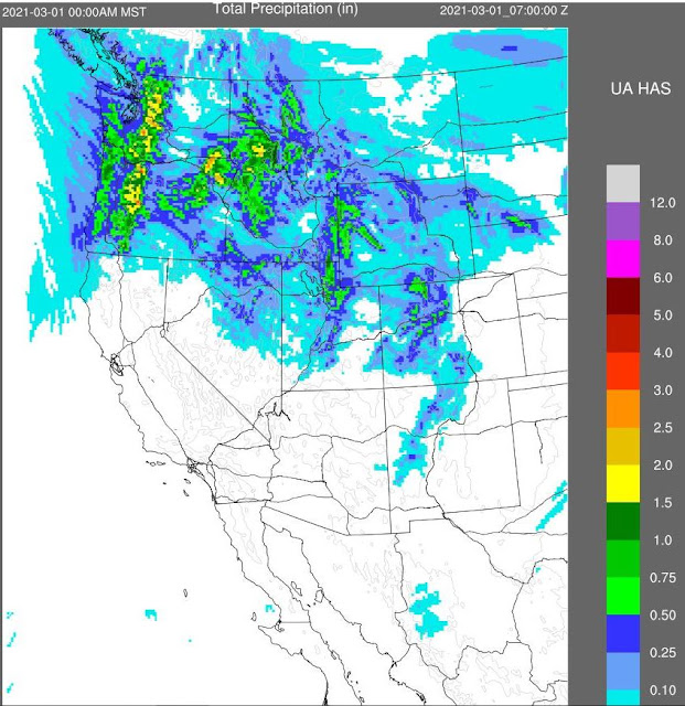
Forecast above is from the 06 UTC WRF-GFS and is for precipitation through 00 UTC on March 1st - the Southwest is mostly dry through the rest of the month, as is the Tucson area.

 The plumes below show mild temperatures continuing into March, as well as a couple of windy days - especially this Sunday afternoon. Big question now is: when will March bring us some rain?


Monday, February 22, 2021

Dry February Continues

Cloudless skies continue as we head toward end of month. Below - sunrise reflections off Denver buildings this morning, as well as cap cloud on mountains and lenticulars above.

Down at bottom are views of: the Paria Plateau and Colorado River cut looking north from Utah border; Lake Tahoe; and Turpin Meadow Ranch, just south of Yellowstone NP.


This morning's forecasts offer little hope for any rain here during rest of month. Forecast above from the 06 UTC WRF-GFS valid through 5:00 pm on this Thursday the 25th, while 06 UTC GFS forecast below valid through 5:00 pm MST on February 28th.


Saturday, February 20, 2021

Clear Skies Continue

 Clear skies above in the north view from Kitt Peak this morning. Little on the weather front here, except for some gusty winds this afternoon.

View of downtown Kansas City this morning before sunrise - sea shell like building right side is the Kauffman Center for the Performing Arts. Image below shows hardy couple jogging in the rain at Aberdeen, Scotland, today.

Down at bottom are views of the Grand Targhee Resort's stick of truth yesterday morning and then this morning. Obviously plenty of new snow up there - not sure whether the board was cleared yesterday or not, but looking at building in background it appears as if the new accumulation was not much.

Forecast from the 06 UTC GEFS (above) for 10-m wind speeds indicates windy day today, as does the 06 UTC WRF-GFS wind speed forecast for 3:00 pm MST this afternoon (below).


Thursday, February 18, 2021

Look Through End Of Month


Clear skies prevail this morning. Yesterday brought very chilly winds again, and hopefully things will be more calm today and tomorrow.

Down at bottom is view of the light pylons at LAX during daytime.

The current NWS forecast above is for a rapid warm up after today, with temperatures reaching to around 80 F by Saturday.


The GFS outlook for precipitation for rest of February (above through 06 UTC on March 1st) remains grim for most of the Southwest - looks like February may close out with no measurable precipitation in our area. The seasonal drought outlook (below) is equally grim for most of the West out through the end of April.


Tuesday, February 16, 2021

Missed Again

Heavy clouds over Catalinas this morning. Image down at bottom is of downtown Albuquerque at 6:30 am MST, when significant snowfall was occurring.

Yesterday's WRF forecast prevailed again, with precipitation remaining far to north and east of metro Tucson. Only precipitation I saw reported in southeast Arizona was 0.01" at Elfrida over in Cochise County. The visible satellite image below (from a bit after 8:00 am) shows heavy clouds covering the northeastern 2/3rds of Arizona and almost all of New Mexico. There are some light showers off to our north and east this morning.


The 06 UTC GEFS members are still trying to forecast precipitation at the airport today, but the WRF continues to forecast no precipitation for low elevations in the metro area, although some very light showers are forecast for the mountains this afternoon.

The 12 UTC 250 mb chart below shows very strong jetstream approaching Arizona today. primary impact from the strong winds aloft will be gusty winds off and on today and tomorrow. Looks like chances for precipitation this month will now have to come near the end of month, if at all.


Monday, February 15, 2021

Showers Late Tuesday?


Mostly clear skies this morning, but with a bit of pink cloud east of the Catalinas. Down at bottom: ice covered trees near Avoca in northwest Arkansas, and deep mounds of snow burying Moscow in eastern Russia (both yesterday afternoon).

The GEFS plumes continue to indicate high probability of rain at airport tomorrow (above from 06 UTC runs).

The NWS forecast for the airport (above) indicates slight chances for showers tomorrow, but the 06 UTC WRF-GFS forecast continues to keep any precipitation far to our northeast. Forecast below, from 06 UTC WRF-GFS, is for precipitation through Wednesday morning.

The WRF has been the better forecast re precipitation so far this month. The model does forecast more winds for tomorrow afternoon - second below.