Thursday, January 30, 2025

Light Rain Here Yesterday


Light snow cover this morning up in Summerhaven.


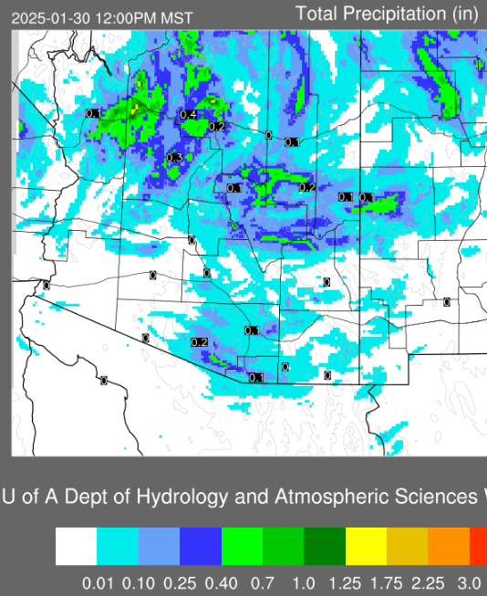
ALERT precipitation amounts for 24-hours ending at 8:00 am this morning (above and below). Amounts were light and mostly occurred over northern 2/3rds of the network. Note that some higher elevation locations had only snow. Here at house there was 0.13" of rain yesterday afternoon - first measurable rain of 2025 here.


The large, 500 mb low is centered over northeastern New Mexico this morning,  with a sharp trough axis just east of Tucson.

The 06 UTC GEFS plumes for temperature (above) show dramatic warming into middle of next week. Longer tern GFS outlook (from 06 UTC run - below) indicates dry conditions over most of the Southwest through Valentine's Day.

Monday, January 27, 2025

Light Rain To End Month


View of clear skies and Catalina Mountains from campus at 7:30 am MST this morning.


At 500 mb (above) there is a significant, closed low over southwestern California. The 06 UTC run of the GFS forecast indicates this low will be moving  across Arizona at 06 UTC on the 29th (below).


Temperatures will cool as the low comes by (GEFS plumes for temperature at airport, above) and then warm dramatically during the coming weekend. The plumes for QPF at airport (below) indicate best chances for measurable rain during Wednesday this week, as the 500 mb low moves across Arizona.


Forecast for total precipitation above (from 12 UTC run of the WRF-HRRR at Atmo) shows light amounts through noon on Thursday across most of eastern Pima County. The current forecast from the NWS Forecast Office (below) calls for 70 percent chances of measurable rain at the airport on Wednesday.

Good chances for some weather to watch as January comes to an end.

Saturday, January 25, 2025

Red Flag Warning


Some color over the Catalinas at 7:30 am MST this morning.


The NWS has issued a Red Flag Warning for today - above. The GEFS plumes for wind from 06 UTC (below) indicates several windy days this coming week.


The current NWS forecast (above) shows the Warning - current winds at the airport today indicates speeds of only 11 to 20 mph. The 500 mb analysis below and GFS forecast for 12 UTC on the 29th (second below) shows a closed low developing and digging into Arizona. Current NWS forecast indicates 60 percent POPS for the airport on next Wednesday.


Thursday, January 23, 2025

Very Dry

Six am MST view of some of the Univ. of Arizona campus lights this morning.


A strong, short wave at 500 mb is digging southeastward across Arizona today, bringing dry and windy conditions. The morning sounding from TWC/TUS (below) is one of the driest I've ever seen! Note that PW is only 0.07" and the K-Index is a mind-boggling -53.


This morning's graphic from the NWS (above) highlights temperatures through the weekend. The 06 UTC forecast from the WRF-GFS (below, from Atmo) highlights strong winds from the east again tomorrow morning.

Tuesday, January 21, 2025

Quick Look Ahead


Clear skies looking toward the Rincons at 7:15 am MST this morning.


Main focus today is on gusty winds this morning from the east - current NWS graphic re the winds above. Plot from MesoWest at the Univ. of Utah (below) shows reported gusts at 8:00 am this morning. Gusts here were around 25 mph.


Forecast wind gusts from the 06 UTC WRF-GFS (above) was valid at 8:00 am. NWS forecast for airport below highlights "breezy", but to me a forecast of possible gusts to 33 mph is for windy conditions. Long term forecast warms temperature some and brings in a 30% chance of light precipitation at the airport next Sunday night and Monday.

Thursday, January 09, 2025

Trace Of Precipitation

View looking toward the Rincons at 6:40 am MST this morning. Image at bottom shows snow up in Summerhaven at 3:00 pm yesterday. Freeze warnings in effect from the NWS for next hour and a half, and again tomorrow morning.


Many sites around the metro had a Trace or a couple of hundreths of precipitation yesterday afternoon - see MesoWest plot above for amounts through 8:00 am this morning. Here at the house we had a brief sprinkle during the early afternoon, and east winds of 30 to 40 mph during much of the day.

The 500 mb analysis this morning shows a deep trough from the Dakotas, south along the Arizona/New Mexico border, on to the end of Baja. A bit of winter has arrived.


Wednesday, January 08, 2025

Cold Wind Blowing


It is a nasty morning across Tucson area, with strong east winds bringing in some dust. View above from campus was at 9:15 am MST.  View at bottom, looking northeast from downtown, was at 9:20 am.


Current wind gusts (above) at 9:15 am from the Univ. of Utah MesoWest site. Below is forecast, from the 12 UTC run of the WRF-HRRR run at Atmo, showing forecast precipitation through 6:00 am tomorrow morning. Model indicates only some scattered, light precipitation across Pima County.


Current morning forecast (below, from the NWS) for the airport indicates slight precipitation chances today, followed by cold morning lows rest of week.


Tuesday, January 07, 2025

Brief Summary 2024

Small shower over Catalina Foothills at 4:00 pm on July 25th.

There were three months during the year with no precipitation (May, Oct, and Dec). Total rainfall for the other nine months totalled 11.78 inches. The wettest month was July with 3.72 inches.

There were 24 days with thunderstorms here at the house (as usual, I probably missed hearing thunder on a few days). Winds I estimated at 50 to 60 mph on July 18th destroyed our wooden, front gate - thus, one severe thunderstorm occurred here.

I noted no snowfall here. The coldest morning low occurred on January 9th when the temperature dropped to 21 F.

All-in-all, a pretty quiet weather year.


Unsettled Rest Of Week


Dreary view of Catalinas at 8:40 am MST this morning. Photo at bottom shows unusual ski conditions at the Capital yesterday morning.

Digging 500 mb short-wave over the Great Basin and California will impact our weather here for rest of the week.


The 06 UTC WRF-GFS forecasts dry conditions for Pima County through early Saturday morning (above); however, it predicts very windy conditions at the airport for tomorrow (below).


Current morning forecast from NWS Forecast Office (below) indicates chances for rain and snow mixed throughWednesday. So, finally a chance for some winter weather.