Friday, June 30, 2023

Beatriz

Breaking surf, Acapulco, Mexico, at 7:30 am MST this morning. Acapulco is east-southeast of Beatriz.


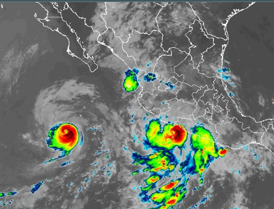
Satellite IR image (above) from 1410 UTC this morning shows Beatriz along the coast of southern Mexico, with Hurricane Adrian off to the west.

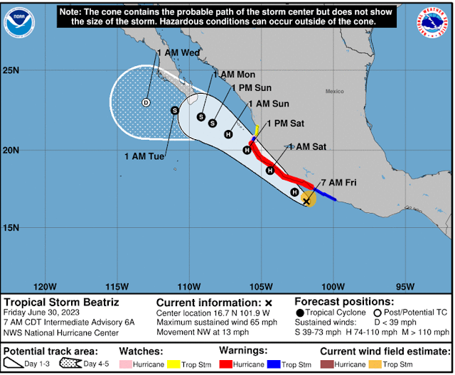
This morning's forecast for Beatriz (from NHC - below) indicaes the storm will hug the coast and then turn westward just south of Baja. If the storm turns westward, it will likely trigger a surge of low-level moisture up the GoC. This push of moisture would likely reach into southern Arizona by Monday or early Tuesday next week. There is some chance that this moisture would lead to thunderstorms and the start of our summer rainy season here in southeastern Arizona. Definitely something to watch during the long, Holiday weekend.

Monday, June 26, 2023

Hot


View at 5:50 am this morning looking toward the Rincons and some middle-level clouds.

Yesterday was very hot with a high of 111 F - not a record for the date which is 115 F.


The NWS forecast Office is highlighting the continued heat for today and tomorrow. Morning statement about the dangerous heat (above) and current forecast for airport (below). Nasty stuff - take care,

Saturday, June 24, 2023

Last Week Of June

View of Catalinas at 7:00 am MST this morning shows clear, but hazy skies.

Plumes for the 06 UTC EFS runs for temperature (above) indicate a very hot week coming for us. The NWS has issued an Excessive Heat Watch (below) because of the expected daily highs well above 100 F. Note that high temperatures at airport for past 7 days have ranged from 101 to 104 F - hot turns hotter.


In the longer term, 500 mb forecasts from the GFS 06 UTC run show a complex anticyclone pattern at 7 days (above) with centers over east Texas, California/Nevada border, and well west of Baja. By 14 days (below) the high has consolidated and is centered to our southeast, as the first week of July ends. The precipitation prospects remain low, with rainfall through 14 days extending northward just to the southeastern Arizona border (second below, also from 06 UTC GFS run). So, if model forecasts are correct, it will be well into July before our onset of summer storms and rain.


Wednesday, June 21, 2023

June 21st


Today is the summer solstice, as the sun reaches it northern-most position in our hemisphere. Today will be the longest day of 2023.

View above is of the Rincons at about 4:30 am MST this morning, while at bottom is similar view at a bit after 5:00 am on Monday. The IR image for 13 UTC (below) shows just a bit of high clouds at the edges of Arizona.


Forecast 500 mb chart from GFS (above) is valid at 00 UTC on July 1st. If the tropical storm develops as forecast it would be "Adrian." Forecast below shows GFS forecast precipitation through 00UTC on the 1st - keeps us high and dry for rest of month. Second below shows current NWS forecast for high temperatures for next week with serious heat by Monday and Tuesday.


Friday, June 16, 2023

Mid-June Looking Toward July


Nice color over the Rincons this morning at 5:30 am MST.

Looks like a windy day today - above shows 06 UTC GEFS plumes for wind and below shows 12 UTC WRF-RR forecast wind speeds valid at 2:30 pm this afternoon. The NWS Tucson office has issued a Red Flag waring for much of southeastern Arizona (second below) because of the high wildfire danger. Current forecast calls for gusts as high as 39 mph this afternoon at the airport.


Forecasts from the 06 UTC GFS for the 500 mb pattern at 7 days (above) and 14 days(below). By late June this model forecasts the 500 mb anticyclone to have shifted northward over New Mexico. The 14 day forecast for total precipitation (at bottom) continues to keep the Southwest dry; however, the situation looks interesting for early July. There's been no rain here at the house since May 18th, so a change would be most welcome.


Sunday, June 11, 2023

Quick Look Ahead


Some color over the eastern Catalinas this morning at about 5:10 am MST.


Plumes from 06 UTC GEFS (temperature above and wind below) indicate increasing heat this week with some periods of gusty winds.


Wind forecast above (from 06 UTC WRF-GFS) shows steady wind speeds above 20 mph across eastern Pima County at 1:00 pm this afternoon. Graphic below shows maximum gusts forecast by NWS Tucson for this afternoon. Current forecast for the airport indicates that gusts as high as 36 mph are possible later today.

Saturday, June 10, 2023

Spring 2023 Summary


Two views from Spring 2023 (March, April, and May) - storm clouds on May 14th (above) and red skies over the Rincons on morning of March 15th (below).

We received measurable precipitation on 4 days during March with a total of 0.75" - there was a period of light snow on the morning of the second - perhaps a quarter of an inch accumulation.

During April there was no measurable precipitation. There were record highs on the 10th (97F) and the 11th (99F), with the first 100F day occurring on April 30th.

During May there was measurable rainfall on 4 days, but the total amount only reached 0.21". Thunderstorms occurred on the 16th and 18th.

Total spring precipitation totaled 0.96", which was very near the Spring average of 1.03" here at the house since 2000. 

Tuesday, June 06, 2023

Another Windy Day


Spectacular skies  again this morning - 5:20 am MST view looking toward the Rincons. 

Weather limited to gusty, afternoon winds, as per 6 UTC plumes from GEFS for 10-m wind speeds (above).
Below is NWS graphic highlighting the expected wind gusts this afternoon.

Monday, June 05, 2023

Back From Short Trip


Contrails across the northeastern sky at 7:00 am MST this morning.

We took a short trip up to Winslow this weekend. The Rim country north of Payson was very, very green, as a result of the wet winter and spring conditions up there. Friday evening in Winslow was stormy, with lightning and thunder around 7:40 pm, but only a sprinkle of rain.

Plumes from the 06 UTC GEFS (above QPF and below winds, temperature not shown) indicate a warm and dry week ahead, with a few days having some afternoon winds.

Note the NWS reports on their website this morning that it was 36 days between high temperatures of a hundred or more F - a record long period.

Thursday, June 01, 2023

2023 Hurricane Season

 Today, June 1st, is not only the first day of meteorological Summer, it is also the start of the Hurricane Season for the  North Atlantic Basin. And, there is a disturbance in the Gulf of Mexico as the season begins - see below:

Visible image of Gulf region (below) at 1616 UTC this morning.