Thursday, October 24, 2024
Hurricane Kristy
Pre-sunrise view this morning looking toward the Rincons and cloudless skies.
Powerful Hurricane Kristy is over the Pacific, far souhwest of the southern end of Baja. Visible image (above) is from 2330 UTC yesterdy and IR image (below) is from 1400 UTC this morning. Kristy is a strong Cat. 4 hurricane and was rated just a couple of kts below Cat. 5 late yesterday.
Current NHC forecast of Kristy's track (below) keeps the storm far from land through he weekend.
Current TWC/TUS sounding (below) shows very dry and stable conditions. No rain is expected through the next couple of weeks, keeping our long dry spell going well into November.
Sunday, October 20, 2024
Re Friday
Showers and heavy clouds over west end of Catalinas at 4:00 pm MST on Friday the 18th of October.
Precipitation reports within the ALERT network for 24-hours ending at 7:00 am on Saturday (above). There were light amounts reported mainly northwest of the Catalinas. I did not see even a sprinkle here at the house.
Below is GFS forecast for total rainfall through 12 UTC on 26 October - so, continued dry through the coming week, along with warming temperatures.
Wednesday, October 16, 2024
October Continues Dry
View looking east toward the Rincons at 5:50 am MST this morning, showing clouds on and over the mountains.
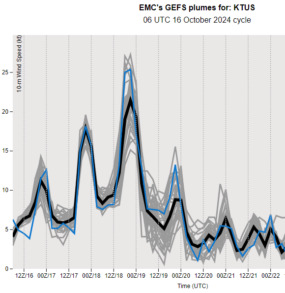
GEFS plumes for the airport from 06 UTC runs: above QPF, below Wind, and second below T. Chances for light rainfall are indicated on Friday afternoon and evening, with strong winds forecast for Friday afternoon,and distinctly cooler temperatures on the weekend.
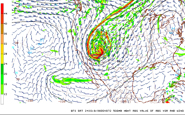
The 06 UTC runs of the WRF-GFS at Atmo show a strong, 500 mb, closed low over Arizona at 06 UTC on the 19th (above), with light precipitation across eastern and southern Pima County through noon on Sunday (below). So, it appears that we may have some weather to watch by the end of the week, after a month with no precipitation here since the 0.01" on September 17th.
Tuesday, October 08, 2024
Quick Look At Milton
An IR satellite image from yesterday (above) shows Milton northwest of Yucatan, when the storm was rated as a Cat. 5 hurricane. Current morning forecast from NHC (below) indicates Milton going ashore in the Tampa area as a major hurricane late tomorrow.
Forecasts from Tropical Tidbits (above and below) consistently show most models forecasting the storm to be at Cat 3 or 4 about the time of landfall near Tampa.
Saturday, October 05, 2024
October Starts Dry And Warm
View toward the Rincons at 6:40 am MST, just before sunrise this morning.
Plot of deteced CG flashes for 24-hours ending at 0733 UTC this morning (above from Atmo and Vaisala) shows absolutely no activity across the Southwest and northern Mexico - as quiet as it can be.
At 500 mb this morning (above, analysis from SPC) there is a large, oblong ridge that extends from northern California to the south end of Baja and beyond. There is an elongated trough to the east that extends from central Mexico north to southern Canada.
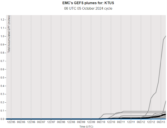
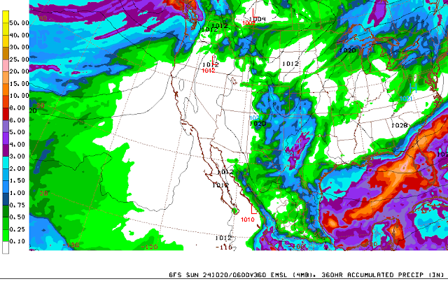
The plumes from the 06 UTC GEFS runs for QPF (above) for the airport indicate a slight chance for some activity at the end of next week. While the 06 UTC GFS run (below)indicates that precipitation avoids Arizona and much of the West through the 20th of Ocotber. So the dryness continues here, along with near-record high temperatures around 100 F. The last time we had a quarter inch or more rain here at the house was back on August 8th when there was 0.36 ".
Wednesday, October 02, 2024
September Summary
Early morning view looking toward the Rincons on September 1st 2024.
There was little weather to summarized during all of September. Light rain occured on only two days: 0.03" on the 15th and 0.01" on the 17th. The total of 0.04" was the second driest September here since 1999, after the driest total of zero during 2020. Wettest September occurred in 2014 with 2.78". I did not note any thunderstorms or strong winds during the month.
Subscribe to:
Comments (Atom)


