Monday, September 05, 2011
Moisture Way Up On Labor Day Morning
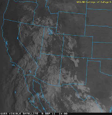
Moisture has increased significantly since yesterday evening. This has been due to both the backdoor front and much recycling due to outflows during the night. Moisture has has also streamed from the Pacific off Baja into much of the west - southern California to southern Idaho - as a weak Pacific trough at 500 mb interacts with the anticyclone over eastern Arizona/western New Mexico Visible image from 1400 UTC this morning (above) shows the widespread cloudiness over the Southwest and Great Basin. Some thunderstorms have been observed this am in southern California.
There have been quite a few showers over southeastern Arizona during the night, after a day of very isolated activity yesterday. This morning 12 of the 93 Pima County ALERT sites had rainfall and most of the rain was light and had occurred in the 3-hours before sunrise. there was a sprinkle here at house just after sunrise. There also was a large, nocturnal MCS in northern Sonora. So many factors acting to kick the PW values up to levels of 1.5" to 1.75" across southern Arizona. Radar image above shows showers over the region at 7:45 am MST this morning. Thus, a serious forecast issue today will be how long the cloud cover persists and how well the cool, near-surface air can recover.
The Atmo early WRF-GFS (by the way the early run of the WRF-GFS was very good yesterday, while the morning run was overly active) keeps the cloud cover over much of central and eastern Pima County through midday - above image is forecast OLR at noon today. However, the early run had forecast a large rain event over eastern Pima County before sunrise - so the early WRF-GFS doesn't have much credibility for the day. The morning NAM forecasts much increased activity today, but has it forecast to occur in central and western Pima County, and the Borderlands, where PWs are higher and where there'll perhaps be more sunshine.
Final graphic above is this morning's Tucson sounding - which also provides little help, since it got into a convective tower apparently. Strong super-adiabatic layer at 400 mb with dry Pacific air above still. Elevated convection was occurring at the top of yesterdays old boundary layer, while cooling and moistening from outflows and the backdoor front had occurred from the surface up to 800 mb. So, another tough forecast due to large degree to the impacts of nocturnal convection.
Subscribe to:
Post Comments (Atom)


No comments:
Post a Comment