Sunday, September 11, 2011
Big Storm Day For Tucson Area (Sept. 10, 2011)
Yesterday was a big thunderstorm day (above is radar composite at 5:17 pm MST) for the general Tucson area - a number of severe storms with both hail and wind (TUS had a gust to 66 mph and Atmo rooftop hit 78 mph). A very strong transitional pattern continued, with a westerly short-wave at 500 mb interacting with the west side of the subtropical high. Verical wind shear quite substantial and cold, middle-level temperatures. A Plains-type severe thunderstorm setting - these are most common here in Arizona during September.
---------------------------------------------------------------
Rain amounts were very heavy - 81 of 93 ALERT gauges had rain (about 85% areal coverage). But most amazing was that 31 gauges measured more than inch (as did TUS, Atmo, and here at house). Four gauges, all in Greater Tucson (i.e., low elevations), had more than two inches. Quite an event. Here at house we had 1.45" of rain along with some pea-sized hail - this is biggest rain day here since August 13th, 2008, when we had 2.32". Jim Toth reported 1.9" at his place - about 4 miles northwest of here.
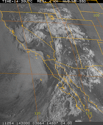
This morning the transition pattern continues. The 500 mb short-wave/cutoff is over southern California at 1200 UTC this morning. Winds are more southerly today than yesterday. The NCAR analysis above depicts a large area of high RH west of Baja (see 1430 visible satellite image below), that may be in play tomorrow. The temperatures are -10C or colder over all of the US Southwest. Looks like decent sunshine for much of day here in Tucson area.
Above is this morning's Tucson sounding. It is more stable than was yesterday morning's, with a fair amount of cooling in low-levels. Ground is very wet, so much insolation will go into evaporation today. I posted the entire SPC diagnostic to include the hodograph (upper right), which is quite an unusual one for summer here in Tucson, with veering winds and strong shear aloft. So, good chance for severe storms again - if and when/where storms are able to develop. Both the NAM and early WRF-GFS forecast much less activity for this afternoon, but both do forecast some storms by mid to late afternoon. Certainly looks like the last two days were the biggest two of the summer here in Southeast Arizona.
Subscribe to:
Post Comments (Atom)


No comments:
Post a Comment