The big news this morning is about the damaging, downslope winds that occurred yesterday afternoon across portions of Utah, Nevada, Colorado, and southern California. Many sites measured wind gusts of more than 100 mph and there was extensive damage. Jim Steenburg has much more detail posted on his blog (link to the right). The Tucson morning paper has a full-page story on yesterday's weather events - about 2/3rds of a page on the winds and about 1/3 of the page about the snows in northern Arizona.
Here in Tucson, sprinkles and light showers began about noon yesterday - image above shows a shower obscuring the Catalinas at a bit after 3pm MST on Thursday afternoon. At 5 pm yesterday we had had only a Trace here at the house and 20% of the 93 ALERT gauges had measured precipitation across eastern Pima County.
At 6 am this morning (Friday, December 2nd) there was 0.19" in the gauge here at the house. The ALERT network had 100% areal coverage of precipitation - with snow at the highest elevation sites (see web cam view near Summerhaven on Mt. Lemmon - below, at 7 am this morning). Amounts were generally about 0.15" to 0.30" at lower elevations; three middle-elevation sites had more than 0.50"; and amounts at highest elevations are uncertain due to the snowfall.
The early Atmo run of their WRF-GFS model forecasts considerably more rainfall, with amounts of 0.50" to 1 inch forecast by midnight Sunday night across most of eastern Pima County. Snowfall amounts appear considerable on both the Catalinas and Rincons. Most of the heavier precipitation is forecast to occur late Sunday and Sunday night as the next cutoff moves by.
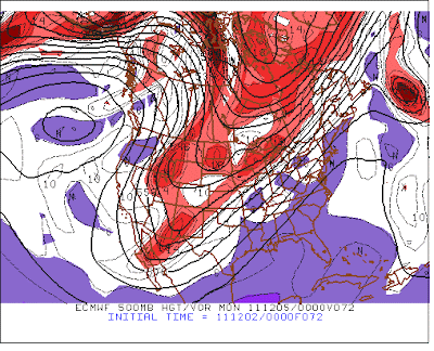
The ECMWF continues to forecast a series of strong short waves and vorticity maxima digging down the front of the 500 mb ridge over the eastern Pacific. Above is 24-hour forecast valid 5 pm today with the vorticity maxima forecast to be northwest of Salt Lake City. Below is the 72-hour forecast indicating the next short wave and vorticity maxima nearly over Salt Lake City at 5 pm MST on Sunday.
Finally, at 168-hours (next Thursday the 8th - above) the ECMWF forecasts a more powerful short wave to be digging toward the south across the Great Basin. Very active pattern persists for the western U.S, though the first week of December, and serious winter cold will cover much of the country.
Friday, December 02, 2011
Subscribe to:
Post Comments (Atom)


No comments:
Post a Comment