Friday, March 01, 2013
A Look At The Northern Pacific
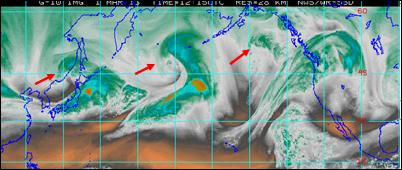
The water vapor image from 1215 UTC this morning (above) shows three distinct, upper-level vorticity maxima. The corresponding 500 mb analysis (below) shows that the western-most short wave is currently the strongest wrt vorticity. The analysis also shows a weak, subtropical low in the southern flow stream (at about 140W and 20N).
By 96-hours (below, valid at 12 UTC 5 March 2013) the GFS forecasts several things wrt the evolution of the pattern. A huge cyclone evolves and drifts westward over Siberia as ridge over Alaska intensifies. The middle short wave dives under the amplifying ridge and approaches the West Coast. The easternmost short wave plows through the western US ridge and is over the middle Mississippi Valley. So little of significance over the Southwest over the next few days, except for a nice warm-up. There is a lot of high cloudiness with the southern-stream feature (see top image) and some of this may impact the Southwest.
Subscribe to:
Post Comments (Atom)


No comments:
Post a Comment