Wednesday, April 06, 2016
Start Of Next Weather Event Only About 36 Hours Away
Various forecast models continue to be quite consistent regarding the chances for measurable rainfall at TUS during next 60-hours or so. The 21 GEFS ensemble members continue to forecast 100% POPs (below), but the range of possible amounts at the airport remains fairly large. Current NWS forecast for the airport is shown above.
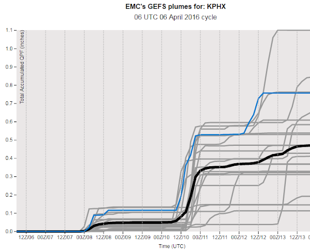
For comparison, here are the same products for PHX (Sky Harbor Airport). The GEFS QPF plumes (above) are quite different than those for TUS during next 60-hours, with range of rainfall forecast up there ranging from a Trace to just over a tenth of an inch. The ensemble members are much more aggressive for the Saturday night/Sunday follow-on event at Phoenix (they are more wishy-washy for this second event down here at Tucson). The current morning forecast for Sky Harbor from the NWS at PHX is shown below - note that these two grid forecasts are for points just over 110 miles apart.
The WRF-GFS from Atmo at 06 UTC last night forecasts a widespread, but light, event for southern Arizona through 5:00 pm MST on Friday evening - above. It is interesting that a broad plume of subtropical moisture is already apparent in the MIMIC PW products from CIMSS at University of Wisconsin - below is their 11 UTC analysis this morning. The PW values range from around 1 inch to about an inch and a half from central Baja southwestward. These amounts are as much as 50% higher than those currently forecast by the operational member of the GEFS. So it is possible that the influx of moisture into the Southwest might end up being a bit better than current model forecasts indicate - definitely something to watch. Remember also that the WRF model's track record so far this cool season has been under-forecasting QPF amounts.
Finally, contrast the broad moisture plume southwest of Baja with the beautifully defined, very narrow, atmospheric river that extends from Hawaii northward into the cyclone west of northern California.
Subscribe to:
Post Comments (Atom)


No comments:
Post a Comment