Sunday, December 18, 2022
Chance Of Sprinkles
Wednesday, December 14, 2022
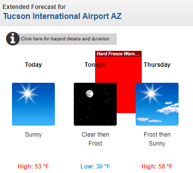
Frosty Morning
Tuesday, December 13, 2022
Widespread Rain Event
Mostly clear skies at 7:53 am MST this morning. There was a light dusting of snow on the Catalina foothills with greater amounts up at higher elevations.
The 500 mb analysis this morning (above) shows the closed low has moved eastward and is centered over southeast Wyoming - not southeast Colorado as the analysis indicates. Note the 100 kt wind speed over southwest Kansas.
Shown here are event totals for rainfall from the ALERT network. There was a second, light period of precipitation after dark last night, but bulk of precipitation was with the morning rain. Note the numerous reports of more than half an inch. Here at the house we had 0.34" in the morning, and then another 0.04" around midnight - total of 0.38" for the event.
Finally a look ahead. The GFS forecast below is valid at 18 UTC on Christmas Day and indicates a large surface high will dominate the central US, but with some rain and snow in the Northwest and the Northeast.
Monday, December 12, 2022
Rainy Morning
Chilly, windy morning across the metro with areas of moderate to heavy rain. Temperatures at low elevations in 40s and 50s F and winds gusting 30 to 40 mph. View above looking toward Catalinas from campus at 7:45 am MST, and view at bottom shows snow cover at the General Store in Summerhaven at 7:30 am.
The 500 mb analysis shows that forecasts over the weekend for this level were generally accurate - low center currently over southern Idaho, with embedded shortwaves over Arizona and central California. Radar below (1st tilt) is from 7:45 am MST, showing strong echoes across much of the metro area.
Rain amounts across the ALERT network (above and below) are for three hours ending at 8:00 am this morning. Don't have amount for here since it's raining fairly heavily and I haven't been out to the gauge. More later.
Sunday, December 11, 2022
Nasty Day Tomorrow
View of Rincons at 5:45 am MST this morning.
The 12 UTC WRF-RR this morning indicates snow inching into the southeast metro area - forecast is for accumulation through noon on Tuesday.
Morning forecasts from the NWS keep snow accumulations on the mountains (above) with high rain POPS for the airport (below). Should be very interesting day tomorrow,
Friday, December 09, 2022
Big Changes Next Week
View of the Catalinas at 7:35 am MST tis morning shows scattered clouds and some haze/dirty air over the metro area.
The GFS 500 mb forecast valid for 12 UTC this morning (above) shows a weak trough across southern California that will move across Arizona during the next 36 hours. By next Monday/Tuesday a very strong trough will dig into the West - GFS forecast below valid at 5:00 pm on next Monday.
Plumes from 00 UTC last evening (above for QPF and below for precipitation type) indicate chances for significant precipitation on Monday. Note that the forecast below for precipitation type indicates slight chances for a bit of snow mixed with the rain.Precipitation forecast above shows GFS totals through 5:00 am next Wednesday morning. Current forecast from the NWS (below) indicates very high POPs for Monday the 12th, and our second December precipitation event.
Monday, December 05, 2022
Significant Rain Event
Sunday, December 04, 2022
Rain Update
Rain amounts for 24-hours through 7:30 am in the ALERT network are shown above and below. Reports are generally in range of 0.25 to 0.60 inches. Here at house we had received 0.40" at 7:30 and moderate rain was continuing. This is first rain since October 23rd, and most significant amounts since October 6th. It is a very welcome event!
Friday, December 02, 2022
First Rain Of Winter?
Morning views at 7:00 am MST today of Catalinas top and Rincons down at bottom.
Forecast models and NWS outlooks are indicating a significant rain event for southeast Arizona tomorrow. Weekend outlook from NWS (above) indicates a half to an inch of rain possible for the metro area. The NWS forecast for the airport (below) indicates 80% POPS for tomorrow and tomorrow night. Given our long spell of dryness going back into October, this would be a much needed event.
Plumes (from the 06 UTC runs of the GEFS - above) indicate a huge increase in PW beginning tonight that peaks well over an inch tomorrow and Sunday. The plumes for rainfall at the airport (below) average around half an inch, but with some members forecasting much more.