Sunday, June 24, 2007
The Madweather Blog is currently inactive . . .
The Madweather Blog is currently inactive, as is the monsoon season in southeastern AZ. Katie and are I discussing whether to continue the Blog, or to focus this summmer on more detailed posts on the Madweather web page. I have a new post at www.madweather.com regarding the NWS Radiosonde Replacement System (RRS) program and serious data problems from sites using the new Sippican sonde. Please share this url with anyone who might be interested. Bob

Thursday, September 14, 2006
Another tropical storm of interest
I have been away on a trip to McCall, Idaho. Many wildfires burning up there with little ventilation, and skies and the air were filled with smoke on several days. Looks like things may be improving with the strong systems now affecting the northwest. I can report that all large trout in the streams around McCall easily avoided me.
I returned to find a bit of rain in the gauge, 0.04", from the unsettled weather of the last several days around Tucson.
There is another Tropical Storm, Lane, in the east Pacific and NHC forecasts it to become a hurricane and to take a track similar to John. This brings it up to the tip of Baja in about five days. However, all forecasts related to John were very poor and the GFS eventually did best with its track. The GFS is forecasting the storm northward, so we'll see how it does with this one.
I returned to find a bit of rain in the gauge, 0.04", from the unsettled weather of the last several days around Tucson.
There is another Tropical Storm, Lane, in the east Pacific and NHC forecasts it to become a hurricane and to take a track similar to John. This brings it up to the tip of Baja in about five days. However, all forecasts related to John were very poor and the GFS eventually did best with its track. The GFS is forecasting the storm northward, so we'll see how it does with this one.
Wednesday, September 06, 2006
Another dilemma re subtropics and westerlies
I have taken a quick look at some of the charts and model progs this morning.
First, the morning Tucson sounding has dried some and indicates that CAPE will likely be not very great today and that what there is should develop only over the mountains. So another quiet day is likely locally here in the Tucson metro area. The sounding (Fig. 1) shows a nice example of why the LI computed at 500 mb out here can be very deceptive!
Second, an infrared satellite image at 1230 UTC this morning (Fig. 2) shows a large area of storms and disturbed weather over and south of the southern end of the GoC. The question is what is this and will it affect our weather up here in Arizona? The only sounding available this morning near to this area is Mazatlan, which indicates a very moist and unstable air mass with low level-easterly winds. The nam and gfs models forecast a strenthening cyclone at 850 mb down in this region; however, as per usual this summer, the models have very different details in their forecasts.
I'll illustrate this with the 850 mb 42-h forecasts from the nam and gfs. The nam (Fig. 3 - left) indicates a low center SW of Baja with strong southerly winds intruding far north into northwestern Arizona, i.e., a significant surge of moisture into the lower Colorado River Basin. However, the gfs (Fig. 4 - right) predicts a cyclone over the southern GoC that is totally separated from the circulation fields further north over northern Sonora and the U.S. Southwest; i.e., no hint of a moisture surge into the U.S.
The weather in Arizona the nextcouple of days will, of course, depend upon which model's forecast is closest to what happens in the real atmosphere. Both models forecast several weak short-waves at 500 mb moving across Arziona and interacting either with increased moisture (nam with significant storms and rainfall) or residual moisture (gfs with isolated and mountain storms). I guess that I'd tend toward the gfs forecasts, given the two models' performance during Hurricane John.
First, the morning Tucson sounding has dried some and indicates that CAPE will likely be not very great today and that what there is should develop only over the mountains. So another quiet day is likely locally here in the Tucson metro area. The sounding (Fig. 1) shows a nice example of why the LI computed at 500 mb out here can be very deceptive!
Second, an infrared satellite image at 1230 UTC this morning (Fig. 2) shows a large area of storms and disturbed weather over and south of the southern end of the GoC. The question is what is this and will it affect our weather up here in Arizona? The only sounding available this morning near to this area is Mazatlan, which indicates a very moist and unstable air mass with low level-easterly winds. The nam and gfs models forecast a strenthening cyclone at 850 mb down in this region; however, as per usual this summer, the models have very different details in their forecasts.
I'll illustrate this with the 850 mb 42-h forecasts from the nam and gfs. The nam (Fig. 3 - left) indicates a low center SW of Baja with strong southerly winds intruding far north into northwestern Arizona, i.e., a significant surge of moisture into the lower Colorado River Basin. However, the gfs (Fig. 4 - right) predicts a cyclone over the southern GoC that is totally separated from the circulation fields further north over northern Sonora and the U.S. Southwest; i.e., no hint of a moisture surge into the U.S.
The weather in Arizona the nextcouple of days will, of course, depend upon which model's forecast is closest to what happens in the real atmosphere. Both models forecast several weak short-waves at 500 mb moving across Arziona and interacting either with increased moisture (nam with significant storms and rainfall) or residual moisture (gfs with isolated and mountain storms). I guess that I'd tend toward the gfs forecasts, given the two models' performance during Hurricane John.
Sunday, September 03, 2006
Status of Hurricane John and the back-door front
Pat Holbrook said at 2:12 pm on Thursday August 31st
Looking at satellite trends and station data, the lowest pressures are on the east side of the gulf of california...still think this one will be heading along the same direction as it is now and enter into the southern gulf and possibly up to Los Mochis area before landfall.
Pat called this one very well! Current visible loops seem to indicate that what's left of Hurricane John is making landfall now south of Guaymas. Obviously the GFDL model was far superior to the other models, and the consensus track has been consistently wrong. It is still possible that an orphan low-level circulation will jump Baja and drift out into the Pacific. But it appears that the main moisture and mid-level vorticity from John is heading across far southeast Arizona and into New Mexico.
CORRECTION TO ABOVE at 3:30 pm Labor Day - the circulation that appeared to go ashore in imagery yesterday wasn't the remnants of John. Imagery today indictes that John continues to be nearly stationary over the northern Gulf of California.
Looking at satellite trends and station data, the lowest pressures are on the east side of the gulf of california...still think this one will be heading along the same direction as it is now and enter into the southern gulf and possibly up to Los Mochis area before landfall.
Pat called this one very well! Current visible loops seem to indicate that what's left of Hurricane John is making landfall now south of Guaymas. Obviously the GFDL model was far superior to the other models, and the consensus track has been consistently wrong. It is still possible that an orphan low-level circulation will jump Baja and drift out into the Pacific. But it appears that the main moisture and mid-level vorticity from John is heading across far southeast Arizona and into New Mexico.
CORRECTION TO ABOVE at 3:30 pm Labor Day - the circulation that appeared to go ashore in imagery yesterday wasn't the remnants of John. Imagery today indictes that John continues to be nearly stationary over the northern Gulf of California.
I've emphasized for several blog posts that when a TS comes directly into the Gulf the situation is much more complex than when a TS moves northwestward across the region southwest of Baja tip. This has certainly proved to be the case with John.
As for the backdoor front, the GFS model did very well (beginning last Tuesday or so) in forecasting this feature to broach the divide and come into southern Arizona. We were in the southeastern Arizona grasslands near Sonoita Friday afternoon and Saturday. By sunrise on Saturday (yesterday) the front had passed and we experienced a cool, suppressed day down there with brisk east winds. A careful look at the surface observations (and 24-h changes - an essential aspect of surface analysis in the Southwest during summer!) indicates that the front passed Tucson around 5 to 6 am yesterday morning; Casa Grande around 10 to 11 am; and Skyharbor in Phoenix between noon and 1 pm. High temperaturs yesterday east of Phoenix to Sells line were 5 to 10 F cooler than on Friday. The front appeared to stall from around Sells northward to west of Phoenix, providing a nice convergence zone that helped the development of the large MCS that occurred over south-central Arizona late yesterday afternoon and evening. This system produced a huge outflow of cool air that pushed southwest past Yuma and which came uphill across Tucson around 10:30 pm, with a shift to north-northwest winds and a jump in the dewpoint temperatures.
Storms today and tomorrow will occur where there's enough low-level heat, combined with moisture from John, to produce CAPE - mid-level temps are cooler over the north and west parts of the state, but deeper moisture is present over the south-central and southeast regions. Depending on exactly how remnants of John wander around, the models (which still have vastly different forecast scenarios) indicate that a dry-out may occur by Tuesday. Interestingly, the NAM spins another tropical system up southwest of Baja by 84 hours.
Friday, September 01, 2006
Summer rainfall
I have been keeping daily rainfall records here at the house starting July 1, 1999. Since the summer season (June, July, and August) has ended, I thought I'd provide a summary for 2006 and compare to recent years.
My rain gauge is at approximately 32.27 N and 110.93 W, with elevation of 2369 ft MSL.
Rainfall here in 2006 was: June = 0.50" July = 4.88" August = 1.09" Total = 6.47"
There was measurable rainfall on 27 of 92 days (that infamous 30% POP we see so often in the summer forecasts).
Heavy storms on just 4 days accounted for 65% of the summer total. Summer rainfall, rank- ordered, for last eight years at the house:
1999 - 9.41" (no records for June)
2006 - 6.47"
2000 - 6.30"
2005 - 5.43"
2003 - 4.69"
2002 - 4.15"
2001 - 2.70"
2004 - 2.44"
So, a nice wet summer here - not at all close to wettest, but much better than driest year.
My rain gauge is at approximately 32.27 N and 110.93 W, with elevation of 2369 ft MSL.
Rainfall here in 2006 was: June = 0.50" July = 4.88" August = 1.09" Total = 6.47"
There was measurable rainfall on 27 of 92 days (that infamous 30% POP we see so often in the summer forecasts).
Heavy storms on just 4 days accounted for 65% of the summer total. Summer rainfall, rank- ordered, for last eight years at the house:
1999 - 9.41" (no records for June)
2006 - 6.47"
2000 - 6.30"
2005 - 5.43"
2003 - 4.69"
2002 - 4.15"
2001 - 2.70"
2004 - 2.44"
So, a nice wet summer here - not at all close to wettest, but much better than driest year.
How complex can things get?
I have been tied up with other work this morning and have just now gotten around to looking at this morning's weather charts and model progs out through 48 hours.
This is one of the most complex and difficult situations that I can remember seeing here in the Southwest.
I have taken a very careful look at the NAM and GFS models out through 48-h; I have little confidence in any of the models or their forecasts beyond 48-h. There are strong and competing features in battle with each other during the next 48-h, as Hurricane John moves north at the same time as a very large upper-air blocking pattern sets up over the north-central U.S. While these things happen, a strong Canadian cold front moves rapidly southward down the front range of the Rockies, bringing much rain and moisture in its wake. This front back-doors into the Southwest and brings low-level winds around to the east over the eastern half of Arizona. Finally, low-level moisture surges very rapidly northward after after 24 to 30 hours. The only NWS offices discussing in their FDs the role of the cold front in determining the Holiday weekend weather are ELP and ABQ, but it seems fairly clear that the front is going to affect the evolution of events over a large part of Arizona also.
Brief summary of the models progs at 12, 30, and 48 hours follows:
12 - hours: Both models indicate light northerly winds at 850 and 700 mb. At 500 mb both models have light westerly flow over southern Arizona, with a weak anticylone south of the border. Upper-level winds are westerly, are strong and appear confluent over southern Arizona.
30 - hours: Winds at 850 mb and 700 mb continue northerly over much of southern Arizona. The cold front has pushed into southern New Mexico and is further west in NAM with stronger easterly winds. The NAM has northerly winds south to about Hermosilla; whereas, the GFS indicates the expected Gulf Surge has moved into the lower Colorado River Basin. Both models indicate moisture advection at 700 mb into southeastern Arizona from the east. At 700 to 500 mb there is a pronounced inverted trough swinging around Hurrican John and approaching the New Mexico bootheel. Increasing heights at 700 mb over west Texas act to increase the gradient and southeasterly winds to the northeast of John over much of northwestern Mexico. Upper-level winds continue strong from west but may be slightly difluent over southern Arizona. The NAM is moving John up the east side of Baja and the GFS is moving John up along the west coast of Baja.
48 - hours: At this time the two models have diverged markedly in their forecasts. The NAM has begun moving John westward, probably because of the large block to north and northeast. Moisture has surged rapidly northward as far as southern Nevada. The backdoor front has produced strong easterly winds over southeastern Arizona, but signficant moist advection continues at 700 mb from the cool side of the front. There is a weak 500 mb trough and vort max over southeastern Arizona, but 500 mb winds are strong northerly over most of the state. Upper-level flow appears divergent.
In contrast, the GFS continues moving John northward; the surge has moved far north and into the southern Great Basin. Easterly winds have increased over southeastern Arizona in lower-levels. GFS also has weak trough and vort max at 500 mb over southeastern Arizona. Upper-level flow is weaker and difluent over southeast Arizona.
So what does all this mean? It appears that through 48 hours the most signficant storms will occur Saturday afternoon and night.
Southern New Mexico appears to have most certain chance of widespread significant storms and rains. Southeastern Arizona may have a good storm event, but timing of moisture increases from John and encroachment of front from the east will be critical. If the front comes through too soon, the best activity zone will be shifted to the west and northwest. There is a good liklihood that the influx of low-level moisture will push far enough north that northwestern Arizona and southern Nevada (and nearby California) will experience signficant storms also.
As I said at the start of this ramble, things are really complex and getting the forecast right for tomorrow afternoon and night is a huge challenge! In the longer-term, the GFS continues John northward into the lower Colorado basin, carving out a weak trough to the west of the block. The magnitude of the rain event that the GFS forecasts after 48 hours is HUGE in the lower Colorado River Basin. The NAM takes John to the west and just forecasts a nice pattern for strong storms over the Southwest for several days.
This is one of the most complex and difficult situations that I can remember seeing here in the Southwest.
I have taken a very careful look at the NAM and GFS models out through 48-h; I have little confidence in any of the models or their forecasts beyond 48-h. There are strong and competing features in battle with each other during the next 48-h, as Hurricane John moves north at the same time as a very large upper-air blocking pattern sets up over the north-central U.S. While these things happen, a strong Canadian cold front moves rapidly southward down the front range of the Rockies, bringing much rain and moisture in its wake. This front back-doors into the Southwest and brings low-level winds around to the east over the eastern half of Arizona. Finally, low-level moisture surges very rapidly northward after after 24 to 30 hours. The only NWS offices discussing in their FDs the role of the cold front in determining the Holiday weekend weather are ELP and ABQ, but it seems fairly clear that the front is going to affect the evolution of events over a large part of Arizona also.
Brief summary of the models progs at 12, 30, and 48 hours follows:
12 - hours: Both models indicate light northerly winds at 850 and 700 mb. At 500 mb both models have light westerly flow over southern Arizona, with a weak anticylone south of the border. Upper-level winds are westerly, are strong and appear confluent over southern Arizona.
30 - hours: Winds at 850 mb and 700 mb continue northerly over much of southern Arizona. The cold front has pushed into southern New Mexico and is further west in NAM with stronger easterly winds. The NAM has northerly winds south to about Hermosilla; whereas, the GFS indicates the expected Gulf Surge has moved into the lower Colorado River Basin. Both models indicate moisture advection at 700 mb into southeastern Arizona from the east. At 700 to 500 mb there is a pronounced inverted trough swinging around Hurrican John and approaching the New Mexico bootheel. Increasing heights at 700 mb over west Texas act to increase the gradient and southeasterly winds to the northeast of John over much of northwestern Mexico. Upper-level winds continue strong from west but may be slightly difluent over southern Arizona. The NAM is moving John up the east side of Baja and the GFS is moving John up along the west coast of Baja.
48 - hours: At this time the two models have diverged markedly in their forecasts. The NAM has begun moving John westward, probably because of the large block to north and northeast. Moisture has surged rapidly northward as far as southern Nevada. The backdoor front has produced strong easterly winds over southeastern Arizona, but signficant moist advection continues at 700 mb from the cool side of the front. There is a weak 500 mb trough and vort max over southeastern Arizona, but 500 mb winds are strong northerly over most of the state. Upper-level flow appears divergent.
In contrast, the GFS continues moving John northward; the surge has moved far north and into the southern Great Basin. Easterly winds have increased over southeastern Arizona in lower-levels. GFS also has weak trough and vort max at 500 mb over southeastern Arizona. Upper-level flow is weaker and difluent over southeast Arizona.
So what does all this mean? It appears that through 48 hours the most signficant storms will occur Saturday afternoon and night.
Southern New Mexico appears to have most certain chance of widespread significant storms and rains. Southeastern Arizona may have a good storm event, but timing of moisture increases from John and encroachment of front from the east will be critical. If the front comes through too soon, the best activity zone will be shifted to the west and northwest. There is a good liklihood that the influx of low-level moisture will push far enough north that northwestern Arizona and southern Nevada (and nearby California) will experience signficant storms also.
As I said at the start of this ramble, things are really complex and getting the forecast right for tomorrow afternoon and night is a huge challenge! In the longer-term, the GFS continues John northward into the lower Colorado basin, carving out a weak trough to the west of the block. The magnitude of the rain event that the GFS forecasts after 48 hours is HUGE in the lower Colorado River Basin. The NAM takes John to the west and just forecasts a nice pattern for strong storms over the Southwest for several days.
Thursday, August 31, 2006
Hurricane John and Arizona weather
Today in southern Arizona is much like yesterday wrt CAPE. However, the steering winds today are light westerly and there is little directional shear above 500 mb. Thus, another day favoring heavy storms over the mountains and lots of anvil cloud over many low elevation areas.
Hurricane John is moving toward southern tip of Baja as a strong Cat 3, or even a Cat 4, hurricane. Yesterday's discussion remains essentially valid. Initially, the pressure gradient at low-levels becomes cross or down the Gulf of California. The NAM actually predicts light northerly winds at 850 mb over southern Arizona tomorrow afternoon, but as John moves westward away from the tip of Baja, a rapid push of moisture up the GoC should occur, probably coming into the U.S. late Friday night. A turn toward the west sooner than NHC predicts would bring moisture northward more quickly.
On Saturday the moisture influx from John should interact with a strong back-door cold front coming westward across the Continental Divide, producing perhaps the most intense storms of the weekend.
There are too many complexities in the situation to have much forecast confidence beyond Saturday and even the details of Saturday are difficult to anticipate, since the flow may become strongly downslope in the local Tucson area.
A final possible complication to at least consider is that the GFDL model continues to predict that Hurricane John will move directly into the GoC and make landfall on the western coast of Mexico.
Hurricane John is moving toward southern tip of Baja as a strong Cat 3, or even a Cat 4, hurricane. Yesterday's discussion remains essentially valid. Initially, the pressure gradient at low-levels becomes cross or down the Gulf of California. The NAM actually predicts light northerly winds at 850 mb over southern Arizona tomorrow afternoon, but as John moves westward away from the tip of Baja, a rapid push of moisture up the GoC should occur, probably coming into the U.S. late Friday night. A turn toward the west sooner than NHC predicts would bring moisture northward more quickly.
On Saturday the moisture influx from John should interact with a strong back-door cold front coming westward across the Continental Divide, producing perhaps the most intense storms of the weekend.
There are too many complexities in the situation to have much forecast confidence beyond Saturday and even the details of Saturday are difficult to anticipate, since the flow may become strongly downslope in the local Tucson area.
A final possible complication to at least consider is that the GFDL model continues to predict that Hurricane John will move directly into the GoC and make landfall on the western coast of Mexico.
Wednesday, August 30, 2006
Tropical cyclones galore
First - yesterday had some thunderstorm activity in southeastern Arizona, especially along the Borderlands south and southwest of Tucson. Observed lots of thunder and lightning here at house but rain stayed on the north side of Rillito wash - as per usual.
Today's morning sounding indicates about 33 mm of precipitable water and some decent CAPE, especially over mountains. There are light and variable winds to above 400 mb, so this will likely be a day when storms form on mountains and then wander around wherever their outflows take them.
On the large-scale, the pattern has been changing significantly. At 500 mb the subtropical anticyclone has shifted far southeastward over northeastern Mexico. While from 300 to 200 mb it is not clear that there even is an over-land anticyclone, except over far south Mexico. Down at 700 mb there is an anticyclone over northeastern Mexico and a weak trough extends from southwest Texas westward to northen Baja. Very moist air lies in and south of this trough, with precipitable water values greater than 50 mm.
The big weather uncertainties are what will happen from now through Labor Day. Hurricane John (click for IR image) was found to be a Cat 3 storm by NOAA aircraft early this morning. Complicating the picture is the fact that nearby TS Kristy appears to be approaching hurricane intensity also. The two storms are quite close and it is not obvious to me how they will interact. There was a large ensemble spread yesterday, with the GFDL model actually predicting John would move up the Gulf of California.
The moisture surge situation becomes complicated if a strong hurricane moves into the mouth of Gulf or near the tip of Baja. Initially, the pressure gradient becomes north-to-south with low-level winds blowing across or down the Gulf. If the storm then moves westward, its winds and associated pressure rises can trigger the northward surge of moisture, or the storm can continue northward bringing its moisture field with it into the Southwest.
The current NHC forecasts indicate John to be moving from south of the mouth of the Gulf to near the tip of Baja as a strong Cat 3 hurricane on Friday. Thus, the situation is extremely complex and the timing of a strong push of tropical air into the Southwest is very uncertain. All of this complicated by the fact a strong cold front moves rapidly down the High Plains on Saturday and Sunday, trying to back-door into southern Arizona.
All that one can do with such a difficult mix of mid-latitude and tropical features is to watch the observations very very closely. Of course, most weather attention the next few days will be on the east coast events associated with Ernesto.
Today's morning sounding indicates about 33 mm of precipitable water and some decent CAPE, especially over mountains. There are light and variable winds to above 400 mb, so this will likely be a day when storms form on mountains and then wander around wherever their outflows take them.
On the large-scale, the pattern has been changing significantly. At 500 mb the subtropical anticyclone has shifted far southeastward over northeastern Mexico. While from 300 to 200 mb it is not clear that there even is an over-land anticyclone, except over far south Mexico. Down at 700 mb there is an anticyclone over northeastern Mexico and a weak trough extends from southwest Texas westward to northen Baja. Very moist air lies in and south of this trough, with precipitable water values greater than 50 mm.
The big weather uncertainties are what will happen from now through Labor Day. Hurricane John (click for IR image) was found to be a Cat 3 storm by NOAA aircraft early this morning. Complicating the picture is the fact that nearby TS Kristy appears to be approaching hurricane intensity also. The two storms are quite close and it is not obvious to me how they will interact. There was a large ensemble spread yesterday, with the GFDL model actually predicting John would move up the Gulf of California.
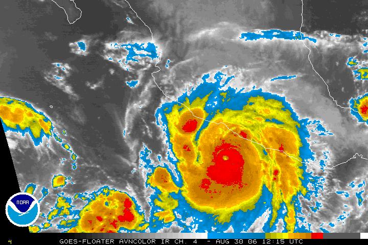
The moisture surge situation becomes complicated if a strong hurricane moves into the mouth of Gulf or near the tip of Baja. Initially, the pressure gradient becomes north-to-south with low-level winds blowing across or down the Gulf. If the storm then moves westward, its winds and associated pressure rises can trigger the northward surge of moisture, or the storm can continue northward bringing its moisture field with it into the Southwest.
The current NHC forecasts indicate John to be moving from south of the mouth of the Gulf to near the tip of Baja as a strong Cat 3 hurricane on Friday. Thus, the situation is extremely complex and the timing of a strong push of tropical air into the Southwest is very uncertain. All of this complicated by the fact a strong cold front moves rapidly down the High Plains on Saturday and Sunday, trying to back-door into southern Arizona.
All that one can do with such a difficult mix of mid-latitude and tropical features is to watch the observations very very closely. Of course, most weather attention the next few days will be on the east coast events associated with Ernesto.
Tuesday, August 29, 2006
Significant moisture surge into southern Arizona
The moisture surge discussed yesterday has occurred and been quite spectacular across southern Arizona.
First, there has been a classic and very pronounced surge of low-level moisture northward up the Gulf of California. Pressures at Yuma dropped quite low yesterday afternoon and the moisture surge was observed near dark between 8 and 9 pm there. The passage of the surge was quite spectacular as indicated by the changes in surface conditions from 8 to 9 pm. It has continued through the night. The NWS Doppler radar data show that the surge extends upward to just above 3000 ft MSL at Yuma this morning.
However, across southeast and south central Arizona moisture has also increased dramatically over the night due to both outflows from northern Mexico and the moist flow behind the back-door front, also mentioned yesterday. The change in the soundings at TUS from yesterday to this morning is also quite spectacular. Strong moisture increases are apparent up to 600 mb. This influx of moisture occurred during the late night and early morning hours and was more gradual than the surge observed at Yuma. Surface observations from Douglas to Tucson to Sasabe to Sells all showed significant dewpoint increases during hte night.
The morning sounding at Tucson indicates that signifcant CAPE may be present by afternoon. If the low-level moisture continues to increase, potential CAPE by afternoon could become quite large for out here. Temperatures at 500 mb have fallen and there is some steering flow from the north-northeast. Thus, it appears that an interesting and stormy afternoon is possible over southeastern Arizona.
In the longer term, Tropical Storm John developed yesterday afternoon. The NHC expects it to reach hurricane strength this morning. The forecast by NHC anticipates that John will rapidly intensify into a major hurricane and track to the northwest along a track that would, if it verifies, bring another major push of moisture into the Southwest by Friday and Saturday. All told a very interesting week and Labor Day weekend shaping up!
First, there has been a classic and very pronounced surge of low-level moisture northward up the Gulf of California. Pressures at Yuma dropped quite low yesterday afternoon and the moisture surge was observed near dark between 8 and 9 pm there. The passage of the surge was quite spectacular as indicated by the changes in surface conditions from 8 to 9 pm. It has continued through the night. The NWS Doppler radar data show that the surge extends upward to just above 3000 ft MSL at Yuma this morning.
However, across southeast and south central Arizona moisture has also increased dramatically over the night due to both outflows from northern Mexico and the moist flow behind the back-door front, also mentioned yesterday. The change in the soundings at TUS from yesterday to this morning is also quite spectacular. Strong moisture increases are apparent up to 600 mb. This influx of moisture occurred during the late night and early morning hours and was more gradual than the surge observed at Yuma. Surface observations from Douglas to Tucson to Sasabe to Sells all showed significant dewpoint increases during hte night.
The morning sounding at Tucson indicates that signifcant CAPE may be present by afternoon. If the low-level moisture continues to increase, potential CAPE by afternoon could become quite large for out here. Temperatures at 500 mb have fallen and there is some steering flow from the north-northeast. Thus, it appears that an interesting and stormy afternoon is possible over southeastern Arizona.
In the longer term, Tropical Storm John developed yesterday afternoon. The NHC expects it to reach hurricane strength this morning. The forecast by NHC anticipates that John will rapidly intensify into a major hurricane and track to the northwest along a track that would, if it verifies, bring another major push of moisture into the Southwest by Friday and Saturday. All told a very interesting week and Labor Day weekend shaping up!
Monday, August 28, 2006
Another difficult forecast day
A look at the observations this morning, as well as the NAM and GFS, indicates another difficult forecast situation for the Borderlands. The following is my brief discussion of the situation.
First, the middle and upper-level wave spinning over the northern Plains has a weak trough hanging back, east-to-west, over the western U.S. The models appear to move this feature southward across at least eastern Arizona tomorrow. There is currently cold advection with the S/W, and this would be quite favorable, especially given the very nice vertical wind shear profiles that develop during next 24-hours, for strong storms, if there low-level moisture and CAPE in place. There also appears to be an upper-level moisture plume from what was Ileana approaching the Southwest.
A gradual advection of low-level moisture is occurring across southern New Mexico and into southeastern Arizona - this is due to the back-door cold front that has coming down the Plains as it tries to push westward across the Continental Divide.
Now to the south. No observational data wrt to upper-air soundings, as per the last 7 weeks. The NAM initializes a strong inverted trough over the southern Gulf of California at 500 and 700 mb - the 700 mb trough appears to brush across southern Arizona tomorrow afternoon. This occurs about the same time the 500-300 mb weak S/W is positioned over eastern Arizona. Thus, the question is: how much of this is real and how much is happening only in the NAM world?
Satellite loops indicate that a pronounced wave is moving westward across the lower Gulf of California. So, the moisture surge predicted by the NAM may indeed be getting underway. Surface obs indicate very high dewpoints along the GoC and south winds at LaPaz and Loretto. The U 0f A GPS precipitable water time series page shows that a huge increase in precipitable water has occurred at Hermosilla during past nine hours, i.e., since midnight. Values there are almost 50 mm this morning.
So it appears that there is probably at least a 50/50 chance of everything coming together over next 24 to 36 hours to support a new round of summer thunderstorms over parts of southern Arizona. The dilemma here is that very dry air will be lurking very near. The key is likely to be tied to whether or not a GoC surge actually occurs by tomorrow morning.
Who said that summer forecasting is easy?
First, the middle and upper-level wave spinning over the northern Plains has a weak trough hanging back, east-to-west, over the western U.S. The models appear to move this feature southward across at least eastern Arizona tomorrow. There is currently cold advection with the S/W, and this would be quite favorable, especially given the very nice vertical wind shear profiles that develop during next 24-hours, for strong storms, if there low-level moisture and CAPE in place. There also appears to be an upper-level moisture plume from what was Ileana approaching the Southwest.
A gradual advection of low-level moisture is occurring across southern New Mexico and into southeastern Arizona - this is due to the back-door cold front that has coming down the Plains as it tries to push westward across the Continental Divide.
Now to the south. No observational data wrt to upper-air soundings, as per the last 7 weeks. The NAM initializes a strong inverted trough over the southern Gulf of California at 500 and 700 mb - the 700 mb trough appears to brush across southern Arizona tomorrow afternoon. This occurs about the same time the 500-300 mb weak S/W is positioned over eastern Arizona. Thus, the question is: how much of this is real and how much is happening only in the NAM world?
Satellite loops indicate that a pronounced wave is moving westward across the lower Gulf of California. So, the moisture surge predicted by the NAM may indeed be getting underway. Surface obs indicate very high dewpoints along the GoC and south winds at LaPaz and Loretto. The U 0f A GPS precipitable water time series page shows that a huge increase in precipitable water has occurred at Hermosilla during past nine hours, i.e., since midnight. Values there are almost 50 mm this morning.
So it appears that there is probably at least a 50/50 chance of everything coming together over next 24 to 36 hours to support a new round of summer thunderstorms over parts of southern Arizona. The dilemma here is that very dry air will be lurking very near. The key is likely to be tied to whether or not a GoC surge actually occurs by tomorrow morning.
Who said that summer forecasting is easy?
Sunday, August 27, 2006
Forecasting for the tropics today
Just a general remark this morning.
I'm certainly glad that I wasn't working the midshift at NHC this morning!
The models (at least the NAM and GFS) are at best ambigous in their solutions regarding what might evolve at low latitudes the next few days. Ernesto seems to go a variety of different directions and the NAM tries to bring another tropical system up toward Baja at end of period - last time it did this it was an artifact and nothing materialized.
The NHC does anticipate that the tropical wave coming off Central America will develop into a tropical system. Meanwhile, there is something sitting over the southern Gulf of California with considerable associated convection. It seems to be a weak, nearly stationary low, BUT with the absence of observational data over much of Mexico continuing, the models seem constrained mostly by their last forecast.
What a mess! Does anyone care that the missing sounding data have caused extremely unreliable model forecasts for much of southwestern N.A. this summer?
I'm certainly glad that I wasn't working the midshift at NHC this morning!
The models (at least the NAM and GFS) are at best ambigous in their solutions regarding what might evolve at low latitudes the next few days. Ernesto seems to go a variety of different directions and the NAM tries to bring another tropical system up toward Baja at end of period - last time it did this it was an artifact and nothing materialized.
The NHC does anticipate that the tropical wave coming off Central America will develop into a tropical system. Meanwhile, there is something sitting over the southern Gulf of California with considerable associated convection. It seems to be a weak, nearly stationary low, BUT with the absence of observational data over much of Mexico continuing, the models seem constrained mostly by their last forecast.
What a mess! Does anyone care that the missing sounding data have caused extremely unreliable model forecasts for much of southwestern N.A. this summer?
Saturday, August 26, 2006
Drying out slowly
The TUS sounding this morning shows west-northwest winds in the 600 to 400 mb layer and precipitable water values down to 33.5 mm. The PHX sounding is drier with stronger winds.
Interestingly, the TUS sounding still has a fair amount of potential CAPE, so storms continue likely over mountains to the east.
I have just checked the 12Z soundings for TUS for the last four mornings. The winds in the 600 to 400 mb layer have been west-southwest to west-northwest each of these days and precipitable water has ranged from 42.9 to this morning's 33.5 mm. One could ask:
Did the monsoon end four days ago?
What kind of storms have been occurring with baroclinic westerly winds and lingering high moisture and CAPE?
I would call these "hybrid" or "mixed flow regime" storms since they are occurring in a meteorologically mixed environment. There is a preprint article about hybrid storms at:
http://www.wrh.noaa.gov/twc/monsoon/bobpres.php
Interestingly, the TUS sounding still has a fair amount of potential CAPE, so storms continue likely over mountains to the east.
I have just checked the 12Z soundings for TUS for the last four mornings. The winds in the 600 to 400 mb layer have been west-southwest to west-northwest each of these days and precipitable water has ranged from 42.9 to this morning's 33.5 mm. One could ask:
Did the monsoon end four days ago?
What kind of storms have been occurring with baroclinic westerly winds and lingering high moisture and CAPE?
I would call these "hybrid" or "mixed flow regime" storms since they are occurring in a meteorologically mixed environment. There is a preprint article about hybrid storms at:
http://www.wrh.noaa.gov/twc/monsoon/bobpres.php
Drying out slowly
The TUS sounding this morning shows west-northwest winds in the 600 to 400 mb layer and precipitable water values down to 33.5 mm. The PHX sounding is drier with stronger winds.
Interestingly, the TUS sounding still has a fair amount of potential CAPE, so storms continue likely over mountains to the east.
I have just checked the 12Z soundings for TUS for the last four mornings. The winds in the 600 to 400 mb layer have been west-southwest to west-northwest each of these days and precipitable water has ranged from 42.9 to this morning's 33.5 mm. One could ask:
Did the monsoon end four days ago?
What kind of storms have been occurring with baroclinic westerly winds and lingering high moisture and CAPE?
I would call these "hybrid" or "mixed flow regime" storms since they are occurring in a meteorologically mixed environment. There is a preprint article about hybrid storms at:
http://www.wrh.noaa.gov/twc/monsoon/bobpres.php
Interestingly, the TUS sounding still has a fair amount of potential CAPE, so storms continue likely over mountains to the east.
I have just checked the 12Z soundings for TUS for the last four mornings. The winds in the 600 to 400 mb layer have been west-southwest to west-northwest each of these days and precipitable water has ranged from 42.9 to this morning's 33.5 mm. One could ask:
Did the monsoon end four days ago?
What kind of storms have been occurring with baroclinic westerly winds and lingering high moisture and CAPE?
I would call these "hybrid" or "mixed flow regime" storms since they are occurring in a meteorologically mixed environment. There is a preprint article about hybrid storms at:
http://www.wrh.noaa.gov/twc/monsoon/bobpres.php
Friday, August 25, 2006
Difficult forecasts down in the Borderlands
Copy of e-mail sent earlier today to local weather watchers.
----------------------------------------------------------------------
Mike and all,
Well I sure goofed yesterday by not paying attention to the outflow/mesohigh spreading southeast over us. That's of course a real kiss of death. What happens when you're trying to do too many things at once.
Today seems really a mess - westerlies with drying in top half of troposphere - how far will it mix down? No matter how I fiddle with TUS sounding in low levels, I get afternoon max theta-w of 22C and thus only a tiny sliver of CAPE.
PHX sounding looks like it should be thundering there right now - maybe a bad sounding point? Definitely some CAPE up there but stronger west winds lower down bode ill. Guess that we can say mountains should be active yet again - so what's new?
The upper-air charts show cold advection west of trof in NW U.S. at 500 and 300 mb indicating southward movement as per models' forecasts. I guess that I am not sure what a fairly strong wave like this coming south over continent in summer might actually evolve to. The first waves that have come by here have come off Pacific. A piece of the northern S/W may end up abandoned by its mother wave and wander around in the subtropical ridge after tomorrow.
NAM shows two tropical and one baroclinic 500 mb vort centers at play through the weekend - we know two are real but third?????? The GFS hints at the end of the monsoon in about 7 days - although it may be happening next couple of days. Then the GFS let's it come back in at longer periods. But the GFS doesn't seem to know about TD 5, potential hurricane Ernesto. Of course, neither of these models seems to have had much reliability for weeks.
I'm plenty confused and so, I'll just sit and watch what happens!
Bob
----------------------------------------------------------------------
Mike and all,
Well I sure goofed yesterday by not paying attention to the outflow/mesohigh spreading southeast over us. That's of course a real kiss of death. What happens when you're trying to do too many things at once.
Today seems really a mess - westerlies with drying in top half of troposphere - how far will it mix down? No matter how I fiddle with TUS sounding in low levels, I get afternoon max theta-w of 22C and thus only a tiny sliver of CAPE.
PHX sounding looks like it should be thundering there right now - maybe a bad sounding point? Definitely some CAPE up there but stronger west winds lower down bode ill. Guess that we can say mountains should be active yet again - so what's new?
The upper-air charts show cold advection west of trof in NW U.S. at 500 and 300 mb indicating southward movement as per models' forecasts. I guess that I am not sure what a fairly strong wave like this coming south over continent in summer might actually evolve to. The first waves that have come by here have come off Pacific. A piece of the northern S/W may end up abandoned by its mother wave and wander around in the subtropical ridge after tomorrow.
NAM shows two tropical and one baroclinic 500 mb vort centers at play through the weekend - we know two are real but third?????? The GFS hints at the end of the monsoon in about 7 days - although it may be happening next couple of days. Then the GFS let's it come back in at longer periods. But the GFS doesn't seem to know about TD 5, potential hurricane Ernesto. Of course, neither of these models seems to have had much reliability for weeks.
I'm plenty confused and so, I'll just sit and watch what happens!
Bob
Thursday, August 24, 2006
Satellite Precipitable Water Vapor
The determination of the impacts of hurricane Ileana have proved difficult to quantify, given the moist precursor conditions, as discussed yesterday. The Creighton GSI has been indicating weak surge conditions at Yuma for more than 24 hours - the values did go above 25 beginning last evening. Yuma is currently surging quite strongly with dewpoints into the 70s and SSE winds over 20 kts.
The satellite precipitable water this morning seems to indicate a distinct plume of high precipitable water extending from Ileana and lower Gulf of California all the way north into the lower Colorado River Basin - see graphic by clicking below.
CLICK HERE
Note that the storms that developed in south central Arizona a bit before sunrise appeared to develop at the nose of the higher precipitable water plume.
The high dewpoint air is now just south of Las Vegas and it is not clear whether or not the plume will impact storm probabilities in southern Nevada - the midshift forecasters there expressed concerns about the possible surge in their early am forecast discussion.
Finally, the next couple of days appear fairly complex as the S/W in the northwest does battle with a strong subtropical circulation and several tropical systems.
The satellite precipitable water this morning seems to indicate a distinct plume of high precipitable water extending from Ileana and lower Gulf of California all the way north into the lower Colorado River Basin - see graphic by clicking below.
CLICK HERE
Note that the storms that developed in south central Arizona a bit before sunrise appeared to develop at the nose of the higher precipitable water plume.
The high dewpoint air is now just south of Las Vegas and it is not clear whether or not the plume will impact storm probabilities in southern Nevada - the midshift forecasters there expressed concerns about the possible surge in their early am forecast discussion.
Finally, the next couple of days appear fairly complex as the S/W in the northwest does battle with a strong subtropical circulation and several tropical systems.
Wednesday, August 23, 2006
What will be the impacts of Hurricane Ileana?
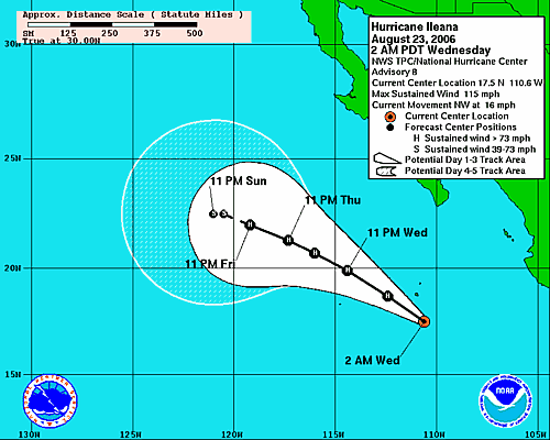
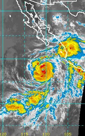
Hurricane Ileana has strengthened considerably since yesterday morning and has moved northwestward faster than forecast yesterday. Early this morning Ileana was a strong Cat 2 storm with estimated winds of 100 kt with gusts to 120 kt. The official NHC forecast calls for her to be located near 19.9 N and 114.4 W at 24 August 0600 UTC as a Cat 3 storm. The track forecast is shown in Fig. 1 IR satellite imagery from 1030 UTC (Fig. 2) this morning indicates that Ileana may be moving northward slightly to the east of the forecast track. Also of interest is the associated large mass of clouds and thunderstorms to the northeast of Ileana over west-central Mexico and also south of the Gulf of California. All of the above indicates that Ileana should trigger a significant northward surge of moisture that would reach into the lower Colorado River region by tomorrow morning.
However, the dilemma here is that high amounts of moisture and precipitable water are already present over much of the southwest U.S. So what impacts might be expected? I am going to guess that Ileana will result in increased moisture advecting into the lower Colorado River Basin, southern Nevada, and the southern California deserts. A distinct surface surge may be more difficult to detect, but one is certainly possible. Watch Art Douglas' surge index on the Creighton Univ. web page at:
http://whistler.creighton.edu/products/name/Yuma_Gulf_Surge_Index/
However, the dilemma here is that high amounts of moisture and precipitable water are already present over much of the southwest U.S. So what impacts might be expected? I am going to guess that Ileana will result in increased moisture advecting into the lower Colorado River Basin, southern Nevada, and the southern California deserts. A distinct surface surge may be more difficult to detect, but one is certainly possible. Watch Art Douglas' surge index on the Creighton Univ. web page at:
http://whistler.creighton.edu/products/name/Yuma_Gulf_Surge_Index/
Tuesday, August 22, 2006
Brief review of yesterday and last night's weather
There was much more storm activity yesterday over south central and southeast Arizona than there was on Sunday. The "favorables" dominated yesterday apparently and intense storms had developed by noontime. For Arizona there were quite a few severe reports during the afternoon. See the reports at:
http://www.spc.noaa.gov/climo/reports/yesterday.html
There were also a couple of measured severe gusts within the PRISMS mesonet in the Phoenix metro area that are not on the report map. A brief story and photo of damage in the Tucson area yesterday is at:
http://www.azstarnet.com/metro/143128.php
Here at the house there was much thunder from nearby cells early in the afternoon, but once again only wind and sprinkles and a trace of rain. However, the evening sounding was much moistened with considerable instability in all layers below 650 mb - nighttime/early morning storms developed and it was raining here at sunrise with 0.18" in the gauge.
The morning sounding at Tucson exhibits a very nice "onion" sounding with a deep, ice saturated layer producing anvil rainfall above the onion bulb. Sounding is at:
http://www.rap.ucar.edu/weather/upper/tus.gif
Today appears to favor a heavy rain threat in southeast Arizona, as the inverted trough at 700 mb that brought a favorable wind profile for severe storms yesterday has moved on to the west. The western lobe of the 500 mb subtropical high is over southeastern Utah this morning, and the weak trough separating this anticyclone from the larger anticyclone over the Southern Plains appears to be between here and Phoenix. Thus, winds aloft are very light and variable up to about 300 mb and storms should be very slow moving in this part of Arizona today.
Tropical Storm Eleana is predicted to become a hurricane shortly and the NAM and NHC forecast the storm to move northwestward and to come north of 20N. Thus, this storm may come close enough to the south end of Gulf oc California to trigger yet another push of deep tropical moisture into Arizona Friday or over the weekend.
http://www.spc.noaa.gov/climo/reports/yesterday.html
There were also a couple of measured severe gusts within the PRISMS mesonet in the Phoenix metro area that are not on the report map. A brief story and photo of damage in the Tucson area yesterday is at:
http://www.azstarnet.com/metro/143128.php
Here at the house there was much thunder from nearby cells early in the afternoon, but once again only wind and sprinkles and a trace of rain. However, the evening sounding was much moistened with considerable instability in all layers below 650 mb - nighttime/early morning storms developed and it was raining here at sunrise with 0.18" in the gauge.
The morning sounding at Tucson exhibits a very nice "onion" sounding with a deep, ice saturated layer producing anvil rainfall above the onion bulb. Sounding is at:
http://www.rap.ucar.edu/weather/upper/tus.gif

Today appears to favor a heavy rain threat in southeast Arizona, as the inverted trough at 700 mb that brought a favorable wind profile for severe storms yesterday has moved on to the west. The western lobe of the 500 mb subtropical high is over southeastern Utah this morning, and the weak trough separating this anticyclone from the larger anticyclone over the Southern Plains appears to be between here and Phoenix. Thus, winds aloft are very light and variable up to about 300 mb and storms should be very slow moving in this part of Arizona today.
Tropical Storm Eleana is predicted to become a hurricane shortly and the NAM and NHC forecast the storm to move northwestward and to come north of 20N. Thus, this storm may come close enough to the south end of Gulf oc California to trigger yet another push of deep tropical moisture into Arizona Friday or over the weekend.
Monday, August 21, 2006
Postmortem of yesterday and overview of morning observations today
Part 1 - Postmortem of yesterday: Storms were not widespread yesterday and a tropical-like squall did not materialize. So, yet another overly optimistic outlook - it's been a very tough summer for forecasting down here. Thunderstorms did move from the Catalinas into town last evening, and the airport got a direct hit by a storm with a moderate downburst and 0.33" of rain. I shot a photo of this storm at about 7pm when it was just west of the airport (i.e., looking south from our house) - CLICK HERE The simultaneous radar depiction of the storm CLICK HERE shows both the storm in the photo, and also the limited extent of local storm activity. As usual, we had about two hours of thunder here at the house, outflow, a sprinkle (trace of rain) and a great rainbow.
The most negative aspect of the day was the evolution of the thermodynamics during the afternoon (we knew we were dealing with a marginal wind profile). By evening, the Tucson sounding CLICK HERE showed drying had occurred during the day below 600 mb and that the afternoon BL was characterized by a moisture profile that was not well-mixed. This is a difficult negative to overcome, and the storm that made it to airport must have been propagating with a fairly strong downdraft (as the gust to 33 kt at TUS indicates).
Part 2 - Overview of conditions this morning: This morning's Tucson sounding CLICK HERE indicates moistening up to 500 mb, no residual BL is present (meaning substantial heating will be needed to build a deep BL over lower elevations), and there are fairly strong southeasterly winds present below about 650 mb (i.e., a downslope direction). Winds at upper-levels have veered again and are southwesterly around a weak trough over the West (so there is a good shear profile, except for the weak winds present from 500 to 350 mb). The key forecast issue is whether a well-mixed BL will be able to develop in the face of the downslope winds. (Mike Leuthold - let us know what the WRF model does if you can find time.)
On the larger-scale, standard level charts we find that:
At 700 mb: An anticyclone centered near Las Vegas is affecting most of Arizona, except the far southeast where the inverted trough over western Mexico appears to have resulted in southeast winds. The main anticyclone over southeast Oklahoma is separated from the western lobe (which actually has three weak centers) by a trough line extending from near Phoenix northeastward to east of Omaha. The 700 mb level is very moist at all sites upstream from Tucson (i.e., Albuquerque, El Paso, and Chihuahua MX).
At 500 mb: A western lobe of the anticyclone is centered in southern Utah, with a trough line separating it from the strong eastern anticyclone center over Oklahoma. This trough extends from near Tucson northeastward to central Nebraska. The southern part of this trough is an extension of the inverted trough over western Mexico - this trough appears to have moved westward away from the upper-level feature that has been nearly stationary for last couple of days over west Texas. Thus, the NAM may have it sort of right today, with the lower-level trough actually moving westward.
At 250 mb: The upper trough over west Texas/northeastern MX is very diffuse and hard to define - thus, this feature appears to be confined to the very upper troposphere, making it a likely non-player in the evolution of weather west of the Continental Divide. The TUTT seems very pronounced and shifted to a northerly location from central Mexico eastward across south Florida. Upper flow today is not nearly as diffluent as it was yesterday morning (a negative).
Why all this description? I think that today's 12 UTC observational data illustrate well how terribly difficult it can be to sort out all the potential interactions and evolutions of weak features which will come together to produce afternoon and evening thunderstorms. My gut says that today will be a much more active day than yesterday ended up being, but only time will tell which features dominate.
The most negative aspect of the day was the evolution of the thermodynamics during the afternoon (we knew we were dealing with a marginal wind profile). By evening, the Tucson sounding CLICK HERE showed drying had occurred during the day below 600 mb and that the afternoon BL was characterized by a moisture profile that was not well-mixed. This is a difficult negative to overcome, and the storm that made it to airport must have been propagating with a fairly strong downdraft (as the gust to 33 kt at TUS indicates).
Part 2 - Overview of conditions this morning: This morning's Tucson sounding CLICK HERE indicates moistening up to 500 mb, no residual BL is present (meaning substantial heating will be needed to build a deep BL over lower elevations), and there are fairly strong southeasterly winds present below about 650 mb (i.e., a downslope direction). Winds at upper-levels have veered again and are southwesterly around a weak trough over the West (so there is a good shear profile, except for the weak winds present from 500 to 350 mb). The key forecast issue is whether a well-mixed BL will be able to develop in the face of the downslope winds. (Mike Leuthold - let us know what the WRF model does if you can find time.)
On the larger-scale, standard level charts we find that:
At 700 mb: An anticyclone centered near Las Vegas is affecting most of Arizona, except the far southeast where the inverted trough over western Mexico appears to have resulted in southeast winds. The main anticyclone over southeast Oklahoma is separated from the western lobe (which actually has three weak centers) by a trough line extending from near Phoenix northeastward to east of Omaha. The 700 mb level is very moist at all sites upstream from Tucson (i.e., Albuquerque, El Paso, and Chihuahua MX).
At 500 mb: A western lobe of the anticyclone is centered in southern Utah, with a trough line separating it from the strong eastern anticyclone center over Oklahoma. This trough extends from near Tucson northeastward to central Nebraska. The southern part of this trough is an extension of the inverted trough over western Mexico - this trough appears to have moved westward away from the upper-level feature that has been nearly stationary for last couple of days over west Texas. Thus, the NAM may have it sort of right today, with the lower-level trough actually moving westward.
At 250 mb: The upper trough over west Texas/northeastern MX is very diffuse and hard to define - thus, this feature appears to be confined to the very upper troposphere, making it a likely non-player in the evolution of weather west of the Continental Divide. The TUTT seems very pronounced and shifted to a northerly location from central Mexico eastward across south Florida. Upper flow today is not nearly as diffluent as it was yesterday morning (a negative).
Why all this description? I think that today's 12 UTC observational data illustrate well how terribly difficult it can be to sort out all the potential interactions and evolutions of weak features which will come together to produce afternoon and evening thunderstorms. My gut says that today will be a much more active day than yesterday ended up being, but only time will tell which features dominate.
Sunday, August 20, 2006
Severe storms in southeast Arizona this afternoon?
Has been a busy week and I have not had a chance to do much here in blogland.
The morning observations today - Sunday August 20 - are very interesting and indicate some potential for a tropical-like squall and significant storms this afternoon.
The morning Tucson sounding, view at:
http://www.rap.ucar.edu/weather/upper/tus.gif
went bonkers above 350 mb, so we have to decide whether to accept the data below 350 mb as being good. If I accept the observations below 400 mb, it appears that CAPE is substantial for out here, that there are some easterly steering winds above well-mixed BL cloud base (~700 mb), and that anvil level flow is from the southwest (favorable).
The 500 mb anticyclone has a split off a lobe right over Phoenix this morning - not a favorable position. But, there is not a deep, barotropic anticyclone aloft over Arizona.There is a deep trof/shear zone from 700 to 200 mb over New Mexico between the large anticyclone to the east and features to the west. The flow above 300 mb appears highly difluent this morning (favorable). The weak flow in middle levels continues - the storms of August 8th got organized with similar weak flow, so we'll have to see what happens today.
The models at 0600 UTC provide little help - NAM continues with the near TS it has somehow genertaed off to the SSW. Thus, one has little feel for how much credance to give the predicted wind profiles. In general, the wind patterns predicted by GFS for this evening are less favorable than what's observed this morning.
Certainly should be a much more interesting day than have been the last couple of days, since the early morning deluge of Wednesday the 16th.
The morning observations today - Sunday August 20 - are very interesting and indicate some potential for a tropical-like squall and significant storms this afternoon.
The morning Tucson sounding, view at:
http://www.rap.ucar.edu/weather/upper/tus.gif
went bonkers above 350 mb, so we have to decide whether to accept the data below 350 mb as being good. If I accept the observations below 400 mb, it appears that CAPE is substantial for out here, that there are some easterly steering winds above well-mixed BL cloud base (~700 mb), and that anvil level flow is from the southwest (favorable).
The 500 mb anticyclone has a split off a lobe right over Phoenix this morning - not a favorable position. But, there is not a deep, barotropic anticyclone aloft over Arizona.There is a deep trof/shear zone from 700 to 200 mb over New Mexico between the large anticyclone to the east and features to the west. The flow above 300 mb appears highly difluent this morning (favorable). The weak flow in middle levels continues - the storms of August 8th got organized with similar weak flow, so we'll have to see what happens today.
The models at 0600 UTC provide little help - NAM continues with the near TS it has somehow genertaed off to the SSW. Thus, one has little feel for how much credance to give the predicted wind profiles. In general, the wind patterns predicted by GFS for this evening are less favorable than what's observed this morning.
Certainly should be a much more interesting day than have been the last couple of days, since the early morning deluge of Wednesday the 16th.
Sunday, August 13, 2006
Mike Leuthold said:
This is a re-post of Mike's comment with the urls activated.
The NAM has had terrible initializations for most of the last week with a semi permanent strong inverted trough in various random parts of northern Mexico. The result of this is that mid level forcast winds have been much stronger (up to 30kts) that what has actually happened, and these winds then caused storms in the model to organize and propagate into the lower elevations, which hasn't happened. The NWS had bit at these poor forecasts more than once with high pops for low elevations and even a mention by SPC sometime last week that the forecast shear was high.This is a link to a model sounding over Mt Lemmon made from the 12z NAM from the previous day (6 Aug).
http://tinyurl.com/n8gkx
This is the actual sounding.
http://tinyurl.com/p2mzx
Perhaps the NWS should put some effort and money into supporting northern Mexico soundings during the summer. The above cases show how poor the models perform when there are no soundings from there. It would be money well spent.
11:59 AM
The NAM has had terrible initializations for most of the last week with a semi permanent strong inverted trough in various random parts of northern Mexico. The result of this is that mid level forcast winds have been much stronger (up to 30kts) that what has actually happened, and these winds then caused storms in the model to organize and propagate into the lower elevations, which hasn't happened. The NWS had bit at these poor forecasts more than once with high pops for low elevations and even a mention by SPC sometime last week that the forecast shear was high.This is a link to a model sounding over Mt Lemmon made from the 12z NAM from the previous day (6 Aug).
http://tinyurl.com/n8gkx
This is the actual sounding.
http://tinyurl.com/p2mzx
Perhaps the NWS should put some effort and money into supporting northern Mexico soundings during the summer. The above cases show how poor the models perform when there are no soundings from there. It would be money well spent.
11:59 AM
Subscribe to:
Posts (Atom)