Thursday, September 29, 2016
Quick Look At today's Difficult Setting
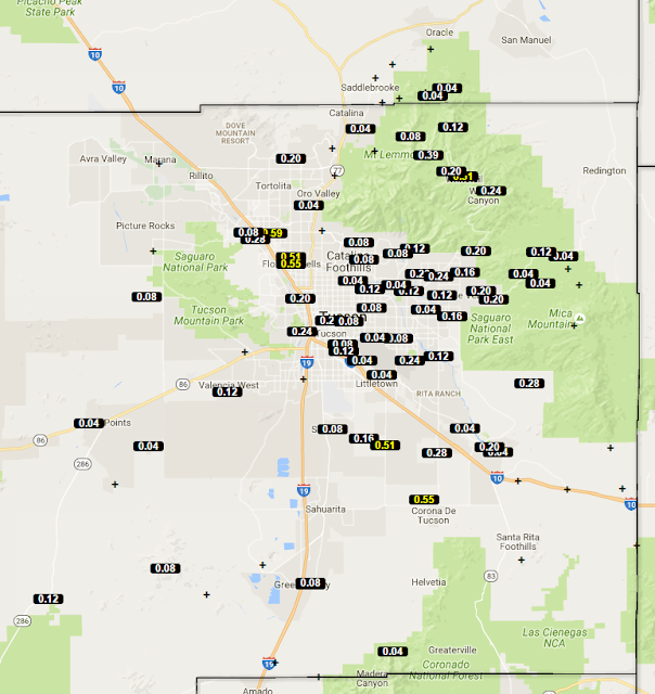
Fairly widespread rains yesterday as there were a number of thunderstorms in eastern Pima County. Amounts were mostly light, but I see six ALERT sites had more than half an inch for 24-hours ending at 7:00 am MST (above). Here at house we had thunder and several slight power surges, but only 0.03". The plot of detected CG flashes for 24-hours ending at 7:00 am (below, from Atmo and Vaisala) indicates an active, late September day for much of the state.
Morning showers again (composite radar above for 7:08 am) will complicate today's forecast. This morning's TWC upper-air sounding indicates over 1.40 inches of PW with CAPE between 500 and 1000 J/kg, and the WRF models (from both 00 and 06 UTC runs) forecast thunderstorms again this afternoon over eastern Pima County. The WRF-NAM versions forecast quite strong storms, while the GFS version forecasts are not nearly as impressive.
However, none of the WRF forecasts did well with the morning showers. Only the 00 UTC WRF-NAM forecast early am showers, but they occurred several hours too soon and moved rapidly off to the northwest. Below is the forecast of OLR (W/m**2) from the 00 UTC WRF-NAM valid at 7:00 am - compare to visible satellite image (above) for nearly the same time. There is much more cloudiness over southeast Arizona than the model forecasts indicated. Best strategy now is to watch the observations and wait for the 12 UTC WRF forecasts.
Subscribe to:
Post Comments (Atom)


No comments:
Post a Comment