Friday, December 05, 2014
Showers Or Sprinkles Tomorrow?
Has become a dreary day with cirrus spreading over Arizona from the Pacific, as another weak short-wave approaches at middle and upper levels. View from Kitt Peak above is from 10 am MST. Visible satellite image below is from 9:30 am and shows deep convection west of California.
Graphic above shows detected CG flashes during the 12-hours ending at 9 am MST. The MIMIC PW from CIMSS at University of Wisconsin, below, shows a substantial blog of higher PW west of California and another broad plume of tropical moisture spreading northeastward west of Baja. Key issue for tomorrow will be whether or not this southern plume makes it into Arizona. The new run of the WRF-NAM this morning forecasts light showers and sprinkles across eastern Pima County late tomorrow morning - forecast of composite radar at bottom is valid at 10 am MST tomorrow (Saturday, December 6th).
Much Needed Rain Across Eastern Pima County
Rain had ended here at the house by 1 pm MST yesterday and by 3 pm (above) skies were mostly clear, clean, and sparkling, bringing a beautiful afternoon and evening to Tucson area. Here at the house our rain totaled up to 0.88". Across the ALERT network amounts were heaviest over the Catalinas, reaching almost three inches at two stations. Across the low elevation metro area amounts were generally between a half and one inch. However, across the southern portions of the network amounts were lighter, generally less than half an inch. The rainfall sector plots from ALERT below are for the period midnight through 6 pm MST on Thursday, December 4th - top Catalinas; middle west Metro; bottom east Metro.
Meanwhile, on the other side of the Pacific, Super Typhoon Hagupit is approaching the Phillipines. IR image above shows the storm and graphic below is the current forecast for the storm from the Joint Typhoon Warning Center. Last year Super Typhoon Haiyan crossed the island chain in early November, causing massive destruction and thousands of deaths.
Thursday, December 04, 2014
Rain Across Much Of Southeastern Arizona This Morning
Weak short-wave at 500 mb will move rapidly across Arizona today, interacting with the tropical moisture plume we've been following past few posts. The NAM 500 mb analysis at 12 UTC (above) shows the short wave approaching Arizona - current NAM forecast is for it to move to central New Mexico by evening. The plume of very high (for December) PW extends into much of Arizona with PWs of more than an inch - analysis below is blended PW at 13 UTC from CIRA at Colorado State with greens indicating PWs of an inch or more..
Composite radar (above) from NWS TUS at 7:18 am MST indicates rain and some heavier showers across most of Pima County - there have been lightning flashes and thunderstorms out to the west and northwest during the early morning hours.
So far (through 7:20 am) amounts over the city have been around 0.25 to 0.30", but with rains continuing. All but 4 ALERT stations had recorded rain through 7 am. Amounts were highest over the Catalinas (above). Graphic below shows rain amounts so far over the west central part of City and on out to west. So far, a nice and very welcome rain event - our first in many weeks.
Wednesday, December 03, 2014
Light Showers Across Pima County
There were light showers and sprinkles across the area last evening and during the night. Most places recorded only a Trace (as we did here at house). There were 10 of 92 ALERT stations that recorded 0.04" or more for past 24-hours. These were in the Catalinas and the southwest sector of the network - 3 sites measured just over 3/10 of an inch.
This morning the tropical moisture plume has reached into the Southwest, with PW greater than an inch (greens) over most of southwestern Arizona (29 mm here at TWC this morning). The GPS system on campus has been down for quite a long while. Above is blended PW analysis from CIRA at Colorado State valid at 12 UTC.
The early WRF-NAM forecasts the plume to move across southern Arizona tomorrow and also to weaken as it does. Forecast below is of PW on the 5.4 km grid and is valid at 5 am MST.
The best chances for area-wide rainfall occur tomorrow as what is left of the Pacific cyclone moves across Arizona as a weak short-wave. The WRF-NAM forecast above is for composite radar echoes and is valid at 9 am MST on Thursday the 4th. Below is the WRF-NAM forecast of rainfall amounts through 11 pm on Thursday night, with some decent amounts forecast for lower elevations. Last rainfall here at the house was back on October 19th - so some real rain would be very nice.
This morning the tropical moisture plume has reached into the Southwest, with PW greater than an inch (greens) over most of southwestern Arizona (29 mm here at TWC this morning). The GPS system on campus has been down for quite a long while. Above is blended PW analysis from CIRA at Colorado State valid at 12 UTC.
The early WRF-NAM forecasts the plume to move across southern Arizona tomorrow and also to weaken as it does. Forecast below is of PW on the 5.4 km grid and is valid at 5 am MST.
The best chances for area-wide rainfall occur tomorrow as what is left of the Pacific cyclone moves across Arizona as a weak short-wave. The WRF-NAM forecast above is for composite radar echoes and is valid at 9 am MST on Thursday the 4th. Below is the WRF-NAM forecast of rainfall amounts through 11 pm on Thursday night, with some decent amounts forecast for lower elevations. Last rainfall here at the house was back on October 19th - so some real rain would be very nice.
Tuesday, December 02, 2014
Tropical Moisture Plume Has Moved Directly Northward
EDITED at 9:30 am MST - have added the new NAM forecast of precipitation through 5 am on Friday, the 5th, since it is so different than the GFS. See below.
The moisture plume from low-latitudes that I showed in yesterday's post has moved northward, directly toward the LA Basin during past 24-hours. The graphic above is from CIRA (at Colorado State) and shows their blended PW analysis for 12 UTC this morning (December 2nd). This is a very impressive moisture intrusion and it will serve to increase the chances of rainfall across Arizona as the week progresses. Graphic below shows CG lightning flashes detected for 12-hours ending at 1:30 am MST this morning. There was considerable thunderstorm activity west and southwest of California during the night - both directly associated with the Pacific 500 mb cyclone and also within the tropical moisture plume.
The forecast models continue to weaken the cyclone rapidly as it begins to move toward the coast today, But the GFS has begun to again forecast rainfall over the Southwest, as the weakened short-wave moves across northern Arizona (GFS had gone dry for the last couple of days, after earlier forecasts that had indicated both the moisture plume and rainfall coming into Arizona). The GFS operational forecast from 00 UTC last evening (above)now forecasts a widespread precipitation event for Arizona for period ending 5 am MST on Friday the 5th. So, it appears that the most interesting weather for southern Arizona will occur from late tomorrow into Thursday.
Below is the NAM forecast from 12 UTC this morning for precipitation through 5 am MST on Friday, i.e., for period ending at same time as GFS forecast shown above. Although NAM forecasts moisture plume to affect all of Arizona, it only forecasts precipitation for the higher elevations of northern Arizona - so two quite different model forecasts.
Monday, December 01, 2014
High Clouds from Pacific Over Tucson Area And Much Of Southwest
We've been away a couple of days but are now back after the Holiday and looking forward to a new month.
December starts here with a fairly wide-spread cloud cover, high clouds and some middle clouds, intruding into the Southwest. Visible image above is from 8 am MST this morning (December 1st).
The MIMIC PW analysis from CIMSS (Univ. of Wisconsin - below) is for 12 UTC this morning. The large closed low apparent to the west of California is forecast by current model runs to weaken rapidly as it moves eastward. This circulation has a narrow atmospheric river wrapping into it. However, a much more substantial and broad moisture plume from low-latitudes is pushing northeastward toward southern California and models indicate that this plume will also wrap into the weakening middle and upper level system. This moisture will spread over Arizona tomorrow, bringing an unsettled day with some winds, virga, mammatus, and some light showers.
The early run of the WRF-NAM at Atmo forecasts a fairly rapid moistening of the atmosphere as the moisture plume moves overhead tomorrow - above is the model's forecast of the sounding for TUS at 5 pm tomorrow. PW has increased from only 7 mm at initialization time to almost 30 mm. The model does not develop much in the way of CAPE, but the deeply saturated environment (assuming the forecast verifies well) should support some showers. The model's forecast of accumulated precipitation (below) through 11 pm Wednesday night keeps meaningful precipitation to our north. However, the forecast appears a bit conservative to me, given the forecast sounding, so tomorrow may be more unsettled than indicated by the forecast model.
Thursday, November 27, 2014
Turkey Day 2014
Low temperatures here at house continue to slowly moderate - low this Thanksgiving Holiday came in at 28 F.
The operational GFS continues to forecast some light rain for southern Arizona at the start of Dec - above is forecast of total precipitation through the next 8 days. However, the ECMWF has trended to a dry start for next month. Looks like November will close out with a big goose egg for rain here at the house - not even a day with a Trace.
Gould's turkey in free flight above. Wishing all a great Holiday and condolences to the increasing numbers of folks who have to work today.
The operational GFS continues to forecast some light rain for southern Arizona at the start of Dec - above is forecast of total precipitation through the next 8 days. However, the ECMWF has trended to a dry start for next month. Looks like November will close out with a big goose egg for rain here at the house - not even a day with a Trace.
Gould's turkey in free flight above. Wishing all a great Holiday and condolences to the increasing numbers of folks who have to work today.
Wednesday, November 26, 2014
CFSv2 Forecast For TUS Dec-Feb
First a note about low temperatures this morning - low here at house was 24 F, while low at TUS was 35 F. The cold station out in the San Pedro Riparian Area came in at 19 F this morning.
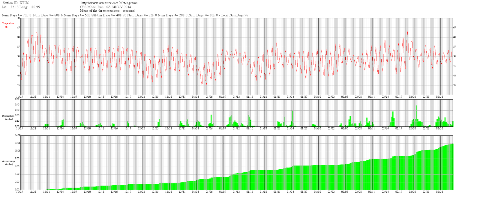
Art Douglas sent the above forecast this morning which is from the CFSv2 model that is run at the CPC. The forecast is for TUS and indicates a very wet winter, were it to verify. The graphic is hard to read here, but the accumulated precipitation forecast at the airport reaches 12 inches by the end of February!
Tuesday, November 25, 2014
Bit More On Morning Cold Spots
First, the morning low (am on November 25th) here, near the Rillito Wash, was 23 F. This makes 7 of last 8 mornings having temperatures here down in the 20s (other morning came in at 30 F). Plot below of morning low temperatures for the 25th, from MesoWest, is centered on the San Pedro Riparian Area - where lows have been very cold the last two mornings (9 F yesterday at station east of Tombstone and 11 F this morning).
Russ Scott provided the following:
--------------------------------------------------------
Art Douglas noted: "El Ninos frequently bring early cold and we are sure doing that this year in some parts of the SW. Attached is this morning's low temp map for Mexico (below)."
Russ Scott provided the following:
Hi Bob.
Following up on yesterday’s low temp along the San Pedro:
Here’s a plot (above) of yesterday’s low at my research
site along the San Pedro River. This mesquite bosque site is quite
close, 5 km south, of the Fairbank station shown on your Mesonet. The
San Pedro temp in the plot below is actually measured
at 8 m height, at mid-canopy position, so a temp measurement at the
standard screen height would be even colder than this.
The second plot (below) shows how effective these hard
freezes, which started more than a week ago, are on damping latent heat
(water vapor) fluxes by putting an end to the mesquite transpiration for
the year. Because it is so cold at these bottom land
locations, the mesquite here don’t leaf out till late-April and don’t
start transpiring until mid- May.
Russ
Art Douglas noted: "El Ninos frequently bring early cold and we are sure doing that this year in some parts of the SW. Attached is this morning's low temp map for Mexico (below)."
Monday, November 24, 2014
More On Morning Lows
Russ Scott noted in a comment below:
Hi Bob.
That 10 degree F observation along the San Pedro (at Fairbank) would not at all surprise me. I have a flux tower a few miles south of that site also right along the San Pedro and on a night like last night it is 15 to 20 degrees colder along the river than outside the riparian bottomland. I'll be able to check that when the data comes in tonight.
Stay warm,
Russ
-------------------------------------------------------
I have posted a plot of minimum temperatures observed during the past 24-hours at MesoWest stations across southeast Arizona. Russ' comments are about the station in the San Pedro Riparian area that shows a min temperature of 9 F this morning. This is certainly a really cold spot if the observation holds up.
There were quite a few freezing and below temperatures across the colder parts of the metro area this morning (the blue shades).
Coldest Morning Of Fall Here
Coldest morning of year so far this Fall here on north side of Tucson along the Rillito Wash. Low temperature here at house fell to 21 F, making the morning 4 F colder than the lows on the 17th and 18th. There is a light touch of frost on roofs, cars, and trash bins, even though dewpoints are very low. Quick look at early WRF indicates that the model forecasts this to be the coldest morning, with temperatures up a bit tomorrow because of easterly winds. That will probably be tough to call, since some low spots may go calm, with colder temperatures than model forecast. The two plots are from MesoWest and show plots of surface conditions at about 7:30 am MST. Above is broad view and below is zoomed on Tucson metro. Many temperatures around in the 20s, with some teens over toward Benson. One station was reporting 10 F, but that looks suspicious.
Sunday, November 23, 2014
Roger Edwards Comments
Roger wrote:
Hear, hear. This has been not just a pet peeve of mine, but a problem in operational meteorology, for a long time. "Energy" has no meaning. The similarly used "dynamics" doesn't either. The chart being showed presumably involves vorticity. If "vorticity" is too big a word for the public--and I understand that--then don't show that chart to begin with. Instead show something else, such as temperature or wind, that is more conceptually comprehensible and isn't perceived as dense meteorological jargon.
From a recent BLOG esssay of mine:
BAD WORDING: “Energy” in the context of perturbations or the instability they may cause, such as upper-level energy approaching.
REASONING: Same as with “dynamics”, but worse. Energy, in many forms, is everywhere in the atmosphere! As such, this word is meaningless.
BETTER ALTERNATIVE(S): As with “dynamics”, this depends on the specific situation. Just state the actual feature or process involved. A more-informed reader is…a more-informed reader!
His complete blog post presents a lengthy list of sloppy/poor terminology he has seen in NWS FDs and can be found at:
http://stormeyes.org/wp/2014/05/toward-more-accurate-forecast-discussions/
I took a look at some more FDs yesterday afternoon and found several discussions throwing around the "energy" term. Interestingly, I found an FD from Boulder/Denver that used the term "moisture wave," as well as "energy."
Apparently the use of "energy" terminology is becoming fairly common within the NWS. I just took a look at the FD from one of National Centers and found:
Hear, hear. This has been not just a pet peeve of mine, but a problem in operational meteorology, for a long time. "Energy" has no meaning. The similarly used "dynamics" doesn't either. The chart being showed presumably involves vorticity. If "vorticity" is too big a word for the public--and I understand that--then don't show that chart to begin with. Instead show something else, such as temperature or wind, that is more conceptually comprehensible and isn't perceived as dense meteorological jargon.
From a recent BLOG esssay of mine:
BAD WORDING: “Energy” in the context of perturbations or the instability they may cause, such as upper-level energy approaching.
REASONING: Same as with “dynamics”, but worse. Energy, in many forms, is everywhere in the atmosphere! As such, this word is meaningless.
BETTER ALTERNATIVE(S): As with “dynamics”, this depends on the specific situation. Just state the actual feature or process involved. A more-informed reader is…a more-informed reader!
His complete blog post presents a lengthy list of sloppy/poor terminology he has seen in NWS FDs and can be found at:
http://stormeyes.org/wp/2014/05/toward-more-accurate-forecast-discussions/
I took a look at some more FDs yesterday afternoon and found several discussions throwing around the "energy" term. Interestingly, I found an FD from Boulder/Denver that used the term "moisture wave," as well as "energy."
Apparently the use of "energy" terminology is becoming fairly common within the NWS. I just took a look at the FD from one of National Centers and found:
EXTENDED FORECAST DISCUSSION
NWS WEATHER PREDICTION CENTER COLLEGE PARK MD
1057 AM EST SUN NOV 23 2014
VALID 12Z WED NOV 26 2014 - 12Z SUN NOV 30 2014
THE PASSAGE OF TIME IS DOING REMARKABLY LITTLE TO RESOLVE THE AREA OF SIGNIFICANT SPREAD THAT GUIDANCE HAS PERSISTENTLY BEEN SHOWING
OVER THE NWRN CONUS/SWRN CANADA AS OF EARLY DAY 3 WED WITH DOWNSTREAM IMPACTS ON THE
MID LVL ENERGY/SFC SYSTEM TRACKING INTO
THE GRTLKS AND SYSTEM THAT MAY TRACK NEAR THE EAST COAST EARLY IN ……
…..RECENT TRENDS TOWARD A BETTER DEFINED REXBLOCK PATTERN IN THE ERN PAC DURING THE FIRST HALF OF THE PERIOD LEAD TO A SLOWER TREND
WITH THE EVENTUAL PROGRESSION OF ERN PAC
TROUGH ENERGY TOWARD THE WEST COAST BY NEXT WEEKEND IN RESPONSE TO UPSTREAM PAC FLOW.......
Unfortunately, so it goes.
Saturday, November 22, 2014
More "Energy" Jargon From NWS Tucson
Today's weather feature from NWS Tucson shows a figure (above) that is labeled "Mid-level Energy for Today." However, that's not what this chart shows. In fact, if general readers want to look up what "energy" refers to here, they could go to the NWS Glossary of terms -
http://w1.weather.gov/glossary/
However, they will find no entry for "energy" since there are many types (e.g., nuclear energy, kinetic energy, etc.). One can find an entry in the glossary for "kinetic energy" and might possibly assume that this is what is shown on this graphic. But, no - the text on this graphic is just a sloppy use of technical jargon that has no exact meaning.
The chart is actually the NAM analysis of 500 mb winds, heights and vorticity (and as indicated on the graphic it is actually an analysis of geostrophic absolute vorticity). The NAM analysis is shown below. The NWS NAM display can also be criticized for incomplete legends - i.e., bar graphic at left has omitted the power of 10 portion of the magnitude and the units. But, it is a professional chart that is far better than the local chart with its erroneous terminology.
Arizona VS Utah Likely To Be Sloppy/Cold
Edited to add graphic of SLC NWS radar at game time.
Arizona and Utah meet this afternoon (at Utah) in an important football game for both teams. Weather looks like it will provide a serious challenge for both the teams and the fans, as a cold front and precipitation are approaching northern Utah. Current NWS forecast for a grid near the University is shown above - wind, rain, and then wet snow for the game.
I took a look at the early WRF-NAM (forecast on 5.4 km grid, initialized at midnight last night) and the forecast above shows radar echoes forecast for 2 PM MST today - near start time of the game. Definitely wet and cold and possibly turning white by the time the game ends. Forecast below shows accumulated precipitation for period ending at 5 pm. I see that this morning's line is Utah by 4 1/2 and wonder if the line considered the forecast for a sloppy situation?
As for yesterday's short-wave here in southeastern Arizona - the system brought little in the way of showers for most of eastern Pima County. But, there were showers and thunderstorms to the south and southwest of Tucson during the evening. Rain was measured at 6 of the 92 ALERT sites over the far southwest part of the network. The plot of detected CGs above is for period ending at midnight last night and indicates thunderstorms along the border and in northern Sonora, as the wave passed by.
Friday, November 21, 2014
Model Flip-Flops - Short Term And Long
Noticed two examples of numerical model flip-flops this morning for consecutive runs of both the WRF-NAM (short term forecast) and the ECMWF (long term global forecast).
First the WRF-NAM forecasts for this afternoon (Friday, November 21st). Above graphic shows accumulated precipitation through midnight tonight from the forecast run initialized at 12 UTC yesterday morning - with the model squeezing out a precipitation event for eastern Pima County as a moisture-starved short wave passes by. However, the current early run of same model (below), initialized at midnight this morning, forecasts only a bit of rain by midnight tonight over the far southeast corner of the state.
The changes in the forecasts reflect changes within the NWS NAM forecasts, since the high resolution WRF is driven by the lower resolution NAM model. Current forecasts for this afternoon, if they verify, indicate an unsettled situation with fits of wind, virga, mammatus, and some sprinkles around eastern Pima County.
At the global scale, the ECMWF has been forecasting a nasty winter storm along the Front Range of the Rockies for Thanksgiving day. The two panels shown above are from the ECMWF forecasts initialized at 12 UTC yesterday morning (500 mb at left and surface with 1000-500 mb thickness at right). The forecast is valid at 5 am MST on Thanksgiving day, and indicates strong, cold upslope flow and a nasty snow storm from Wyoming down to northern New Mexico.
However, the forecast that was initialized at 00 UTC last evening (below, same panels valid at 5 pm on Thanksgiving day). Has a completely different forecast (this flip-flop taking the ECMWF into sync with the GFS forecasts of past few days). So the current forecast from the ECMWF would bring a mild Thanksgiving day for the Front Range with some downslope, Chinook winds. This is one of the largest run-to-run flip-flops by the ECMWF that I can recall.
So many uncertainties still exist in weather forecasting for some situations - both for short and long terms.
Subscribe to:
Posts (Atom)