Thursday, June 23, 2016

Off Topic - Delayed Travelogue


During the first period of 110+ June days we were away from June 2nd to 4th visiting the La Posada Hotel again. See http://www.laposada.org/ to learn of the history of the famous hotel designed by Mary Colter. The Santa Fe Railroad nearly destroyed the building and used it as an office complex. It was luckily saved and has been mostly restored - it's just down the eastbound side of old Highway 66 from the "Standing on the Corner" statue. The once-per-day east and west bound Amtrak passenger trains still stop at the Hotel.


We went out early on June 3rd to watch the eastbound train come in  about 5:30 am. We met an Irishman who is on a cross-US adventure by bicycle and occasional train/bus legs. Katie is talking to him above as a number of travelers waited on the late train. His bicycle and small, bright yellow trailer are down the wall at the gate. His name is Paul Gillespie and he's blogging about his adventures, and many misadventures also. See   www.gap21.blogspot.com  He's not finding Amtrak employees particular helpful for his kind of travel and equipment.


Katie is getting shots of the arriving train above - which pulled in a bit over an hour behind schedule. Paul is shown below heading toward the baggage car in hopes of getting his bike and trailer on board - but the Porter refused and we last saw him pedaling toward Holbrook along the shoulder of I-40.


After breakfast at the wonderful Turquoise Room restaurant in the Hotel, we drove over to Flagstaff and visited the Museum of Northern Arizona in the north part of town. It was well worth the drive, since the museum is very scenic as well as historic and  a nice escape from the gridlock crush of the main part of town. We avoided this by leaving the interstate early and driving mostly residential streets across the north part of town. Info about the museum at  https://musnaz.org/


When we headed back for Tucson we went through Holbrook and swung into the famous Wigwam Motel on old 66 - still in business after all these years!

When we pulled up at the house here on the afternoon of the 4th, the car thermometer was saying the temperature was 113 F - so back to the desert and the worst aspect of June.


Wednesday, June 22, 2016

Monsoon-Type Pattern Continues But ...


The graphic above (from Atmo and Vaisala) shows detected CG flashes for the 12-hours ending at midnight last night. There was a bit of thunderstorm activity yesterday along the Borderlands and in the Santa Rita Mountains. 

The MIMIC PW analysis (from CIMSS at University of Wisconsin) for 4:00 am MST this morning is shown below. PW values are generally over an inch across southern Arizona and southern California, but the boundary layer (BL) is very deep with low RH near the surface. Much high PW is lurking over the southern 2/3rds of the GoC.

Even though we are in a monsoon-type summer pattern, there has been only isolated storm activity due to limited CAPE. Needed is an influx of higher moisture and/or cooler middle-level temperatures. A bit of both would be a big help. 

There is nothing much showing up in the long-range range forecasts that would trigger a serious push of deeper moisture into southern Arizona (culprits are usually TS near Baja or deep inverted troughs moving across northern Mexico). Second graphic below shows the GFS ensemble average 500 mb chart valid next Sunday afternoon. It appears that we will have to rely on MCS outflows to get the moisture up some - these can come directly into southeastern Arizona from Mexico, or they can push westward into the GoC and force low-level flow up the gulf.


The GEFS plumes provide forecasts for a number of parameters and the two plots here show PW above and CAPE below (both from 06 UTC last night). The models forecast PW to stay around 1.1 inches or a bit below 30 mm. The CAPE jumps up and down some, but the average generally stays below 400 J/kg - not very exciting for low elevations. So, best we can do is watch day-by-day and hope for some large MCSs in Sonora. (Disclaimer - I do not know how the GEFS algorithms compute CAPE and have to admit that I don't have the energy to try find documentation - my guess would be some that it's surface based but that's just a guess.)


Tuesday, June 21, 2016

Overview Of Yesterday's "Event"


There were some thunderstorms in eastern Pima County and Santa Cruz County (24-h CG flash density above from weather.graphics and Vaisala) yesterday afternoon. These produced mostly virga or sprinkles. The Nogales Airport recorded 0.03". Several spots in and near the Catalinas had light but measurable rain - two sites in the ALERT Network had rain, with Samaniago Peak reporting 0.12". The MesoWest surface networks showed three more sites around south and west end of the mountains with very light rainfall. We had a light shower here at a bit after 7:00 pm MST - my perhaps optimistic measurement indicates 0.01".

The 06 UTC WRF forecasts for today shift the activity northwestward, with just some isolated showers over higher elevations of southeast Arizona.

Monday, June 20, 2016

Some Shallow, Warm-Top Thunderstorms Around Area


A bit more high-based activity this afternoon than I'd expected - above is view of Catalinas at 5:40 pm MST showing Cu with bases at about 500 mb. Below is view looking south from Kitt Peak at about the same time - note all the smoke from the Brown wildfire, burning on east slopes of the Baboquivari Mountains.


The 00 UTC sounding from TWC this evening shows a small amount of CAPE from about 500 to 400 mb - but this is the - 10 to - 20 C layer so considerable ice in the low-topped buildups. Radar below verifies this and echo tops are generally below 30,000 msl. The airport carried TSTM in vicinity and there are definitely some spits and sprinkles and thunderstorms around eastern Pima County - as shown by CG flash density for 6-hours ending at 05:15 pm MST (second below). A bizarre day with a high of 112 F.


Moisture Increasing Some from The East

Yesterday's record highs (115 F here at the airport) resulted in several deaths - hikers and bikers apparently. Some MesoWest observations indicated highs of 120 F at spots in southern Arizona - but most of these are not validated observations. Regardless - extreme and dangerous heat continues.

There was again considerable smoke aloft at sunrise today, but NWS stations are apparently not reporting smoke aloft - would only happen with FAA enhanced observations or at sites with a human observer. Perhaps this also relates to the metar code for smoke - FU - you might ask where did that come from? Apparently from the French. Regardless, accurate surface observations at many locations this morning should have included - FULYR - meaning smoke layer, or layers, aloft.


The 12 UTC blended PW analysis from CIRA at Colorado State University (above)  indicates amounts of half to an inch over most of southern Arizona - some of this from the GoC and some from the east (GoM). Amounts of 30 mm and more appear distressingly far away.


The SPC 12 UTC morning sounding plot from on campus (TWC) above is equally distressing - no CAPE and several elevated mixed layers (EMLs) aloft, with the highest one extending well above 500 mb.

Both the WRF versions from 06 UTC forecast a smidgen of mid-level CAPE at 5:00 pm MST this afternoon, along with slightly higher PWs of just below an inch. Interestingly, the NAM version (below) brings the BL "moisture" in from the west, while the GFS version has easterly winds in low-levels. Regardless, perhaps enough moisture for there to be very high-based cumulus this afternoon, but chances for thunderstorms remain well to our north and south.


Sunday, June 19, 2016

Quick Update On The Extreme Heat

At noon today the temperature at TUS is 108 F - that is an amazing 6 F higher than it was at same time yesterday - note that high yesterday was 109 F.

At 6:30 am MST this morning (below) skies in our area were very smokey, as the plume from near Show Low drifted south during the night into eastern Pima County.


Saturday, June 18, 2016

Summer Pattern With Serious Heat

Summertime middle-level pattern (e.g., strong anticyclone) has setup with a vengeance today, with a nearly 6000 m high centered northeast of here. Morning 500 mb chart from NCAR above shows this summer pattern - aka the "monsoon" pattern. The GEFS average 500 mb heights forecast for 5 and 10 days are shown in two panels below - monsoon is with us now.


The latest forecast from the NWS for the airport (TUS) is really nasty (above) with the heat forecast to continue at deadly levels for the coming week - lowest high temperature forecast by NWS during the week is 108 F.


Of course, not much happens during summer until this pattern interacts with subtropical moisture and CAPE to produce thunderstorms and cooling rainfall (what most folks consider the monsoon begins when decent rains affect substantial areas of the state). The 1:00 pm MST CIRA blended PW analysis above shows very very dry air over the Four Corners with moister air (PWs near or above 1 inch) over southern California and  southwest Arizona. Generally PWs have to go above 30 mm (higher above often better) before much can happen at lower elevations.

The 12 UTC WRF-GFS forecast for PW at 3:00 pm on Monday afternoon is shown below. Moisture from the east sneaks into parts of Pima County, while moisture from the GoC gets into western half of the county. The WRF forecasts indicate thunderstorms moving from higher elevations into parts of the metro area later on Monday. These storms could produce very strong winds and dust and some spits and sprinkles of rainfall - chance for rain better at higher elevations. Regardless of details, Monday could be a really nasty day. The PW in the model forecasts goes just above 30 mm from 6:00 to 11:00 pm om Monday, due to moist outflows from the storms. There is another period with PW above 30 mm in the forecasts during the early morning hours of the 23rd, as moist sneaks in again from the GoC. But no serious influx of decent low-level moisture is in sight yet.


Tomorrow And Monday As Forecast By WRF-NAM


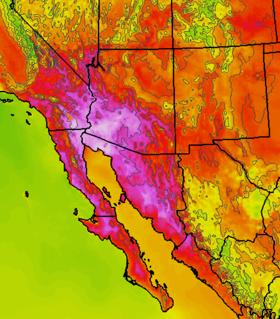
Have taken a quick look at the 06 UTC WRF-NAM forecasts from Atmo for tomorrow and Monday (June 19 and 20). Forecast above is 2-m temperature valid at 3:00 pm MST on Sunday - certainly not a good afternoon for anything outside, with deadly heat levels.


On Monday afternoon the WRF-NAM forecasts thunderstorms in Pima County - above forecast of composite radar echoes is valid at 6:00 pm. That model even puts down 1/10 inch of rain at airport. However, the GFS version is now much less active for Monday.

The forecast 2:00 PM skewT from the WRF-NAM is shown below. The well-mixed boundary layer is very deep , extending up to above 600 mb. The model computes CAPE of over 800 J/kg; however that number is an over-estimate and my eyeball says actual CAPE of about half that. Very hard to get much except wind and dust at low elevations with a sounding like this.


To see what NWS is actually forecasting for the airport, I had to dig around on their web page to find the hourly time-series of the grid point forecasts. Below is a snip from those plots showing Monday the 20th - blue is sky cover (%); green is RH (%); and brown is POPs (%). So the official forecast is for 5% POPs for a number of hours during Monday afternoon and evening.


Friday, June 17, 2016

From WRF-GFS: Intense Heat Pulls In Moisture Next Week

The intense heat over the weekend into early next week will be associated with a strong, middle-level anticyclone with low surface pressures over the deserts. Weak inverted troughs at 500 mb will move westward along the Borderlands and across northern Mexico. All of this combines in the 00 and 06 UTC model forecasts to pull low-level moisture into the Southwest, bringing another period of summer thunderstorms.


The QPF plumes from the GEFS forecasts at 06 UTC last night (above) indicate all of the ensemble members forecasting some rain at TUS for the period 21 through 25 June - amounts are not much, but at least the consensus is promising. The WRF-GFS forecast from Atmo at 00 UTC last evening forecasts some thunderstorms for southern Arizona as early as 5:00 pm on the 20th (Monday - below). If these storms do occur they will bring very strong outflows with blowing dust to the lower elevations.


The 00 UTC WRF-GFS forecast of PW (on the 5.4 km grid, above for 5:00 pm on the 21st) indicates moisture in southern Arizona coming from the eastern Pacific, the GoC, and also the GoM - an interesting situation. The model forecasts rainfall across much of the state during the period 20 to 24 June (below), with the more significant amounts at higher elevations.

Of course, these are longer-range forecasts, but at least the trend is for some relief from the heat and hopefully a smell of moisture and rain in the air by midweek.


Thursday, June 16, 2016

Wildfire Update


Edited to add: Visible image above is from 6:45 am MST this morning (17 June) shows the smoke from the three fires discussed below a bit after sunrise.


The above is a 00 UTC (5:00 pm MST) visible image that shows two major wildfire plumes very clearly. The one in Arizona is near Show Low and the one in New Mexico is the Dog Head fire southeast of Albuquerque. There is a third wildfire burning, the North fire near Magdalena, New Mexico, but it's smoke is hard to see because of light backgrounds and little contrast. Magdalena is west of Socorro and east of the Very Large Array (VLA) - think of the movie Contact, small portions of which were filmed at the VLA, and Carl Sagan.

Cedar Creek Fire And WRF-GFS Forecast For Sunday


The Cedar Creek fire in Navajo County threatens Show Low with possible evacuation alerts issued for the town this afternoon.


Mike Leuthold pointed out the amazingly high temperatures being forecast at 2-m by the WRF-GFS model for this coming Sunday afternoon - Father's Day. These two forecasts are valid at 4:00 pm MST Sunday, with above being the 1.8 km grid forecast and below being the regional view on the 5.4 km grid. Good grief, what a forecast!


Off Topic - Bird Watching


Was another cool and pleasant morning at sunrise and I took a number of photos of birds I saw while I walked along the Rillito. Above is a pair of what I think are juvenile Red Tail Hawks. These two usually hunt together, or very close to each other, and are still hanging around their parents' nest, which is in a large gum tree right at the end of Cactus at the wash. At bottom is a Vermilion Fly Catcher perched in a bright green mesquite tree.


Wednesday, June 15, 2016

Link From Pat Holbrook

Pat Holbrook has sent a link to a NOAA metadata site that I was not aware of - looks like an interesting site.


The information here indicates that the ASOS at TUS has remained at the same location on the airport since it went into service in 1996. 

The problems reported in the two links in previous post relate to the introduction of, and changes in, automated temperature monitoring systems used by the NWS at TUS prior to the installation of the current ASOS system. Locations and types of these various instruments are detailed in the article by Gall et al.

I am not sure if problems with the temperatures measured by the ASOS system have occurred or been documented since 1996. I thought that I had remembered a change in location of the TUS ASOS, but apparently I was remembering the shifts in the earlier automated instruments.

Tuesday, June 14, 2016

Comment re Tucson High Temperatures

From Russ Scott: Regarding the high temperatures, I remember when I moved here in 1995 that there was talk about the NWS moving the location of their official thermometer from over a tarmac or essentially paved location to a more natural desert surface. I don't know if this rumor is true, but it's why I've always thought that the record highs of ~115 we hit mostly in the early 90's turn out to be around 110-112 since then.

Of course, we'll probably get back to those records of 115 or more eventually as the climate continues to heat up, but the instrument move (if true) has set that back a couple of decades.

---------------------------------------------------------

Actually the history of maximum temperatures and record highs has a somewhat checkered history here at Tucson. Many (or most) of the issues arose after the NWS implemented its automated surface observing systems (ASOS). For some background on the controversies see the following links:


 I do think think the ASOS has been relocated at the airport one or two times, but don't know the details. Accurate metadata concerning NWS observations can be very hard or impossible to find. Perhaps other readers know the history of the observing sites at the airport during the ASOS era?

Shown below are the current ASOS location at the airport, as well as a zoom-in on the ASOS site that is northwest of the main runway.