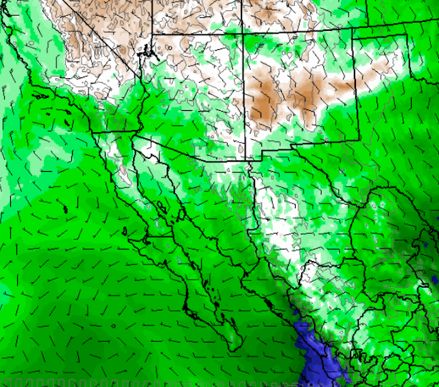
The intense heat over the weekend into early next week will be associated with a strong, middle-level anticyclone with low surface pressures over the deserts. Weak inverted troughs at 500 mb will move westward along the Borderlands and across northern Mexico. All of this combines in the 00 and 06 UTC model forecasts to pull low-level moisture into the Southwest, bringing another period of summer thunderstorms.
The QPF plumes from the GEFS forecasts at 06 UTC last night (above) indicate all of the ensemble members forecasting some rain at TUS for the period 21 through 25 June - amounts are not much, but at least the consensus is promising. The WRF-GFS forecast from Atmo at 00 UTC last evening forecasts some thunderstorms for southern Arizona as early as 5:00 pm on the 20th (Monday - below). If these storms do occur they will bring very strong outflows with blowing dust to the lower elevations.
The 00 UTC WRF-GFS forecast of PW (on the 5.4 km grid, above for 5:00 pm on the 21st) indicates moisture in southern Arizona coming from the eastern Pacific, the GoC, and also the GoM - an interesting situation. The model forecasts rainfall across much of the state during the period 20 to 24 June (below), with the more significant amounts at higher elevations.
Of course, these are longer-range forecasts, but at least the trend is for some relief from the heat and hopefully a smell of moisture and rain in the air by midweek.
Friday, June 17, 2016
Subscribe to:
Post Comments (Atom)


No comments:
Post a Comment