Wednesday, March 06, 2013
How Did The 7-Day Forecasts Do?
The above graphics show the 7-day surface pressure and 1000-500mb thickness forecasts by the GFS (top) and the ECMWF (bottom). The middle panel shows this evening's verification according to the NAM analysis. The ECMWF was very accurate at such long-range, clearly much better than the GFS. However, at short-terms, things went substantially awry. The thickness forecasts indicated snow for D.C. and indeed the entire government was shutdown today because of expected snow. However, the snowstorm stayed out to the west and warmer air from the Atlantic kept the event mostly rain in D.C. There will probably be lots of Monday morning quarterbacking regarding the forecast and the shutdown. Of course, the shutdown meant little within the halls of our paralyzed Congress!
Weather Photos From The Marfa TX Foodshark
David Cristiani sent a link to an interesting album of weather and storm photographs taken in and around Marfa, Texas, by the Marfa Foodshark. It is at
A Look At The WRF Forecasts
Edited to add: Re earlier post on new building for the LTRR there's a nice photo collage of their open house at http://uanews.org/photos/laboratory-treering-research-debuts-new-home
This morning the global models have come into sync as the storm event develops for the Southwest. The GFS and ECMWF have been jumping around for the last 4 days on the evolution of this system - sometimes progressive sometimes slow; sometimes a large closed low and sometimes a sheared, positive-tilted trough. Both models now forecast the system through Arizona more quickly and indicate a positive tilt with time as the main vorticity maximum moves out toward the Plains. The uncertainty has been due to events in the central Pacific. A very intense surface low is developing just south of the Aleutian Islands and having downstream impacts. I just checked the GFS forecasts for the Pacific and the model appears to have gotten this system accurately in its 12-hour forecast.
This morning I have looked at Atmo's early WRF-GFS forecasts. The graphic above is from the 5.4 km grid and shows forecast radar echoes valid at 8 am on Friday morning (March 8th). The model forecasts three substantial bands of showers in the Southwest at that time. The high-resolution grid for Arizona at the same time (below) indicates that the leading band of showers will be crossing eastern Pima County at 8 am.
The surface forecast for the metro area at 5 pm on Friday is above. The front has already moved well east of the Tucson area and conditions here are windy, wet, and cold (relative to the warmth prior to this storm).
The model does not yet forecast out through Saturday. The total precipitation forecasts through midnight on Friday night (high-resolution forecast above and 5.4 km forecast below) indicate an event that produces widespread precipitation across the state, with best amounts over higher elevations. The quicker movement of this system will be better for the Tucson Festival of Books, but Saturday morning will likely still present a weather challenge for attenders and exhibitors!
Tuesday, March 05, 2013
Dreary Afternoon
It was a dreary afternoon across much of southern Arizona, due to the extensive middle and high cloudiness. Above is visible satellite image at 5 pm MST and below is view of thick, ragged clouds over the Catalinas a bit before 5:30 pm. Image much like that from Sunday evening. The gusty east winds stayed just off to the east this afternoon.
A Look West To East At Midday
Several other things of interest today. Cold front dropping down the Front Range has brought very strong pressure rises to eastern New Mexico. The 1730 UTC surface plot above shows pressure increase from Tucson to southeast New Mexico of over 10 mb. The question is whether this back-door front will kick in a period of gusty surface winds here in Tucson. The plot shows gusty winds have reached into southeast Arizona at this time.
Heavy snow storm hitting the upper-Midwest and currently impacting Chicago and Milwaukee. This link is to a lakefront web cam in Milwaukee - http://www.lakefrontcam.com/
This is the storm that will move to the mid-Atlantic coast tomorrow (above is surface and thickness forecast for noon Wednesday from this morning's NAM). It appears the 7 day ECMWF forecast mentioned in an earlier post was spot on, especially compared to the busted GFS forecast for day 7. The big question for D.C. is whether or not the Government will shut down based on the forecast for tomorrow, or wait and see what happens. Of course it would be hard to know if Congress were shut down.
Rest Of The Week
I will start with the short term, since there is already substantial high cloud around this morning. The water vapor image at 6 am MST this morning (above) shows that another area of mid-to-high clouds is intruding from the Pacific (see post from Sunday afternoon). The system that will eventually bring another storm event to the Southwest is currently spinning over the Pacific west of Oregon.
The WRF-GFS early forecast from Atmo (on the 5.4 km grid) indicates weak radar echoes across much of southern Arizona at 6 pm this afternoon (above). Thus, another chance for mid-to-high level buildups, virga, mammatus, and perhaps light sprinkles later today.
By late Thursday, the model forecast valid at midnight (below - again from the 5.4 km grid) indicates the west coast cyclone centered near San Francisco, with two major bands of precipitation to its southeast and a large area of precipitation over the Great Basin.
Edited to add: The Tucson Festival of Books is scheduled for this coming Saturday and Sunday and is to large degree an outdoor event (see http://squidinkbooksblog.blogspot.com/ ). The timing of the next weather event and the Festival seem to be on a collision course at the end of the week!
The global models continue to handle the evolution of this event somewhat differently. Both the ECMWF and GFS forecast a strong front and showers Friday afternoon into Saturday for southern Arizona. However, the ECMWF has now become less progressive than the GFS, which clears the system eastward considerably faster. The 144-h 500 mb forecasts from the ECMWF (above) and the GFS (below) are shown here. These are the operational forecasts from 00 UTC last evening and are valid Sunday (10 March 2013) at 5 pm MST. The ECMWF forecasts a large closed low centered near Denver, while the GFS forecasts the closed portion of system to be over eastern Kansas. The GFS forecast trough is very positively tilted; much different than the ECMWF system. The forecast for the Front Range of the Rockies from Wyoming to New Mexico will be a challenge for Sunday.
Monday, March 04, 2013
Update On NWS Sonde Replacement
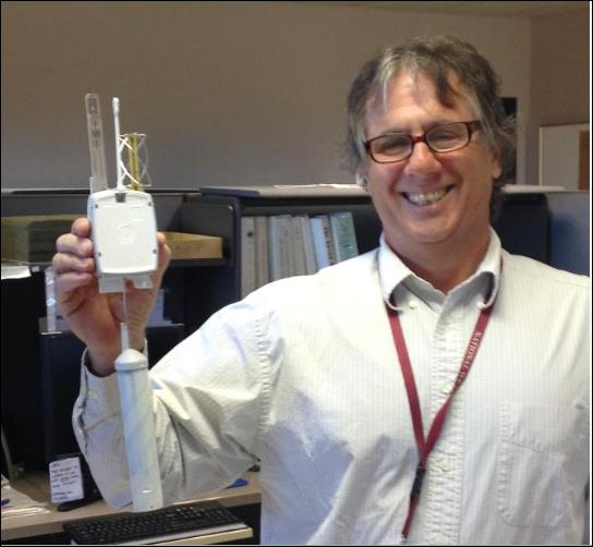
From the NWS El Paso Facebook page - Forecaster Joe Rogash holds one of the new Vaisala RS92 GPS sondes. The NWS is quietly, and gradually, replacing the unreliable Sippican Mark IIA sondes that were part of the original RRS hardware procurement.
Last July the Vaisala sondes went into operational use at Flagstaff, AZ, Caribou, ME, Springfield, MO, and Key West, FL.
At 00 UTC on March 1st, 2013, seven more NWS stations switched to the Vaisala sonde:
El Paso, TX, Morehead City, NC, Gaylord, MI, Medford, OR, San Juan, PR, Guam, and Barrow, AK.
On April 1st eight more stations will changes over to the Vaisala sonde - eventually the early procurement mistakes of RRS will be addressed at all NWS upper-air sounding sites.
An aside, Joe and I first met way back around 1980, when we were both graduate students at Colorado State University.
Sunday, March 03, 2013
Miscellany Sunday March 3rd
I have been away most of the day, and it has been a bit interesting this afternoon with mammatus, virga, and perhaps a few sprinkles around, as middle and upper cloudiness streamed in from the Pacific. See the 6 pm image from the campus webcam below. The surface observations on the NWS website for TUS have been bonkers for the last three days - e.g., it is showing a high yesterday of 105F for Tucson. If one goes to the daily climate area of the NWS page, it turns out high yesterday was 84F and high today was 81F. The low here yesterday was 33F so there was about a 51F diurnal range. Not bad for this time of year.
The long-range forecasts from the global models indicate some stormy weather likely across Arizona next Friday afternoon and Saturday. Above is operational ECMWF 500 mb forecast valid at 5 am MST next Saturday morning (9 March), and below is the same from the GFS. Both forecasts are quite similar over the Southwest. If these verify, a strong Pacific cold front will move across southern Arizona next Friday afternoon with showers from late Friday into Saturday. This will be our first storm event of March, and the NWS is already forecasting 60% chances for rain at the airport Friday night and Saturday. The ECMWF forecast is more progressive, with the next short wave already approaching western Canada - will be a few days before we have a good feel for how quickly the Southwest system will head toward the Plains.
Saturday, March 02, 2013
The Bryant Bannister Tree-Ring Building
The new building that now houses the University of Arizona Laboratory for Tree Ring Research was officially dedicated and opened yesterday afternoon. Today (Saturday March 2nd) the building will be open to the public from 10 am to 4 pm MST for those who want to see and tour the new facility. The building is just northeast of the Sixth Street parking garage, where parking will be free today.
The laboratory has been housed "temporarily" in the dark spaces under the west side of the football stadium. The lab was in these dank, dirty, leaky, and noisy spaces for only 75 years. So, this is a momentous occasion for all affiliated with the laboratory. Katie's new office is a tremendous breath of fresh air for her.
The building is named for a past Director of the Laboratory. It was made possible because of a donation of 9 million dollars from Agnese Haury, widow of the late Emil Haury. He was an archaeologist back when a new science, "dendrochronology", was developed by astronomer A.E. Douglass. Douglass wanted to correlate tree-ring growth to a long-running records of sunspots and climate. When Haury teamed with Douglass they were able to use tree rings to date the mysterious, abandoned ruins of the Anasazi and other ancient peoples of the Southwest. The laboratory continues today, using tree-ring data to study climate, weather, wild fires, water resources, and archaeology.
Thank you Agnese!
Friday, March 01, 2013
A Look At The Northern Pacific
The water vapor image from 1215 UTC this morning (above) shows three distinct, upper-level vorticity maxima. The corresponding 500 mb analysis (below) shows that the western-most short wave is currently the strongest wrt vorticity. The analysis also shows a weak, subtropical low in the southern flow stream (at about 140W and 20N).
By 96-hours (below, valid at 12 UTC 5 March 2013) the GFS forecasts several things wrt the evolution of the pattern. A huge cyclone evolves and drifts westward over Siberia as ridge over Alaska intensifies. The middle short wave dives under the amplifying ridge and approaches the West Coast. The easternmost short wave plows through the western US ridge and is over the middle Mississippi Valley. So little of significance over the Southwest over the next few days, except for a nice warm-up. There is a lot of high cloudiness with the southern-stream feature (see top image) and some of this may impact the Southwest.
Brief Summary For February 2013
Here at the house there was measurable precipitation on three days, The most important event occurred on February 20th when both rain and snow produced a total of 0.63". Total precipitation for the month was 0.85". This brings the total for 2013 to 1.61", which is a good start to the year. Last year the total at the end of February was only 0.37".
Was cold - see previous post also - with morning lows of 32F or colder occurring on 16 days. There were 3 days during the month with morning lows of 25F or colder. However, the temperature here did not drop to 20F or colder during February.
Thursday, February 28, 2013
Freezing Temperatures In Tucson This Season
The above graphic is from the NWS webpage this afternoon. The 23 days so far this season with lows of 32F or colder at the airport (TUS) is the second highest number for the past 25 years. As readers here know, the airport location is one of the warmer spots in the metro area. To contrast, here at the house (within the Tucson city limits and near the Rillito Wash) there have been 51 days so far this season with lows of 32F and colder. Quite a difference in number of freezes over a distance of about 11 miles.
Long-Range Look To The East
The 7 day forecasts from the operational versions of the ECMWF and the GFS have considerably different outcomes for the east coast. The ECMWF valid at 7 pm EST next Wednesday (above) forecasts a significant storm for Washington D.C. The same forecast from the GFS (below) forecasts a weaker storm, further south, that would impact the Carolina coasts. The politicians will likely be sequestered indoors, if the ECMWF is accurate. Will be interesting to see how this situation evolves.
Wednesday, February 27, 2013
Golden Sunsets
The last two days have brought golden sunsets under perfectly clear skies - above was on Monday evening. The mornings have been cold here at the house, with 6 days of freezing or below low temperatures. The last two mornings and this morning have had lows of 24F, 26F, and 27F today (Wednesday, February 27th).
Very little weather indicated by the global models for the Southwest through the next ten days. Above is GFS, operational version, forecast of total precipitation through March 3rd, and below is same through March 8th. Tucson Chamber of Commerce probably happy to see this after serious winter weather disrupted events last week, getting Tucson national attention and news photos of snow on the cacti at Dove Mountain.
Monday, February 25, 2013
Dual-Pol Product from Norman
The match-play golf tournament is now history: snow cancellation on Wednesday; snow delay on Thursday; and nasty winds and very cold wind chills on Sunday. The ECMWF operational model had an excellent forecast for the week, as highlighted in the post on Sunday the 17th. Will the PGA come back to Dove Mountain in 2014? My guess would be "not".
There is a nasty winter storm deepening over the southern Plains this morning. I just took a look at some of the Dual Polarization products from NWS radars in the storm area (note that you need to go to the CoD web page to do this - link to right). The above image is the Hydrometeor Classification product from Norman, Oklahoma, at 1338 UTC this morning. If my eyes aren't failing me, I think that I see every class of hydrometeor on the scale - except for Ground Clutter (GC). The large area of "BIological" targets south of Norman looks suspect however. Details re the Dual-Pol upgrade and products:
http://www.wdtb.noaa.gov/courses/dualpol/outreach/
There is a nasty winter storm deepening over the southern Plains this morning. I just took a look at some of the Dual Polarization products from NWS radars in the storm area (note that you need to go to the CoD web page to do this - link to right). The above image is the Hydrometeor Classification product from Norman, Oklahoma, at 1338 UTC this morning. If my eyes aren't failing me, I think that I see every class of hydrometeor on the scale - except for Ground Clutter (GC). The large area of "BIological" targets south of Norman looks suspect however. Details re the Dual-Pol upgrade and products:
http://www.wdtb.noaa.gov/courses/dualpol/outreach/
Sunday, February 24, 2013
Cold Wind Blowing Today
Strong cold front passage this morning has led to a raw and windy day here in southeast Arizona. Above view of the Catalinas at about 1:30 pm (Sunday, February 24th) shows that there's some dust blowing in the wind also.
Surface plot (above) for southeast Arizona from MesoWest shows that the gusty winds are widespread (red numbers are wind gusts in mph). This morning's forecast from Atmo's WRF-GFS (below valid at 2 pm MST) was again right on. Quite a change from yesterday's Chamber of Commerce type day!
Thursday, February 21, 2013
Final Snow Photos
Snow made it through Albuquerque and David Cristiani sent these photos from his place on the east side of the city.
Bit More On The Snow
After the snow at mid-day ended, there was a bit of sunshine and it melted away. Then there were rain showers, followed two more periods of snow here at the house. Snow right at dark didn't amount to much, but then there was a period of fairly heavy snow after 9 pm MST. This covered the ground again (but not the patio flagstone). Guesstimated snowfall here at house of 1/2 to 1 inch. There is still a bit of snow on the ground and the rain gauge is holding un-melted snow, so a final reading will await its melting. Atmo's WRF-GFS forecast model made a number of excellent forecasts - although final precipitation amounts were higher than forecast at low elevations. Rainfall across the metro Tucson portion of the ALERT network ranged from 0.12" to 0.63" - but there may be un-melted snow in some of those gauges also. The very cold air aloft manged to squeeze out a large percentage of the moisture that the system carried in with it. For the first time this winter, there was a complete TUS sounding when I wanted to calculate the thickness. At 00 UTC last evening the 500 mb temperature at TUS was -30C and the 1000-500 mb thickness was 5336m.
Out at the golf tournament, less than half the field had gotten off the first tee when play was suspended for the day. The paper says they hope to complete both the 1st and 2nd rounds today - but there still may be snow cover out there. This morning will also see Tucson's Rodeo Parade, which will be a damp and chilly event.
Michael Eckert provided a nice link showing the snow at Dove Mountain to folks on the MAP list - see
http://www.dailymail.co.uk/news/article-2282044/Snow-desert-Nearly-unprecedented-snowfall-halts-play-Arizona-golf-tournament-Midwest-braces-deadly-winter-storm.html
Ron Holle sent these photos from his yard in Oro Valley, taken about 5 pm yesterday. Looks like frozen orange juice out there. Bottom photo shows snow on ground here for the second time yesterday - taken about 9:15 pm.
Out at the golf tournament, less than half the field had gotten off the first tee when play was suspended for the day. The paper says they hope to complete both the 1st and 2nd rounds today - but there still may be snow cover out there. This morning will also see Tucson's Rodeo Parade, which will be a damp and chilly event.
Michael Eckert provided a nice link showing the snow at Dove Mountain to folks on the MAP list - see
http://www.dailymail.co.uk/news/article-2282044/Snow-desert-Nearly-unprecedented-snowfall-halts-play-Arizona-golf-tournament-Midwest-braces-deadly-winter-storm.html
Ron Holle sent these photos from his yard in Oro Valley, taken about 5 pm yesterday. Looks like frozen orange juice out there. Bottom photo shows snow on ground here for the second time yesterday - taken about 9:15 pm.
Wednesday, February 20, 2013
Snow At House
Snowed here at house from about 11:30 am MST until 12:30 pm. The WRF forecasts were just excellent, especially the soundings forecast for today in yesterday's runs. Total precipitation only 0.14" up to current time.
Subscribe to:
Posts (Atom)