Wednesday, October 09, 2013

A Political Aside


                       Header from Maureen Dowd's apocalyptic editorial of October 5th.

Quick Look AM 9 October 2013


The current short wave digging south toward southern California has not been able to advect subtropical moisture into it as of this morning. Above is CIMSS PW product at 9 UTC this morning and below is 12 UTC water vapor image - both indicate limited moisture for southern Arizona at this time.


The early run of the WRF-NAM at Atmo continues to forecast very strong south-southwesterly winds this afternoon (Wednesday, October 9th) for much of Arizona - above forecast of 10-m wind speeds is valid at 4 pm this afternoon. The model also forecasts a band of increased PW along the cold front tomorrow morning - the PW forecast below is valid at 9 am Thursday morning - note however that values stay quite low over southeast Arizona.


Finally, the model manages to forecast some rain at the ground out in central/western Pima County and the over the Catalinas. The forecast below is for total precipitation through 6 pm tomorrow evening - so much of southeast Arizona has winds and dust today and clouds and sprinkles as the front moves through tomorrow morning.


Tuesday, October 08, 2013

Windy Day Tomorrow


The early WRF forecasts from Atmo today (Tuesday, October 8th) continue to forecast primarily a strong wind event for southern Arizona as the next 500 mb closed low digs south into southern California. Shown above is the WRF NAM forecast of 10-m winds valid at 5 pm MST tomorrow afternoon. Below is the same forecast, on the 5.4 km grid, for the Southwest at 5 pm tomorrow. Strongest winds (> 40 kt) forecast over the southern California and Baja mountains.


Monday, October 07, 2013

Tropical Storm Narda


Tropical Storm Narda developed during the past day or so far southwest of the tip of Baja. The storm is forecast to move generally west-northwestward during the next several days, remaining far from land. Infrared image above shows the storm at 1930 UTC this afternoon and graphic below shows the current NHC forecast for the storm.


Strong Pacific Front Across Arizona Later This Week

First low temperatures - Yesterday was the first morning of the fall with a low temperature in the 30s here, with a min at house of 39F vs 50F at TUS. This morning, in contrast, lows held in the lower 40s at the house. But at the airport, TUS appears to have had a min temperature only in the low 60s - east-southeast winds prevailed at TUS during the night while things were calm here near the Rillito.


At 500 mb a closed low develops over southern California by 5 MST by Wednesday afternoon - above is 500 mb forecast from this morning's new NAM forecast valid at that time. By 5 pm on Thursday afternoon (below) the forecast low has opened up and moved rapidly east-northeastward. The associated vorticity maximum moves across northern Arizona, with strong winds likely ahead and behind the front. The current NAM forecast is quite dry for the southern half of Arizona.


However, several of the GFS ensemble members forecast subtropical moisture intruding into Arizona as the front moves through. The 5 am MST morphed PW product (below), from CIMSS at the University of Wisconsin, indicates the presence of two atmospheric rivers along and off the west coast, as well higher moisture over the southern third of the GoC. The evolution of these moisture sources will be important for the precipitation possibilities with this next weather system.


Sunday, October 06, 2013

Detailed Rainfall Plots For Several Sites


Mike Crimmins (Univ. of Arizona - Dept. of Soil, Water, & Environmental Science) has developed a very useful web site for examining rainfall at a number of sites in Arizona and New Mexico. This information is at:
                             http://cals.arizona.edu/climate/misc/monsoon/monsoon_summaries.html

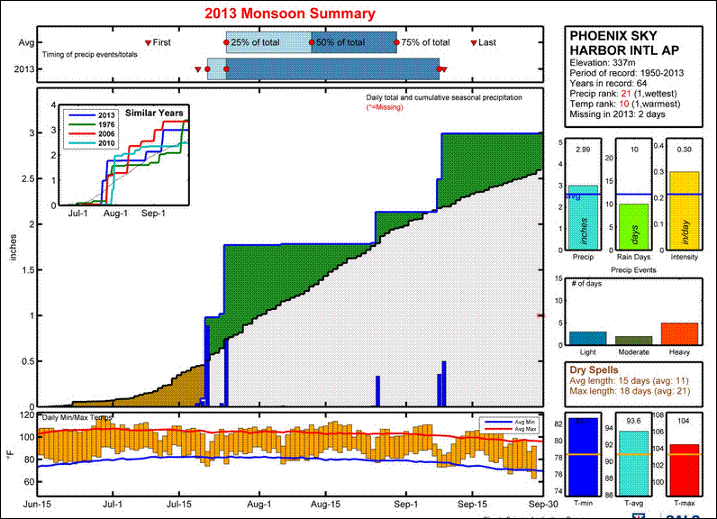
The perspective is Regional, but the data are presented in fine detail - as compared to say the fairly crude map presented in this morning's (Sunday, October 6th) Tucson newspaper. I've extracted the plots for summer 2013 at Phoenix, Tucson (above two), Douglas, and El Paso (two below).  These data are from the NWS observations at the airports in these cities. Phoenix ended up a bit above normal, while Tucson had a very down summer storm season (as I've been moaning about since the end of July). Douglas and El Paso were very wet this summer. But it is interesting that Douglas was extremely wet in July; whereas, El Paso picked up its heaviest rains during the second half of September during a significant transition event (this episode also produced devastating floods across portions of New Mexico and Colorado).    

At the url given above, Mike has provided a guide to the site and the data plots - enjoy.    


Saturday, October 05, 2013

Another Bobcat On The Circle


Our next door neighbor shot this photo of a large bobcat lounging on their patio yesterday afternoon. Outdoor pets beware.

Friday, October 04, 2013

Tornadoes This Evening


Large, wedge tornado (above) a bit over an hour ago near Wayne, Nebraska. Omaha base-scan radar from 6:10 pm CST (below), showing large supercell and hook echo east-northeast of Sioux City, Iowa.


Significant Storms Continue


Blizzard continues today in the Black Hills of South Dakota - above is from web cam at the Crazy Horse Memorial.

Santa Ana winds are blowing in southern California and statement just below is from the NWS Los Angeles office.

At bottom is visible image showing TS Karen in the Gulf of Mexico (center of storm circulation is just west of the deep convection - a bit west of 90 W). Karen will move ashore over the east-central Gulf Coast and bring some threat of heavy rains to much of the Southeast.


June Through September Rainfall


                             Early storms to the southeast, from here at the house - June 14, 2013.

Here are some rainfall reports for the past four months:

Holle (Oro Valley)                                  Jun  T   Jul  3.03  Aug  2.31  Sep  0.45  Total    5.79 inches

House (2979 E. Placita Santa Lucia)       Jun  T   Jul  0.83 Aug  0.68  Sep  1.04   Total    2.55 inches

Lyle (north of Broadway near                 Jun  .02  Jul  1.68  Aug  0.41  Sep  0.56  Total   2.67 inches
         El Con Mall)

Ertman (far southeast Tucson)             Jun  0.33  Jul  1.12   Aug  1.38  Sep  1.85  Total    4.68 inches

Santa Rita Abbey (NW of Sonoita)    Jun 0.30  Jul  5.28     Aug  2.63  Sep  2.22  Total   10.43 inches

Art Douglas (Ash Canyon)                 Jun  0.74  Jul 10.59   Aug 3.18   Sep  2.33   Total  16.84 inches

The totals here at the house for Jun - Aug and Jun - Sep are the driest during my 15-years of records here. The four-month rainfall was 2.91 inches in 2001 and 4.25 inches in 2009. So, a very dry summer season for the northern parts of the Tucson metro area.


                                        Santa Rita Mountains for the Abbey - August 10, 2013.

Thursday, October 03, 2013

Significant Storms - Elsewhere Of Course


Tropical Storm Karen has developed during past 24-hours and is now off the northeastern tip of Yucatan - above shows position this morning (Thursday, October 3rd). Below is the current forecast for Karen from NHC. The NHC forecasts Karen to briefly become a weak hurricane, before it goes ashore along the central GoM coast. Hurricane and Tropical Storm Watches have been issued. Weather attention the next several days will be mostly focused on Karen, especially given the forecast track.


Meanwhile, a cold, closed low at 500 mb is bringing snow to the northern Rocky Mountains this morning. The early WRF-GFS (at 5.4 km grid) forecasts the main snowfall from this storm to impact I-80 across southern Wyoming. The WRF-GFS forecast of accumulated snow through midnight Friday night is shown above.

Long dry spell continues here with breezy and slightly cooler conditions next couple of days.

Wednesday, October 02, 2013

Jon Talton Blog Re Yarnell Hill


Jon Talton (above) wrote an interesting blog entry on the day following the Yarnell hill tragedy. Jon is a journalist and also author of a number of mystery novels set primarily in Arizona. He is a native Arizonan. I am certain that he is not happy with the bland investigative report that has been released. The first two paras of his post are below - it can be read at:    http://www.roguecolumnist.com/rogue_columnist/2013/07/young-men-and-fire.html


Tuesday, October 01, 2013

Monday, September 30, 2013

Sunday, September 29, 2013

Yarnell Hill Wildfire Investigation


The investigation report concerning the tragic Yarnell Hill wildfire was released yesterday. Maps above are from the report. I have only scanned the report online this morning and will read through it more carefully later today. The reports in the morning papers indicate that Yarnell residents and others were upset at the formal briefing yesterday because the report did not determine exactly why the Hotshot crew was where it was when the fire overran them. At first read, it appears that radio communications were lost during the half-hour leading up to the tragedy and that the exact location of the crew was unknown. It is quite surprising to me that leaders of crews of this type don't carry a GPS. The entire report is at:


Saturday, September 28, 2013

Cool Fall Morning In Tucson


From Jack Hales webcam board - view of the Tetons in Wyoming this morning - September 28th.

Here at the house the low temperature this morning was 45 F - 10 degrees colder than the grid point forecast for here of 55 F. The airport recorded a low of 57 F.

Some lows this morning for RAWS stations:

Empire  (at 4650 ft MSL)  43 F - morning lows here at house are often very close to those recorded at                      Empire although there is about 2400 ft difference in elevation.
Mt. Hopkins (at 7120 ft MSL)    49 F
Rincon  (Rincon Mountains at 8290 ft MSL)  43 F
Sollers (Mt. Lemmon at 7800 ft MSL)    45 F  but
Columbine (Mt. Graham at 9521 ft MSL) came in at 28 F

So many of the high elevation RAWS sites were fairly warm. But between here and Sollers there is a foothills banana belt with warmer readings - for example Saguaro RAWS near Sabino Canyon had a low of 53 F.

Finally - if anyone wants to share their rainfall amounts for June through September please email to me at bob@squidinkbooks.com    -  Thanks

Friday, September 27, 2013

Pacific Front Moving Across Southeast Arizona This Morning


Pacific cold front moving across southern Arizona today with bands of heavy, low clouds. View of Catalinas above was at 7 am MST and visible satellite image below was from 8 am. There have been some very light showers in the mountains, with one station in the Catalinas reporting 0.04". Winds yesterday ahead of the front gusted from 40 to 60 mph over much of eastern and northern Arizona.


The 12 UTC morning sounding (above) at Tucson shows increased moisture in low-levels but CAPE is limited to a shallow layer below 650 mb, due to the very strong temperature inversion there. Thus, not much chance of showers except on the mountains. Looks like September will close out very dry for southern Arizona - there was only rainfall here at house on 4 days, with the last one of those days being the 9th.

Wednesday, September 25, 2013

Here Comes Another Blustery Short Wave


Another 500 mb short wave will be moving across the West tomorrow and tomorrow night. Moisture with this system stays far to the north but winds will kick up again across Arizona. Graphic above shows this morning's NAM forecast, at 500 mb, valid at 2 pm MST tomorrow afternoon (Thursday, 26 September). The early WRF-NAM forecast of 10-m winds on the 5.4 km grid, valid at the same time, is shown below. More cool mornings behind this system for the weekend. Lows the last three mornings here at house have been 54 to 56 F - very pleasant.


Monday, September 23, 2013

When It Rains It Pours - A Travelogue


Katie gave a talk in Albuquerque yesterday afternoon and our quick trip over there proved to be quite an outing. We used frequent flyer miles on Southwest Airlines (one of their fleet of 737s above) to book our trip. Unfortunately, Southwest had eliminated the several flights it had had between Tucson (TUS) and Albuquerque (ABQ) a month or so ago. I considered setting the trip up so that we'd drive to and from Phoenix, where there are many more direct options. But no.... So we were scheduled to fly from Tucson to Los Angeles (LAX) and then on to ABQ on Saturday morning and to return on Sunday afternoon with a flight to San Diego (SAN) and then on to TUS. The short version of this story is that we actually flew on none of these flights!

On Saturday morning the flight to LAX was delayed because of marine-layer fog and low visibility (why was LAX located right at the ocean?). The delay extended so long that we could no longer make our connection to ABQ, and Southwest folks rerouted us on a flight to Las Vegas (LAS) and then a connection to ABQ. This worked but got us in a couple of hours late. It was a very windy weekend across most of the Southwest and our landing was very rough at ABQ. There was a head wind component but also a fairly strong cross wind component and the pilot landed very "hot", but mostly fell out of the sky the last 100 feet or so.  Welcome to Albuquerque. Talk went well yesterday and then we headed for home. But now the short wave (see several previous posts) was approaching ABQ.


We were scheduled for a 6:25 pm MDT departure. But a line of thunderstorms had developed and was moving in from the south-southwest (above is 6 pm MDT radar from NCAR RAL) - the NWS ABQ radar is at the plus sign and is located about 20 miles west-northwest of the airport. These storms intensified and moved in rapidly - below is a not-very-good photo of their approach from the concourse at a bit after 6 pm MDT. The heavy rain with the storm, and frequent lightning, shut the airport down and the plane that was to head on to SAN from ABQ had to land at El Paso.


 It became clear that this plane would not make it up to ABQ and then on to SAN in time for our connection to the last SAN-TUS flight of the day. Southwest could book us on a flight to Phoenix (PHX), and we decided on this option, since Katie really needed to be back at the University this morning (they did also offer overnight accommodations and flights back this morning). A trailing line of thunderstorms developed (below is regional radar at 8 pm MDT) and these storms delayed the flight to PHX by about another 2 hours.

We did eventually get to PHX; rented a car: and arrived home after midnight. Very tired, but glad not to be in a hotel in ABQ. We started out the day today having to return the rental car and retrieve my car from the airport parking lot. So it goes.

I think this story illuminates what the future may hold for many of us, as the airlines reduce service and flights to mid-sized cities and completely eliminate flights to smaller cities. Not a pretty picture.


Over The Weekend

We've been away this weekend in Albuquerque and our trip was much impacted by the strong 500 mb short wave that was crossing the Southwest. More on this later. Rain gauge here dry and dusty this morning but wind blown debris in car port and on front porch. Low temperature this morning a cool 56 F here at the house. It looks like winds generally gusted yesterday from 30 to 55 mph across Arizona, with strongest gusts up in the northeast part of state.


Campus webcam view of the Catalinas (above) at 7 am this morning (Monday, 23 September 2013) shows some dust suspended in the air. View at 11 am MST yesterday captured heavy clouds and some showers moving through with the short wave.


The ALERT network this morning indicates 15 sites with rainfall during past 24-hours, and these were all in the Catalina Mountains and northern part of the network. The Catalina Mountains sector is shown below. There were two severe thunderstorm reports south of Albuquerque yesterday evening and one north of the Catalinas in Pinal County - all were thunderstorms with severe winds. More later, after I tackle nearly 100 emails that have accumulated, recover my car from Tucson airport parking lot, and .........