skip to main |
skip to sidebar
Jim Toth reports a heavy downpour early this morning at his place, a couple of miles northwest of here:
I had 2.1 inches as of 9 AM, most of it between
a-little-before-6 and a-little-after-7 AM. Word from
neighborhood emails about an hour ago is that Orange Grove Rd
was impassable due to flooding just west of 1st Ave (a mile
north of me).
Russ Scott sent a couple of links to USGS gauges on the San Pedro. Below is from the gauge at Palominas, just north of the international border. Note the river's rise of over 15 feet at this gauge.
Caught by showers moving in from northwest on my walk this morning and had to wait it out in the Natural Resources Park. View looking north from campus above is from 7 am MST. Morning rainbow (below) visible here at house at 7:15 am.
The morning sounding from TWC on campus (above) is quite unstable, even though 500 mb temperature is only -3 C. The CAPE results from the very high moisture content below 600 mb - the 850 mb dewpoint is a remarkable 18 C and PW remains well above an inch and a half. The early run of the WRF-NAM model at Atmo forecasts morning showers moving south across eastern Pima County, and that's obviously happening now. There is enough CAPE present that, given some sunshine later, we might have some thunderstorms around rather than only low-top tropical showers.
Not much to say except that Odile remnants stayed south, tracking eastward fairly near the international border. Media hype on the 6 pm news last evening was awful for the metro area, which had only light rains off and on for past 60-hours. Art Douglas (who measured over 4 inches of rain at his Ash Canyon location) sent along the radar-rainfall estimate above, which shows that heaviest rains moved eastward across northern Mexico. Rain estimates terribly chopped up by ground clutter blocking out much of the low-level, tropical echo cores.
Below are two sectors from the ALERT network - rain amounts are for the 60-hours ending at 6 am this morning - Tucson metro averaged around 1/4 of an inch (0.32" here at the house). The bottom shows the south sector of the ALERT network where the rain amount gradient is very sharp from Green Valley south toward Nogales. (Note that when the radar was sited, the sector that covers Nogales area was sacrificed so that Kitt Peak could be blocked by Mt. Fagan,)
The model forecasts were close, but some stayed locked in forecasting heavy rains over Tucson even at the very short-term. The NHC forecasts were erratic and not terribly accurate for much of Odile's life, and the final forecasts from NHC continued to forecast a depression crossing northeastward through central Pima County.
Jack Diebolt sent the radar cross-section above - from Patagonia east to Ft. Huachuca at mid-afternoon. Note the very tropical, warm cloud structure of the echoes, explaining why the radar-rainfall maps were so very ugly. The plot below shows that there were almost no lightning CG flashes during the very heavy rains across the Borderlands.
Wonder what will happen to all the sandbags people were frantically filling all day yesterday?
The above is composite radar from NWS Tucson radar at about 2:15 pm MST this afternoon. The organized rain areas associate with the remnants of Odile are moving across northern Mexico and the Arizona Borderlands at this time. Radar loops indicate that heaviest additional rains will stay east and south of Tucson metro area. Further, dry air in the upper troposphere (water vapor image below is from 2:00 pm) is pushing eastward across Pima County. So it appears that whatever additional rain we might get will be from any local convective storms that can develop. Here at house we have managed a total catch in the gauge of only 0.29". Heaviest rain amounts have fallen during last 24-hours over the Catalinas and Redington Pass with only light amounts over lower elevation portions of metro area - so it goes. Bottom three graphics are current amounts across three sectors of the ALERT network showing this, with one amount over 3 inches recorded in Redington Pass area.
So far Odile has not produced much in the way of heavy rainfall in eastern Pima County. This morning 87 of 92 ALERT stations had measured rainfall in past 24-hours, but only 6 sites in the Catalina Mountains and Redington Pass area had more than half an inch. I did find two stations in southeast Arizona with just over an inch so far - Sells and a new ob site called Pioneer Field (northwest of Sierra Vista). Here at the house the total for Odile event stands at 0.18".
Heaviest storms yesterday were out in the lower Colorado River Basin and also in the San Diego metro area - quite something. Many severe thunderstorm reports out there. Some heavy rains also occurring over in southwestern New Mexico.
There is considerable media frenzy going on with Jim C. of the Weather Channel setting up yesterday along the Rillito Wash trails, where I usually walk. I was half expecting to find Al Roker broadcasting from the Campbell St. bridge when I walked this morning, but he was a no show. I've seen people sandbagging residences - a first for me since I've been out here.
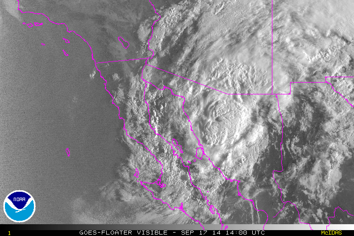
Odile is currently somewhere in the northern GoC, but with deepest cloud masses to east and northeast of the storm center. Visible satellite image above is from 7:00 am MST and does not show the center of the TS clearly. Below is the current NHC forecast for Odile and her remnant depression. This forecast brings the depression across central Pima County west of Tucson tonight, which would put us in the region of heavy rainfall.
Composite radar image from NWS TUS above is from 6:40 am and shows the first large rain band directly associated with Odile approaching metro Tucson from the south. This band is now moving across the metro area and it is raining lightly here at house. The radar shows nothing to its southwest where there should be lots of echo. This is because the precipitation echo tops are low, and there is a huge sector of terrain blockage to the lowest radar beams in that direction. Below (from College of DuPage weather page) is the lowest, 0.5 degree, base scan radar image. This shows clearly where the blockages are - the large one to the southwest is due to a small peak in the Empire Mountains just southwest of the radar and a designed blockage to the west by Mt. Fagan (at north end of Santa Ritas) that is meant to "protect" Kitt Peak from the lower radar beams.

I looked at the early WRF forecast runs. The NAM version is not reliable since it can't get Odile moving out of the GoC (I think that Mike Leuthold has been mentioning this in his discussions and updates). In contrast, this morning's early WRF-GFS moves Odile rapidly (faster than forecast by the NHC) northeastward right across eastern Pima County. Several intense rainbands accompany the circulation, producing very heavy rains in the model forecast. These basically are past the metro area early in the night and graphic below shows the very heavy rains forecast by that model through midnight tonight. Obviously this is a day for extreme caution and careful weather watch.
Tropical Storm Odile is partially over the warm waters of the GoC this morning and moving toward southeastern Arizona. While far to the south a new storm has formed - TS Polo. Above is morning overview from the NHC, while below is an IR image from 1230 UTC.
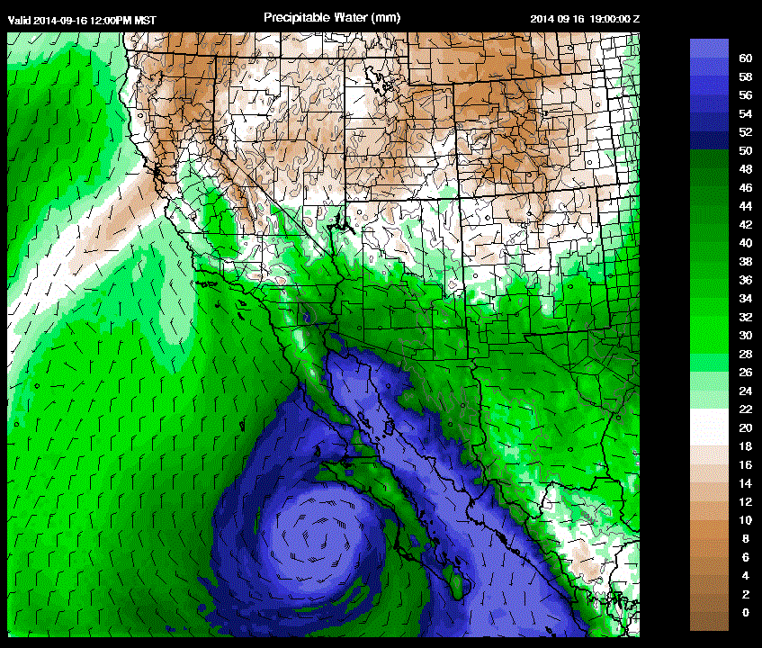
Some light showers moved across eastern Pima County durng the early morning hours (about 0.01" here) and there is currently a long band of light rain extending across the metro area and well to the east and west of Tucson (composite radar image above is from about 6 am MST). The high PW associated with Odile now covers the low elevation areas of southern Arizona with values of 1.75 to over 2:00 inches.
Mike Leuthold did special model runs and a discussion last evening highlighting the heavy rain and flood threats though the next couple of days - however, it does not seem to show up at the link to the right.
The models are all zeroing in on southeast Arizona as the remnants of Odile move directly notheastward across our area. The rainfall forecasts shown here emphasize the need for weather alertness and caution through Thursday. Amounts are valid for period ending at 5 am MST on Friday morning the 19th. Graphic above is from the NAM and below is from the GFS.
From Mike Crimmins - two summers at Phoenix from his webpage. Top is this summer which was very dry until Norbert event in September. Below is 1970 which was dry until Norma event in September - interesting in that it was the "N" tropical storm in both years that changed the character of the entire season.
Jack Hales sent along these observations from San Jose del Cabo that he grabbed from MesoWest before the power was lost down there a bit after midnight. This site is up the coast northeast of Cabo San Lucas (see map below). Winds gusting well over 100 mph and note the six-hour rainfall of over six inches in six-hours - although, the gauge catch can not be very accurate with such wind speeds.
Hurricane Odile has proven to be difficult to forecast and illustrates that much progress remains possible for hurricane forecasting. Shown here are 4 forecasts from NHC of Odile's anticipated track. Top is from 8 am on September 10th; just above is from 8 am on September 11th; just below is from 5 am yesterday morning; and bottom is from 5 am this morning - Monday September 15th. Note that the first forecast was extremely close to the path Odile has followed so far. The next two forecasts shown were off to the left of the actual track by varying distances.
Unfortunately, the storm moved fairly rapidly once it started moving and made nearly a direct hit to Cabo San Lucas during the early morning hours today. The situation was apparently chaotic yesterday in Cabo, as flights were cancelled and tourists were stranded. We hope that the town weathered the storm as well as possible. This morning the storm is moving up Baja, and current NHC forecasts indicate it will slip east again, ending its life in the northern GoC. It's exact path will determine to a large degree how the week plays out in southeastern Arizona.
High values of PW continue to extend north to the lower Colorado River Basin (above is MIMIC analysis for 12 UTC from University of Wisconsin CMSS). With pressures lower near the weakening storm, highest PW values will tend to track with the storm, making the situation quite different than was the case with Norbert.
The exact details of how things will play out can not be forecast very accurately at this time. The day-to-day evolution of the thunderstorm activity across southeastern Arizona will modulate the next day's activity and etc. I have shown below the early WRF-NAM forecast of rainfall on the 5.4 km grid for the period ending at 11 pm MST on the 17th (Wednesday). Through that time, the heaviest rains have spread northward with Odile, but are still confined mostly to Mexico in the model forecast.
There is a small herd of urban javelina that lives somewhere along the Rillito, or up a side wash, near the end of Country Club. In their nocturnal wanderings they have some times come up our circle and I have encountered them a number of times on my morning walks. They have paid two visits to our back yard during the past few weeks, coming in through a small break in the ocotilla fence back in the far corner of our lot. The first visit they made quite a mess, eating up all the plants that appealed to them, breaking a large pot, dumping the trash bin, and leaving muddy nose prints on the front porch, full-length windows. Their visit on Thursday night this past week was less damaging; however, neighbor John Ferner had set up a surveillance camera and caught several shots of them back where the break in our fence is. Above photo is apparently of a juvenile digging along the neighbor's side of the fence

The storms on Friday afternoon and evening avoided our rain gauge, but above photo is of a rainbow with a dissipating storm just to the east, with a more distant storm off to the southeast. We were at Santa Rita Abbey Friday evening and Saturday (about 5 or 6 miles northwest of Sonoita). The storms that were scattered around southeast Arizona and northern Mexico put on a nice show of fireworks after dark. A storm out there hit at a bit before 9 pm with strong winds from the east - could not see enough to even estimate how strong the gusts might been. Storm produced 0.33" of rain, and left behind enough low-level moisture for low clouds to hang on the Santa Rita mountains at sunrise Saturday. Photos below are looking west at the mountains just before and after sunrise. If you look close, the summit of Mt. Wrightson is sticking just above the clouds.
An unusually strong, early season cold front is pushing southward along the Front Range and into the Southern Plains. This front brought the first snow of the season to some locations in Wyoming and along the Colorado Front Range. The NAM analysis at 12 UTC for 850 mb (above) shows the strong temperature gradient along the front, which extends into northeastern New Mexico. Visible satellite imagery from 7:15 am MST (below) shows the extensive cloud mass along and behind the front. The 850 mb analysis also indicates that there is a tropical disturbance over the western GoM and that a band of strong easterly winds along the northern periphery of this disturbance reaches westward to the New Mexico Boot Heel. A broad and amorphous inverted trough stretches along the west coast from southern Mexico north to Washington state - certainly a very complex large-scale pattern.


Graphic above shows detected CG flashes for 12-hours ending at 7 am MST this morning. Of note is intense storm activity over the southern GoC; widespread thunderstorms with the GoM disturbance; and thunderstorms along the Plains cold front. The early run of the WRF-NAM at Atmo continues to forecast an extended period of strong easterly winds in southeast Arizona, as the Plains cold front backdoors westward across the Continental Divide. The WRF forecast of 10-m winds below is valid at 9 pm this evening.
The NAM model from this morning forecasts the frontal zone to be nearly to the Colorado River by tomorrow morning (above); and the WRF-NAM forecasts strong winds to continue through the day tomorrow and to affect all of southern Arizona. The WRF also forecasts isolated thunderstorms for parts of Pima County today, with more extensive coverage across Cochise County - forecast below is for total precipitation through 5 am MST tomorrow morning.
To the south, Tropical Storm Odile has remained nearly stationary during the past 24-hours. The NHC forecast for Odile, once she decides to begin moving northward, is similar to yesterday's forecast. So, many interesting weather features over and near Arizona for the coming few days.




.jpg)