
Thunderstorms developed nearly overhead around 8:30 pm MST last evening and lasted until around 10:00 pm. Considerable lightning and thunder here with moderate showers - total rain at house was 0.35", while several ALERT gauges just to the east had amounts approaching an inch. A strong outflow from the south moved into Tucson around 4:00 to 5:00 pm yesterday afternoon - produced by a cluster of strong storms over the Santa Rita Mountains that had then drifted westward. The outflow appeared to stall over northern portions of the city, e.g., it's passage here wasn't very noticible. Winds at Casa Grande remained west to west-northwest until after 9 pm. The RAWS station at Saguaro had a slight shift to south winds, but then returned to west to northwest winds by 7:00 pm, followed by an outflow from the east around 8:00 pm. The airport, Atmo, and DM also had an outflow from the southeast to east as the storms were developing. Radar image above shows the storm echoes at 8:44 pm. We first heard thunder here a bit after 8:30 pm.
------------------------------------------------------------------
Bottom line is that substantial mesoscale convergence occurred over central Tucson around dark, triggering the storms. At 7:00 pm last evening only 10 of 93 ALERT stations had had rainfall. However, this morning 54 sites report rainfall, with 7 sites having more than 1/2" an inch. The ALERT gauges in Greater Tucson had rain at 19 of 20 gauges! So, a nice late event, driven by local convergence resulting from earlier, higher elevation storms.

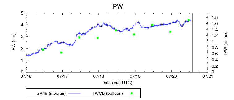
The evening Tucson sounding had a BL reaching to just above 700 mb, but with only the slightest sliver of Tv CAPE (see SPC analysis top above). However, in comparison to GPS PW data, the sounding was at least 2/10 of an inch too dry - thus, there was actually more CAPE present than indicated by the RRS sounding data. Yet another example of how the bad RRS soundings can adversley affect short-term forecasts.
No comments:
Post a Comment