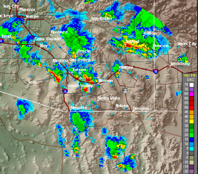
We have been away to Santa Rita Abbey - left here about 5:30 pm Friday and returned late Saturday - so I'm not sure exactly what happened here at the house. There had been the slightest bit of a Trace of rain here before we left and on our return there was a definite Trace in the gauge - so not really a precipitation event right here. However, there had been a power surge, or brief power outage, so there was lightning nearby and we probably had a thunderstorm here.
Above is the 5:00 pm composite radar image from NWS TUS on Friday. The storm crossing I-10 just east of the airport location was a hail-producer. When we drove through this bit of interstate at about 6:00 pm MST there was hail drifted along the shoulders of the highway and the desert was white with melting hail - no idea how large it might have been. On Highway 83 there was a thunderstorm over the Empire Mountains and we drove through a brief period of heavy rain.
The CG flash density plot below (from weather.graphics and Vaisala) is for the 48-hour period ending at 6:30 am MST this Sunday morning. There was definitely quite a bit of lightning and thunder over eastern Pima County - indeed more coverage by lightning than by measurable rainfall. For the 24-hour period ending 6:00 am on Saturday morning 36 ALERT sites (~40% areal coverage) measured 0.04" or more rainfall. There were 7 sites with more 1/2 an inch and 1 site in the Catalinas with more than 1 inch. Yesterday the activity was down quite a bit with only 19 sites having rainfall (~20% coverage) with the maximum amount reaching only 0.24" at two sites.
The WRF runs early Friday considerably over-forecast the coverage and intensity or the afternoon storms for Friday. However, I did notice that the ASOS site at Casa Grande had reduced visibility in blowing dust during a severe thunderstorm yesterday that produced gusts to 61 mph at the station The biggest day of the past three occurred with the very heavy storms in Cochise County and the Borderlands Thursday afternoon and night, and our unusual June event went downhill from there.
The bottom panel shows the GEFS average 500 mb forecast for next Saturday at 5:00 pm MST - quite a summer-time anticyclone for a very large part of the continental U.S. LOOKS HOT FOR LOTS OF FOLKS.
Sunday, June 12, 2016
Subscribe to:
Post Comments (Atom)


No comments:
Post a Comment