Friday, October 29, 2021

Very Dry


Pre-sunrise views early this morning - above along I-10 at San Simon and at bottom a view of downtown Phoenix looking east.

Above is total precipitable water (TPW) from the 06 UTC WRF-GFS at midnight last night. The MIMIC analysis for TWP at 13 UTC (below) shows that most of the western half of North America is very dry.

Second below are the plumes for TPW at the airport from 06 UTC GEFS - extremely dry through the period (TPW at airport this morning is only 9 mm), with values for all members staying less than 15 mm through the first week of November. Little to look forward to as we move into the last month of meteorological Fall.


Tuesday, October 26, 2021

Morning Sprinkles Here


Heavy clouds over the metro this morning a bit before 8:00 am MST, as cold front moved through. Down at bottom is view of some nice Fall color up in Prescott.

 but wStrong, but moisture-starved trough at 500 mb was west of Tucson this morning (analysis above from SPC) - note the very strong winds with this trough. The 12 UTC morning sounding from TWC/TUS (below - also from SPC) shows the strong, vertical wind profile, with only a shallow layer of saturated air near 700 mb.


Forecast above is from the WRF-GFS run at 06 UTC and is for total precipitation through 5:00 pm this afternoon. Here at house we had very slight sprinkles before the front passed - so a very minimal Trace.

The 06 UTC GEFS plumes for temperature at the airport are shown below - cool today and tomorrow, but then back up into the 80s. October is closing out as a very dry and mild month.


Saturday, October 23, 2021

October Winding Down


October has been very quiet, but there's a bit of Southwestern US weather to write about as the last week of the month begins. 

There was some color just around sunrise this morning: above view from campus and at bottom the view east along I-10 from Wilcox.

Forecast above from 06 UTC GFS is for 500 mb valid at 12 UTC on Tuesday morning (October 26th).  A sharp 500 mb trough is located near Tucson as it moves to the east, Conditions are very dry with this system, and its main impact will be to bring a couple of chilly mornings here in Tucson metro area. Two forecasts below are from the 06 UTC GEFS model runs. Chances for very light sprinkle/showers are indicated on Tuesday morning (below), and temperatures (second below) are forecast to be much cooler on Tuesday and Wednesday, before a rapid rebound.


Finally, there is a new, named tropical system over the Eastern Pacific. Tropical Storm Rick was named yesterday afternoon and was upgraded by NHC to Hurricane Rick this morning. Rick is forecast to move northward into western Mexico, and to intensify into a moderate to strong hurricane before making landfall. Above is a visible image of Rick from 1550 UTC this morning, and below is current forecast track from NHC.


Wednesday, October 13, 2021

Late Post

Still some haze and dust in the air but not nearly as bad as yesterday.


Snow in the High Plains last night, continuing this morning. Above is Devil's Tower, Wyoming, shrouded in snow, and below shows the abandoned main street of Deadwood, South Dakota.


Below, from 06 UTC GEFS, are plumes for QPF at the airport for the coming week. Zilch.


Tuesday, October 12, 2021

Unsettled Morning


Heavy clouds coming off the Catalinas over the west side of the metro area this morning. Low-level dust is from the storm west of I-10 yesterday afternoon. There were a few sprinkles here around 7:00 am, and perhaps enough to wet ground to our west.

Strong winds after midnight this early morning brought gusts to 67 mph at Ft. Huachuca and 59 mph at Pioneer Airfield. Gusts of 30 to 40 mph were common over southeast Arizona.


Morning 500 mb analysis (above) shows intense, 500 mb closed- low over southwestern Utah, with very strong winds to its west, south, and east. This system is forecast to elect very rapidly to the northeast, reaching Colorado by evening - bringing winter storm conditions across the higher elevations and also Wyoming. Surface map (below) from about 7:30 am MST shows heavy snow currently impacting parts of Utah. Cold fron is moving into western New Mexico and Colorado.

Images at bottom show a skiff of snow on the ground at Flagstaff this morning and heavy rains in Globe before sunrise. All-in-all quite a wintry change from the past week!

Thursday, October 07, 2021

Colorful Sunrise

Three views of our colorful sunrise this morning. 

Above from here at house; below - from campus; and second below from Wilcox. Time for all about 6:20 am MST.


As for weather - the GFS forecasts indicate a long dry period ahead. Forecast below from 06 UTC GFS is for precipitation through 06 UTC on October 22nd.


Wednesday, October 06, 2021

Showers East Side Yesterday


Lingering cumulus on the Catalinas this morning. Bottom shows Fall color along the South Fork of the Snake River in Wyoming (from Jack Hales webcam wall).

Thunderstorms and light showers occurred over the east side of metro area yesterday afternoon - ALERT plot above for 24 hours ending at 8:00 am MST this morning - plot below of detected CG flashes (from Atmo and Vaisla) is for 24 hours ending at 0833 UTC early today. 

Rain amounts were generally quite light, but one site east of downtown reported 0.24". There was no no rain here, and if there were thunder, I didn't hear it. Composite radar (second below) is from 4:09 pm.

Models are forecasting no precipitation for most of Arizona during at least the next 10 days.


At 500 mb the cyclone over the lower Mississippi Valley developed yesterday and is forecast to begin lifting northward today. 


Tuesday, October 05, 2021

Still Slight Chance Showers


Early morning view of Catalinas at a bit after 6:00 am MST this morning.

Plot of detected CG flashes (above from Atmo and Vaisala) for 24 hours ending at 6:00 am (1300 UTC) this morning. Most thunderstorm activity stayed to the northwest of the metro area. Plot of ALERT reports for 24 hours ending at 9:00 am this morning (below) shows 15 sites had 0.04", or bit more, around the edges of the network - nothing here at house.


Visible image above shows shows considerable clouds and storms over Arizona, and Utah, as well as southern Nevada and California. Extreme southern Nevada did have storm activity during the late valid period of the outlook shown in previous post (see CG plot above).

Morning 500 mb plot (above from Univ. of Wyoming) shows the low heading into southern California and trough to its southeast, which will cross Arizona today.

Forecast sounding (from the 12 UTC WRF-RR) shows that at 4:00 pm there is still considerable CAPE as well as deeply mixed BL - so I would still expect some thunderstorm activity around our area. But precipitation forecast from same run (below - valid through midnight tonight) keeps most of the rainfall over the northern two thirds of Arizona.

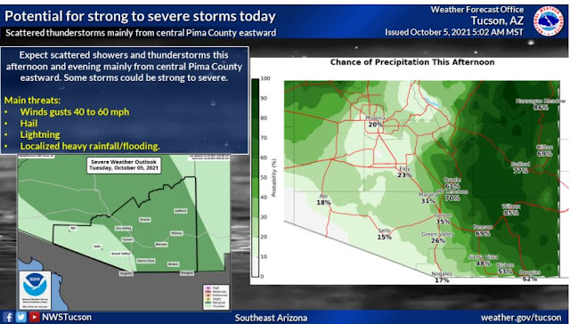
Morning outlook from Tucson NWS forecast office is at bottom.


Monday, October 04, 2021

Storms Possible

North view from Kitt Peak this morning shows a line of mid-level build-ups, as moisture begins to return.


The 500 mb closed-low remains well west of northern Baja at 12 UTC (above). Models continue to forecast the system to be ejected northeastward, bringing an open trough across Arizona tomorrow. Note - comments on this NWS 500 mb analysis: the observation plotted for Guaymas is clearly bad but got thru whatever quality control there is for plots, but was not used in analysis; cyclone center over Great Basin placed very badly; and height contour over Mexico/GoM is a mess.

Current NWS forecast for probability of measurable rainfall 
(above - 0.01" or more) indicates increasing chances this afternoon through tomorrow.


I took a look at the 09 UTC WRF-RR forecasts. Forecast of radar echoes (above) is valid at 9:00 pm MST this evening. Forecast of total precipitation through 6:00 am tomorrow morning is below - very light showers indicated for Tucson metro area. Second below shows same run's forecast of total rainfall through midnight on the 6th. The WRF forecast keeps tomorrow's more significant rain well north to northeast of our area.
I took a look at the forecast soundings for Tucson in the model run and they look like they'd support storms tomorrow - apparently the forecast brings subsidence behind the short wave into play before it can develop storms. I would go with the sounding forecasts and expect storms in the area tomorrow - will watch to see what actually happens.


Took a look at he SPC outlook for thunderstorm areas today (green shaded areas right of bold line), and it appears that Las Vegas office did not want to be included in the area over the Southwest - will watch this also.