skip to main |
skip to sidebar
Pleasant early morning today with cool temperatures and a nice sunrise highlighting some cirrus. Down at very bottom is Finger Rock just catching some sunlight and apparently a large hawk winging along on a morning hunt.
As for next week, the NHC morning outlook (above) continues to forecast that development of a new disturbance is likely, and that it will head generally northwestward toward the west of Baja.
A forecast of 850 mb winds and dewpoint temperatures valid at midnight on 20 September, from the 00 UTC WRF-GFS run at Atmo, is shown below. The model forecasts the tropical disturbance to be just about where the NHC outlook would indicate. What could be TS Paine has by the valid time of the forecast caused moisture to surge northward up the GoC and Colorado River Basin into parts of Nevada, California, and Arizona. Of course this remains five days away and so the details are very much uncertain. The forecast that is second below is from same forecast run and valid at same time as the 850 mb forecast, but is for total accumulated precipitation. At this long range the model forecasts Tucson to be sitting in the middle of a precipitation donut hole - so it will be interesting to evaluate this forecast next Wednesday morning.
Perfectly clear skies to our north at 7:00 am MST this morning. The plot below shows CG flash density for all of central and west U.S. for 24-hours ending at 7:00 am (from weather.graphics and Vaisala. There was a thunderstorm in southeast Arizona well north of the Catalinas yesterday afternoon. A tiny, orphan shower passed overhead here and produced a Trace of rain.
The 00 UTC run of the WRF-GFS goes out to a week and I took a look at its radar forecast. First storms in Pima County forecast by next Monday afternoon (above valid at 3:00 pm on the 19th). The return of higher PW seems mostly to advect in from the east. although by that time there may be a tropical disturbance in play also. This morning's outlook from the NHC (below) indicates a high likelihood of a tropical system approaching Baja by next Tuesday. Cool and dry mornings today and next several days will be much appreciated.
View at 3:00 pm MST yesterday from campus showed thunderstorms, some had hail reported, occurring again on north side of Catalinas. The plot of detected CG flashes through midnight last night (below from Atmo and Vaisala) indicates a bit more storm activity around the eastern edges of Pima County than I expected, and the WRF forecasts for yesterday afternoon were quite good.
Only 19 sites with rainfall across the ALERT network yesterday, with most of these in the Catalinas - no reports of rainfall of half an inch or more.
Little else to report as the advance of the western US 500 mb trough brings a general dry-out for the Southwest into the weekend. Forecast of PW below is from 06 UTC WRF-GFS model on the 5.4 km grid. Dark browns indicate PW values of less than 10 mm - current values across much of southern Arizona have fallen below 25 mm.
The NHC does expect another tropical disturbance toward the weekend to develop and move again toward the south end of Baja, which could perhaps affect southern Arizona sometime next week.
V
ery active thunderstorm day yesterday for eastern Pima County and much of the metro area. Mike Leuthold sent photo above of severe thunderstorm over the Catalinas late in the day. There were several reports of severe hail (see photo at bottom) and wind damage in the Oracle area on north side of the mountain. The plot of detected CG flashes below (from Atmo and Vaisala for 24-hours ending at midnight last night) shows the band of activity from Cochise across parts of Pima and into Pinal Counties. Here at the house we had thunderstorms twice during afternoon, with some gusty north winds to about 30 mph; little rain however, with total for both only coming to 0.20". Across the ALERT network more than 80% of sites had rain, but only nine of them reported more than half an inch, with none reaching an inch.


Very difficult forecast for today. The above forecast of composite radar echoes, valid at 4:00 pm MST this afternoon, is from the 06 UTC WRF-GFS model run at Atmo last night. It indicates a chance for storms around the edges of eastern Pima County, mostly over and north of the Catalinas.
The observed 12 UTC TWC soudning plot is a mixed bag. The SPC sounding analysis indicates considerable CAPE again today, but it is based on lifting the lower, moist layer that reaches only to about 800 mb. However, there is an elevated mixed layer above to about 550 mb. This amounts to a fairly formidable cap, not to mention the second potential cap produced by warm air above 500 mb. On the other hand, the veering, strong wind profile is typical of Plains severe thunderstorm environments.
Thus, if deep convection can overcome the capping layers, there is an excellent chance for severe thunderstorms. Looking at the forecast soundings from the WRF, I feel that they are not as favorable for storms as model seems to indicate. Based on my early look, I think storms are most likely from eastern Pinal and Maricopa Counties on up into the Rim Country. Will definitely want to take a look at the 12 UTC WRF forecasts.
Note - am having PC problems this morning and will post what I can quickly.
In what I think is a first this morning, the NWS has used a forecast from Mike Leuthold's local version of the WRF-NAM in its weather story - above.
The morning sounding for TWC (below from SPC) is moderately unstable this mornin, and an increase in PW would make conditions even more unstable with substantial CAPE. However, winds are westerly through the troposphere and the strong vertical shear of this transition pattern will spread anvils ahead of storms. A situation unfavorable for storms here at house, unless they develop nearby. The potential exists for strong to severe storms in some locations today and also for hail.
I show here two forecasts of PW from the 06 UTC run of the WRF-GFS at Atmo. Above is valid at 11:00 pm last night and below is valid at 11:00 am this morning - model forecasts an increase of almost 10 mm at TWC, which leads to widespread storms in forecasts for eastern Pima County. Forecast of WRF-GFS composite radar echoes at bottom is valid at 5:00 pm MST this afternoon.
We have been away at Santa Rita Abbey since Friday afternoon - so a bit of catch-up here. Photo above is looking south from the Abbey a bit before 4:00 pm MST yesterday. Showers were bubbling up and down, and some produced bits of anvil and some light rain. The 24-hour flash density map (below from weather.graphics and Vaisala for 24-hours ending at 7:00 am this morning) indicates no CG flashes with this storm, and I saw none.
Regarding runoff for the Newton rains - I've added a new stream flow plot from the USGS gauge at the Rillito and Dodge, second below. The second pulse of runoff on Thursday, while not very large, did produce flow downstream from the gauge and past the Campbell Ave. bridge. The second pulse was probably from higher elevations and from greater distances - still little runoff from a fairly significant, widespread precipitation event.
We remain in the persistent pattern of a weak 500 mb trough affecting the Southwest - above analysis is from NCAR RAP/RAL for 12 UTC this morning.Of interest are the cooler temperatures in the trough beginning just out west of here.
The morning sounding plot for TWC (from SPC - below) indicates CAPE values of possibly 500 to 1000 J/Kg later today - if moisture remains at current levels. However, the 06 UTC runs at Atmo of the WRF model forecast PW and CAPE to decrease by early afternoon (forecast skewT at bottom is from the WRF-NAM and is valid at 3:00 pm) and both models fore today's storms to stay east and south of the metro area's lower elevations. The morning sounding has PW of 32 mm but the WRF forecast sounding below has only 23 mm and no CAPE. With colder air possible at mid-levels, perhaps we'll we'll see something a bit between conditions this morning vs the WRF forecasts?
Another nice sunrise today, with a bit of jet contrail heading toward LA probably. The west coast trough dominates for the next week - below is GEFS 500 mb mean heights for 5:00 pm MST on Tuesday.
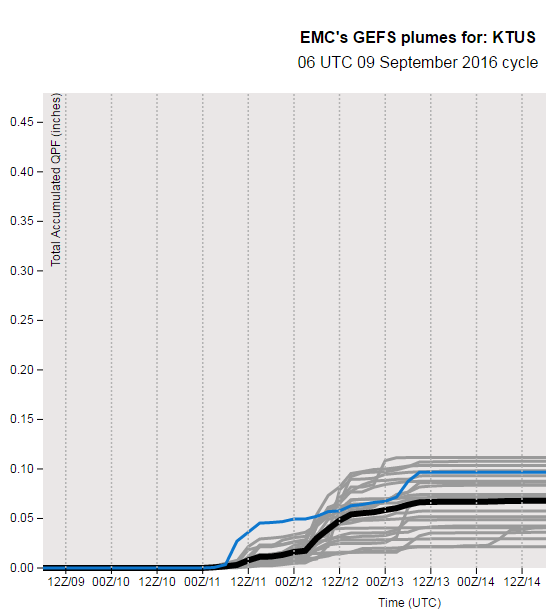
The main forecast questions relate to moisture and CAPE for southeastern Arizona - how long can low-level moisture linger and how will CAPE evolve, before dry Pacific air dominates during the week? The 12 UTC CIRA blended PW analysis (above) shows PW holding around an inch or a bit more (greens) across southern Arizona. The 06 UTC GEFS plumes for QPF at TUS (below) develop a spike of CAPE on Sunday that leads to a chance of thunderstorms in the metro area that evening. The 06 UTC WRF-GFS forecast of composite radar echoes at bottom is valid at 4:00 pm on Sunday. Some hope then for seeing thunderstorms around eastern Pima County before the new week begins.
The Newton event is now more-or--less history, although the remnant 500 mb circulation remains just off to northeast of Tucson and PW remains high. The swath of heaviest rains (see analysis map now posted at the NWS website) evolved somewhat similar to the Odile event. Model forecasts tended to keep heavy rain core too far west and north versus observations.However, moderate rains were more widespread to the north and west of the heavy rain area than was the case for Odile. View of Catalinas at 7:00 AM MST this morning (above) shows a bit of blue peeking through.

Rainfall data above are from ALERT network and are for 3-days ending at 7:00 am this morning. Unfortunately, the time resolutions are a bit lacking in the new soft. Our Newton event lasted more than 24-hours, but next period available is three days. Note that several amounts exceeded 6 inches, as did the RAWS site in the Rincons. Amounts were generally over an inch, except for parts of the core metro area - here at house the total was 0.83". Lowest totals were along I-10 and appear a bit suspect wrt nearby amounts.
The highlight scheme for amounts in the new ALERT software could use some fine-tuning also - currently amounts over one inch are shown no differently than amounts over six inches.
Couple of bits of data from RAWS sites shown here. At a bit after 7:00 pm last evening the Carr site on east side of Huachucas had measured over 5 inches - I suspect their final total was over six inches.
Below are some observations I snipped for Mt. Hopkins, where winds were gusting from the east at well over 60 mph yesterday morning.
The event mostly provided beneficial rains for low elevations, where conditions had been very dry since mid-August. Was surprised this morning to see that, given the heavy mountain rains, that there had been no flow in the Rillito downstream from the Dodge gauge, which never reached a 100 cfs. Long duration of event allowed ground to really soak up the rainfall.
View of Catalinas, through light rain, at 7:33 am MST. Below are base scan (0.6 degrees) radar echoes at 7:00 am from NWS TUS radar (KEMX).
Radar cross-section at same time, showing that heavier echoes are mostly below 10 kft (that is above the radar, so mostly below 15 kft MSL). Warm rain processes dominating, as would be expected, and echo tops below are quite low this side of border.
The radar estimated rainfall shown below for the event so far from the KEMX radar. This product illustrates well the problems, especially during a warm-rain event, with estimates from a single radar for southeast Arizona.
Newton is still at tropical storm strength and moving north toward the border. Morning position at 4:00 am MST above from NHC. Latest track forecast from NHC below.
It is very interesting that Newton is approaching the US within the huge swath of radar blockage (no data at low elevations due to terrain blocking the radar) that extends southwest from KEMX radar. Above is from NCAR and shows regional radar echoes for the base scan a bit before 5:00 am MST this morning.
Rainfall has, so far, been generally light across our area through 6:00 am this morning - below - there are a few amounts of a half to one inch, generally along the southern part of the ALERT network.