Monday, October 23, 2023

Showers Likely Tomorrow


Have been away this morning, but here's a quick update. View above is looking toward Redington Pass at 6:15 am MST this morning.

A significant, 500 mb short wave is digging into Arizona and northwestern Mexico. The forecast above (from the 12 UTC GFS) is valid at 18 UTC tomorrow and indicates strongest vorticity-advection occurs to our southeast,

The 06 UTC GEFS plumes for QPF at the airport (above) show that all members of the ensemble are forecasting some showers for tomorrow - although amounts are fairly light.

The WRF-RR run from 12 UTC this morning forecasts a nice event for the metro area (below forecast valid for period ending at midnight tomorrow night). Fingers crossed.

Sunday, October 22, 2023

Chance For Showers This Week


View of Catalinas at 6:10 am MST this morning, again showing cloudless skies.

Plumes from the 00 UTC GEFS for the airport.  Above shows for QPF, which indicates good chances for showers late Monday and Tuesday. There has been no rainfall here at house for about a month now.
The plumes also indicate much cooler temperatures Tuesday and Wednesday (above), with PW (below) peaking on the 23rd and then decreasing slowly for rest of week to very low values next weekend. Hopefully there will be a bit of local weather to watch next several days!

Current morning forecast (above) from NWS for the airport and 00 UTC WRF-GFS forecast for rainfall through 6:00 am MST on Friday the 27th (below). Note that Tucson metro is on the very western edge of precipitation area.

Friday, October 20, 2023

Summer-Like Heat Continues


View toward the Rincons before sunrise this morning, showing nearly cloudless skies. Even though it is late October, temperatures remain summer-like over southeast Arizona. The high temperature at the airport yesterday reached 100 F, breaking the old record from 1921 of 99 F. High today could also hit record levels (record currently 97 F in 2003).

Most interesting weather is far to the south, as Hurricane Norma moves slowly northward toward southern Baja (IR image from 1520 UTC this morning shown above). Norma briefly reached Category 4 strength yesterday afternoon (sustained winds reached 115 kt). Current morning outlook for Norma's track (below from NHC) indicates storm brushing southern Baja and going ashore in central Mexico.


Question for early next week is whether or not moisture moving northward as Norma advances will make it into southeastern Arizona, The WRF-GFS forecast for PW from 00 UTC - below - is valid at 5:00 pm MST on Monday the 23rd. That forecast is keeping the higher moisture to our south. This will be main thing to watch during the coming weekend.

Tuesday, October 17, 2023

Showers Around This Morning


View toward the Rincons at 6:15 am MST this morning.

The morning upper-air sounding from TWC/TUS (above) shows a very deep, well-mixed, residual boundary layer (BL) that has a small amount of CAPE above 600 mb. The radar image from 9:15 am (below) shows a small area of storm echoes generally along I-19 toward Nogales - note that these data are from the 4rth tilt (3.1 degrees) because of the large area of terrain blockage that occurs southwest of the radar. Second below shows detected CG flashes (from Atmo and Vaisala) through 1613 UTC.


Forecast above is from the 12 UTC WRF-HRRR and shows rainfall through 6:pm this evening - all the rainfall in our area is over by this time in the WRF forecasts. Current POPs from the NWS (below) are valid through midnight tonight.

Monday, October 16, 2023

Waiting For Fall


View of the Catalinas at 8:15 am MST today shows another morning with cloudless skies.

Analysis of TPW (above - from 15 UTC) shows very dry conditions across almost all of the continental US. While the 12 UTC morning sounding from TWC/TUS (below) shows low PW, no CAPE, and quite variable winds aloft.


Somehow the WRF model runs forecast an increase in PW during the day today, with light showers at, or near, the airport. Forecast above is from the 00 UTC WRF-GFS and is valid through 5>00 am on October 23rd. Very warm forecast for next five days from the NWS this morning (below) indicates that slight chance for the airport tomorrow. Looks like we've still got some waiting to do before "Fall" makes an appearance!


Wednesday, October 11, 2023

Summer Summary


Heavy storm over the eastern Catalinas on afternoon of July 30th (above). A CG flash to the western Catalinas at 1:00 am MST on July 30th (bottom).

Precipitation amounts during summer 2023 here at the house: June  0.00"; July 1.73"; August 0.53". Total June through August 2.26" - this was the second driest summer total since I started keeping records in 1999. Driest year was 2013 with 1.51" (wettest year was 2021 with 10.98").

Adding in September gives a total of 2.57" (second driest for this period) this year. Driest for this period was 2020 with 2.28" and previous wettest was 12.47" in 2021.

I noted thunderstorms here on 11 days during July and August (there may have been a few others, but I did not hear the thunder). There was a severe thunderstorm here on July 17th, with estimated gusts 60 to 65 mph, which produced some significant tree damage on our circle.

For contrast and comparison, the two charts below show rainfall across the ALERT network for June through September.


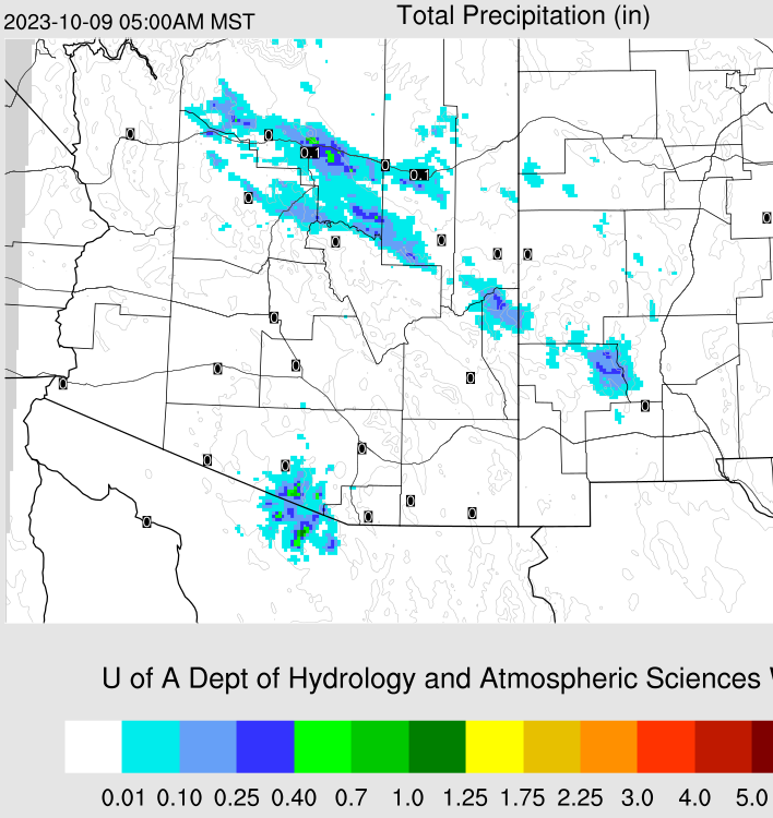
Monday, October 09, 2023

Dry Conditions Persist

Nice, pre-sunrise color looking toward Redington pass about 6:30 am MST this morning.


This morning's TWC/TUS upper-air sounding (above) has light winds below 500 mb and perhaps a sliver of well-mixed, afternoon BL CAPE around 500 mb.
Plumes from the 06 UTC GEFS runs indicate gusty winds likely on Wednesday (above).  The trend for PW this week is forecast to start out around 0.75" and gradually decrease to around 0.50" (below) by next Tuesday.


The morning 500 mb analysis (above) shows basically a very large ridge stretching from south-central Mexico north through Montana and into Canada. There is a very weak short-wave moving through the ridge today. Forecast from 06 UTC GFS (below) indicates the ridge intensifying and shifting a bit westward during the coming two weeks. As would be expected, given such a dismal setting, the GFS forecast for precipitation through next two weeks (second below) indicates a continued, long period of dry conditions for all of the Southwest


Friday, October 06, 2023

Mixed Messages

Pre-dawn color looking toward Redington Pass this morning about 05:40 am MST.

The 06 UTC GEFS plumes (above) continue to indicate slight chances for light showers this weekend. While the 12 UTC WRF-RR forecast (which is similar to other WRF runs - below) indicates little precipitation across the entire southwest half of Arizona.The 500 mb pattern this morning is very chaotic with only weak features across Arizona and leads me to lean toward the dry forecasts in the WRF runs.

Tuesday, October 03, 2023

Late Week Showers?

Orange skies around 6:00 am MST looking east toward the Rincons this morning.


At 500 mb (above) the closed low that was over the West has opened-up and is pulling eastward from Montana south to northwest Mexico.

Plumes from 06 UTC GEFS for PW (below) show a rapid increase late week on the 6th and 7th. followed by drying beginning on Suday the 8th.


Plumes for QPF (from same GEFS runs - above) indicate light showers Friday and Saturday. The forecast from the 00 UTC WRF-GFS run at Atmo (below) shows some rainfall through midnight Saturday night focussed in Santa Cruz and eastern Pima Counties. So, perhaps a bit of showery weather late in the week, which would be our first rain since September 13th.

Sunday, October 01, 2023

September Summary

Orange skies looking toward the Rincons at abouy 6:00 am MST this morning. There was little weather to summarize for September - here at the house we had rainfall on only three days: 0.01" on the 1st, 0.27" on the 12th, and 0.03" on the 13th. Giving us a total rainfall of 0.31". I did not note any days with thunderstorms in my dailey log.

At 500 mb (above) there is a large, closed low centered over western Nevada, with strong southwest winds observed over Arizona. The morning TWC/TUS upper-air sounding (below) is very dry and stable; however winds are quite strong, especially below 500 mb.

The NWS has issued a red flag warning for much of southeastern Arizona because of the dry and windy conditions expected today. The morning forecast for the airport indicates blowing dust and gusts as high as 38 mph this afternoon.

Saturday, September 23, 2023

Beautiful Sunrise Today

Golden sky in view toward Rincons/Redington Pass at about 6:15 am MST this morning.

 Another day yesterday with no thunderstorm activity over Arizona and western New Mexico. Plot above shows no detected CG flashes for 24 hours ending at 0833 UTC this early morning.

Forecast below (from 00 UTC WRF-GFS) indicates no precipitation for southern Arizona through 5:00 am on September 30th.