Monday, August 20, 2012
Weak Winds Aloft Today (Monday 20 August)
Atmosphere continues very moist and this morning's Tucson sounding (above) continues to indicate a fair amount of CAPE. The winds aloft are mostly light and somewhat chopped up this morning. The models forecast the 500 mb anticyclone to be centered right over Arizona by evening. The early WRF-GFS forecast of the Tucson sounding (below, valid at 2 pm MST) indicates some instability, but winds aloft are very weak. Thus, it appears to be a day when storms won't move much and will tend to favor higher elevations.
The WRF-GFS forecast of accumulated rainfall through midnight tonight (above) indicates considerably reduced areal coverage today, with heaviest amounts on the Catalinas (again) and on the mountains near Nogales. The model also forecasts very heavy storms up north in the Rim Country - i.e., in Flagstaff's CWA.
Storms Move Across Tucson At Dusk
Yesterday's early WRF-GFS correctly forecast the trend again - catching both the down day on Saturday and a widespread storm day yesterday (Sunday 19 August 2012). The timing was off a bit again, as has been the case much of the summer, with the storms moving into town about 2-hours later than forecast.
Photo above is looking toward the north-northeast as storms were approaching the Catalinas. Photo below is about an hour later (around 7 pm) as the leading edge of storms was nearly overhead.
Nearly same time as above, but looking toward the east-southeast.
The time-series above from TUS shows the nearly 30F temperature drop as the gust front moved by from the east - the airport had gusts to 40 mph with 0.32"; DM AFB had 45 mph with 0.42"; Atmo had gusts to a bit over 60 mph and 0.50"; here at house we had gusts to around 40 mph and 0.28". The Atmo gust was reported as a severe thunderstorm, although the anemometer is on top of a six story building. It gusts over 60 mph frequently and has never been used in severe storm reports before.
The TUS composite radar chart for 7 pm MST is shown above. Across the ALERT network 72 sites had rainfall (areal coverage a bit over 75%). Amounts of more than half an inch occurred at 23 gauges; amounts over an inch fell at 4 gauges in the Catalinas; and Whitetail had 2.64". Not surprisingly, the Rillito was running this morning. A significant event that was very well forecast by the WRF-GFS model.
Sunday, August 19, 2012
Upturn In Storm Activity Likely Today
Conditions remain very moist across southern Arizona - 12 UTC sounding for TUS is above. The winds are mostly northerly, with perhaps a bit of northeasterly steering flow around 500 mb. CAPE is not impressive, but perhaps a bit improved wrt yesterday. The forecast CAPE for this afternoon, however, is impressive, with values around 2000 J/Kg. The 500 mb plot for 12 UTC this morning (below) indicates that the anticyclone is centered over southern Utah this morning. The most important thing to note on this chart is that cooler air is coming around the east side of the anticyclone (-9C at GJT and -8C at ABQ - DEN missing in action) and being advected our way. This type situation usually provides southeastern Arizona with an active storm day.
The WRF-GFS does forecast a significant increase in thunderstorms across central and eastern Pima County today - above is forecast of composite radar echoes at 5 pm MST. So, hopefully the Atmo, high-resolution model has picked up the trend correctly again today. Will need to check the 12 UTC WRF forecast runs.
Both the early WRF-GFS (above) and the NWS 12 UTC run of the NAM model (below) forecast widespread rainfall totals by midnight tonight. Both models have the heaviest rain amounts for the Southwest over central Pima County. So it appears that there may be better storms to watch today. Last decent rain amount here at the house was 5 days ago - even though PW has been very high.
Serious Downturn Yesterday
Yesterday the early WRF-GFS forecast from Atmo indicated a significant downturn in storm activity (as per above plot of total rainfall through midnight last night). A similar forecast by the NWS NAM indicated widespread rain and storms (see previous post). The WRF-GFS was far superior to the operational models yesterday. Making up a bit for the over-forecasts of the previous three days.
Visible satellite image at 3 pm yesterday (above) indicates few storms in southeast Arizona, and 7 pm NWS radar from TUS (below) shows storms in the far east near the New Mexico border. Very down day for such a wet atmosphere, but 00 UTC TUS sounding indicated little CAPE at low elevations (again, see previous post).
At 7 pm last evening only 3 sites in the ALERT network (up in the Catalinas) had recorded afternoon rainfall (less than 5% areal coverage). This morning 9 sites had rainfall during past 24-hours, with some light showers occurring over the far eastern part of the network (10% areal coverage). Amounts were all less than a quarter of an inch.
Saturday, August 18, 2012
Heavy Storms Yesterday - Just Not In Metro Tucson
The Phoenix area had a nice, general rain event yesterday (above is Phoenix Rain Index plot for the 17th), note though that most of rain fell between midnight and 7 am yesterday morning. Below is the metro-west portion of the Pima County ALERT network for last 24-hours - there was almost no rainfall over central Tucson. The two decent amounts occurred in the west Catalina Mountain foothills - one heavy rain storm sat north of the house for almost an hour (that's the 0.87" amount). Areal coverage for entire network was a bit less than 60% - here at house we had light showers that added 0.02" during the afternoon - total for day 0.15".
The atmosphere over southern Arizona remains sopping wet, with PWs at lower elevations running from 1.75" to around 2.25" in the west half. The skewT plot of this morning's Tucson sounding is above (from the SPC). CAPE appears to have diminished considerably; I estimate just a sliver or so this afternoon at low elevations. Winds below 300 mb are essentially L/V, so mountain-slope storms will just drift around and have a potential to again produce local R+. Anvils will stream off toward the southeast in the stronger flow around the top of the 250 mb anticyclone, which is centered over Baja. The latest NAM forecast for 500 mb is shown below (valid 5 pm MST this afternoon). While the anticyclone is large, the winds are very weak, except down in central Mexico. Feature along east coast of Mexico is TS Helene.
Models have been over-predicting rainfall coverage for three days now - so what will today bring? There is a clear difference this morning between the NAM and early WRF-GFS precipitation forecasts. The 06Z run of the NAM predicts widespread rain across all of Arizona through midnight tonight (above). However, the early WRF-GFS predicts a substantial downturn across all of southern Arizona today (below is forecast rainfall through midnight tonight). What will it actually be? If I had to bet, I'd say something in between the two forecasts with a spatial bias toward higher elevations. We'll keep an eye out, and also check the 12 UTC WRF forecasts.
Friday, August 17, 2012
Can It Get Any Wetter?
Another day with widespread, morning cloudiness over Arizona, northwestern Mexico, and now New Mexico. It has gotten about as wet as the atmosphere can get - Yuma has PW of 2.25" this morning and TUS is near 2.00". The time series for the past five days is shown below for GPS values, with RAOB values shown as the green dots. The PW has doubled during this period. The last two evening soundings were way too dry wrt to GPS, making it hard to assess the specific reasons for the lack of storms across the metro area.
This morning's Tucson sounding plot is shown above, with SPC diagnostics. Even with warm middle-level temperatures, the sounding is very unstable as afternoon CAPE is estimated to be over 2000 J/Kg. The wind field is quite strange, with westerly flow through much of the troposphere. A weak, short-wave trough has moved into the anticyclone from the GoC region and is across central Arizona this morning. Steering flow for storms that develop today will be weak - increasing threat for heavy rain and wet downbursts. The latest NAM forecast moves another, slightly stronger, vorticity maximum into southern Arizona by midnight tonight (NAM 500 mb forecast below).
Both the early WRF-GFS and the latest NAM forecast significant coverage of storms and rain today (WRF-GFS composite radar echoes at 2 pm MST below) across most of southern Arizona. Hopefully, the third time is a charm.
Very Suppressed Yesterday (August 16th) Afternoon
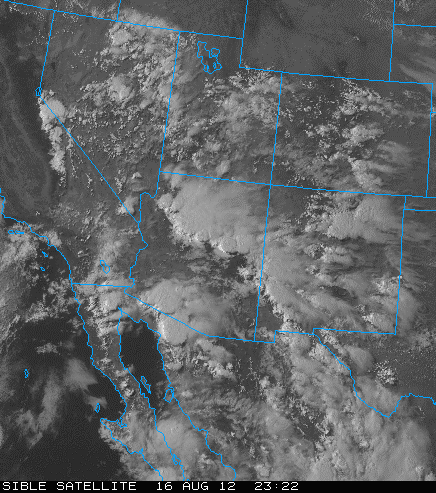
While there was substantial thunderstorm activity over much of Arizona yesterday afternoon (above is visible satellite image for 4:22 pm MST), there was little occurring over the southeastern quarter of the state. Very wet, but mostly cloudy through much of day. No outflows at all. All forecasts took a beating. yesterday provided an excellent example of how important the local heating and resultant orographic upslope flows are in modulating each days weather in the Southwest.
The ALERT network had no stations that reported rain yesterday afternoon for the 6-hours ending at 6 pm MST. However, light showers and isolated thundershowers developed around midnight and produced light rains early this morning. Here at house there was 0.13" in gauge. Across the ALERT network about 40% of sites had light rain between midnight and 6 am MST. Four sites had more than a quarter of an inch, but no amounts of half an inch were reported. This morning was extremely humid when I hiked along the Rillito.
Thursday, August 16, 2012
Another Tough Forecast Day
This morning the anticyclones at 500 mb (12 UTC analysis above) and 250 mb (12z UTC analysis below) are spatially aligned in a way that provides an excellent shear profile for organized thunderstorms across southern Arizona. The 500 ridge axis stretches from Boise, Idaho, southeastward to Del Rio, Texas. The steering winds at 500 mb over southern Arizona are from the east-southeast, while the winds at 250 mb are from the southwest. The 250 mb anticyclone is centered somewhere over northern Sonora.
The 12 UTC skewT for the Tucson sounding (above) indicates small CAPE from the SPC analysis, however, it appears that a new boundary layer (BL) will try to develop today (assuming we get afternoon sunshine - see previous post). The new BL will reach only to around 800 mb (see early WRF-GFS forecast sounding for TUS at 3 pm MST below), but will have considerable CAPE. It will also require considerable lifting to reach its LFC (probably somewhat similar to yesterday). The soundings at TUS, PHX, and YUM this morning, and the overall larger-scale pattern, are very similar to the situations described by Smith and Gall (1989, Tropical Squall Lines of the Arizona Monsoon. Mon. Wea. Rev., 117, 1553-1569). The early WRF-GFS forecasts a very active day across almost all of southern Arizona, with several lines of thunderstorm activity continuing through the night. Much of the forecast activity depends upon both considerable sunshine and strong, mesoscale outflows - a situation that may or may not materialize given the current cloudiness. I noted that the early WRF appeared to do a good job forecasting the MCS that was south of Douglas at sunrise. Obviously we need to check back on the 12 UTC WRF-GFS forecasts and Mike Leuthold's discussion!
Brief Summary Of Yesterday - 15 August 2012
The big news yesterday was that the high in Tucson reached only to a relatively cool 98F. The storms and rainfall yesterday avoided the low elevation deserts - although there were widespread sprinkles and traces of rain. One of those days where the model day 2 forecasts proved a bit better than the day 1 forecasts. Across the ALERT network 40 sites (a bit over 40% areal coverage) had rainfall between 6 pm MST last evening and 7 am this morning - of interest was the complete lack of rainfall (0% coverage) across eastern Pima County during the 6-hours from noon to 6 pm. Most rain in the ALERT network during the night was 0.55" at Arivaca. The above image shows regional radar (from NCAR RAL) at 7 pm last evening. Storms that approached Tucson from the east decayed over the mountains - apparently outflows across Tucson were not strong enough to produce new storms at lower elevations. The 00 UTC Tucson sounding indicated no CAPE, however, comparison to GPS PW (below) shows that the sounding was nearly a half inch too dry - a seriously bad RRS sounding. So, it remains a bit of a mystery what the CAPE situation was last evening. The heaviest rains were along the Borderlands - Nogales had 1.49" (with a severe wind gust to 58 mph just after 7 pm) and Ft. Huachuca had 0.94".
This morning (7 am MST IR image below), a decaying MCS was present south of Douglas, and an intense complex of storms was active over the southern GoC. There was heavy morning cloud cover over all of southern Arizona and northwest Mexico at sunrise, indicating another forecasting challenge for today.
Wednesday, August 15, 2012
Significant Outflows Yesterday Evening
There was another increase in thunderstorm activity yesterday - primarily at higher elevations and to the southwest of Tucson. The storms over southern Arizona and Sonora consolidated into a large MCS that moved west-southwestward over the northern GoC (see 10 pm MST water vapor image above). Outflows from this convective system moved across most of southern Arizona and surged rapidly northward along the Colorado River. The outflows reached to the Phoenix area, where there was wind and dust and some light showers. However, the outflows have increased PW across all of southern Arizona. The ALERT network had 65 sites with rainfall during past 24-hours (about 70% areal coverage). Amounts tended to be light, with only 6 stations having more than half an inch and 1 station to the southwest recorded just over an inch. Here at the house we had 0.53" as several thunderstorms drifted south from the Catalinas directly over our location. We had outflows from the north initially, and then strong outflows from the south around 8 to 9 pm - max gusts probably around 40 mph.
The GPS time-series of PW at U of A (above) shows the steady increase of PW this week with values now around an inch and a half. The visible satellite image at 7 am MST (below) shows a large mass of debris cloud covering western Mexico and much of southern Arizona. There appears to be a substantial vorticity maximum embedded in the cloud mass near the northern GoC.
The experimental, blended PW from CIRA (above at 6 am MST) shows that the larger-scale circulation associated with TS Hector has pushed very high PW about half way up the GoC. The extensions of higher PW (greens > 25 mm and yellows < 50 mm) into northern Sonora and Arizona have been generated by the convective outflows of the last two days - a nice example of the role of MCSs in pushing moisture northward due to cool, moist outflows.
This morning's Tucson sounding (skewT plot for 12Z above) shows deep moisture and a fair amount of CAPE. The winds aloft remain somewhat chopped up, but there appears to be steering flow from the east to southeast of about 20 kts in the 600 to 300 mb layer. It appears that the string of 100+ days has finally ended. Both the early WRF-GFS and the new NAM indicate storms over most of Pima County this afternoon, but again the models forecast the heaviest activity to occur from south to west of Tucson. This is a day to check the 12 UTC forecasts from Atmo's WRF model, as the forecast situation is quite complex.
Tuesday, August 14, 2012
Bit Of An Uptick Yesterday
Yesterday there were more thundershowers around than on Sunday. This was due to some slight increase in moisture and a bit of cooling in middle-levels (about 1.5C at 500 mb). Each model forecast I looked at during the day had somewhat different answers for eastern Pima County - my subjective feel is that the 12 UTC WRF-GFS had the best forecast, with more activity over the greater Tucson area, but basically all the models were struggling with the weak synoptic setting. The early WRF-GFS had forecast east winds through the day, but the winds became light and variable by noon. At 6 pm last evening 14 of the 93 ALERT network stations had received light, but measurable, showers (i.e., about 15% area coverage). This morning the total is up to 25 sites for rain during past 24-hours. Max amount was 0.83" at Whitetail up in the the Catalinas.
Today starts with an MCS still active over the northern end of the GoC (see 1415 UTC visible image above), and there are some associated showers out in western Pima County along the border. The 500 mb anticyclone has three circulation centers this morning: 1) over extreme northwestern Nevada, 2) along or just south of border south of Tucson, and 3) near Houston, Texas. Models shift the middle center northward over Tucson this afternoon. Certainly not a "dynamic" situation. Winds aloft are light and variable, but moisture is up a bit, and middle-level temperatures remain quite cool. It is unclear as to whether an outflow is moving northward into western Pima County. An outflow passed Puerto Penasco at around 5 am, but it did not appear to be very strong.
The early WRF-GFS again forecasts the most significant storm activity to remain over central and western Pima County - above is total forecast rainfall through midnight. However, the latest NAM (12 UTC run this morning) forecasts most storms and rainfall to occur over Cochise County, well to the east of what's forecast by WRF. The WRF 12 UTC runs may well have slightly different forecasts also. Basically a day to stay inside, in a cool spot, and observe what transpires during the afternoon.
The early WRF-GFS does forecast significant outflows this afternoon (see 10-m wind forecast valid at 8 pm this evening - below), so there remains a threat of strong winds late in the day. The eastern outflow, if it occurs, will bring significantly more moist air into all of Pima County.
Today starts with an MCS still active over the northern end of the GoC (see 1415 UTC visible image above), and there are some associated showers out in western Pima County along the border. The 500 mb anticyclone has three circulation centers this morning: 1) over extreme northwestern Nevada, 2) along or just south of border south of Tucson, and 3) near Houston, Texas. Models shift the middle center northward over Tucson this afternoon. Certainly not a "dynamic" situation. Winds aloft are light and variable, but moisture is up a bit, and middle-level temperatures remain quite cool. It is unclear as to whether an outflow is moving northward into western Pima County. An outflow passed Puerto Penasco at around 5 am, but it did not appear to be very strong.
The early WRF-GFS again forecasts the most significant storm activity to remain over central and western Pima County - above is total forecast rainfall through midnight. However, the latest NAM (12 UTC run this morning) forecasts most storms and rainfall to occur over Cochise County, well to the east of what's forecast by WRF. The WRF 12 UTC runs may well have slightly different forecasts also. Basically a day to stay inside, in a cool spot, and observe what transpires during the afternoon.
The early WRF-GFS does forecast significant outflows this afternoon (see 10-m wind forecast valid at 8 pm this evening - below), so there remains a threat of strong winds late in the day. The eastern outflow, if it occurs, will bring significantly more moist air into all of Pima County.
Monday, August 13, 2012
Severe Thunderstorms In California Yesterday
From Jim Means in Alpine, California:
Things have been pretty active out here in California the last couple of days. As usual, no rain at the homestead, but things have been close enough that we've been having official "thunder" days the last couple of days. Elsewhere in the county there have been some very strong storms, with multiple severe thunderstorm/flash flood warnings. I wonder how many places in the country have had a day like Ocotillo Wells did today? It's in the far eastern section of the county, off of Highway 78. It had a high of 120, a low of 97, and was under severe thunderstorm and flash flood warnings. Must have been pretty steamy out there. Even heard an unconfirmed report of a tornado in Riverside county.
Above is SPC storm reports map from 12 August 2012.
August Heat Continues
Photo above shows a weak tower trying to build near the University around 4 pm yesterday afternoon. Was icing out faster than it could grow and was mostly gone within about 15 minutes. High temperature yesterday at TUS was 109F. Only isolated towers around, with Nogales and Sells reporting light showers in the afternoon.
Today there is a Plains cold front pushing westward into far southeast Arizona, and El Paso has strong easterly winds in low-levels this morning. The early WRF-GFS forecasts keep what little storm activity there will be today out to the west of the Tucson metro area. The model forecasts easterly surface winds (below is surface plots from the 4 pm MST model forecast); hot temperatures; and dewpoints in the 30s - another scorcher.
East Pacific IR image at 1130 UTC (above) shows TS Hector southwest of Baja, as well as a large MCS over the southern GoC. The 1430 UTC visible image (below) indicates that the MCS is moving north-northwestward up the GoC fairly quickly. It continues to appear that MCS activity and Hector will act in concert to push moist, low-level air northward up the GoC the next couple of days.
Sunday, August 12, 2012
Another NWS Project
The
Innovation Portal--a dynamic environment to facilitate idea
sharing, innovation and collaboration. The Innovation
Portal provides a common, virtual, interactive environment for
field developers, meteorologists, other NOAA/NWS personnel, and
ultimately partners to collaborate and exchange innovative
ideas, concepts, research, and science and technology
information at any time and from any geographical location or
time zone. Thus, the Innovation Portal allows for ideas and
concepts to leverage the expertise and resources of different
offices and innovators at minimal cost. The Innovation Portal
spans from idea creation to development and implementation to
help transition concepts from research to operations and to
improve innovative outcomes and future NWS services.
-----------------------------------------------------------------------------------
This project is apparently related to the Weather Ready Nation efforts, commented on
in earlier posts. Beam me up Scotty, I've got an idea!
Aye, Laddie, I'll drink to your idea.
Heat Continues
The string of very hot days continues (Friday TUS hit 108F, and yesterday 105F). Strong gradient of low-level moisture continues across southern Arizona - driest along New Mexico border and wettest along the Colorado River. There was a bit of an increase over eastern Pima County yesterday that led to isolated thunderstorms during the early afternoon - TUS had a thunderstorm with gusts to 46 mph and 0.10" of rain. We were away, so I don't know exactly what happened at house - but rain gauge was dry when I checked. Across the ALERT network a bit over 20% of the sites had rainfall - amounts were light with only 4 stations reporting just over a quarter of an inch. The above photo was taken looking west from the Santa Rita Abbey at about 1:30 pm - a light thundershower was veiling the Santa Rita Mountains at that time - lightning, thunder and spits of rain at the Abbey.
This morning's Tucson sounding (skewT above from SPC) shows a very deep, residual boundary layer that reaches almost to 500 mb. Some potential for a bit of CAPE this afternoon, especially if more moist air sloshes in from the northwest. The sounding, by afternoon, will be favorable for dry microbursts, if elevated convection produces some precipitation into the super-heated boundary layer.
The CIRA experimental, blended PW product (above at 13 UTC this morning) depicts the east-to-west moisture gradient across southern Arizona. Green shades are >25 mm and yellow shades are <50 1330="1330" 70="70" able="able" air="air" an="an" at="at" baja="baja" be="be" because="because" below="below" certainly="certainly" convection="convection" deep="deep" during="during" east="east" extends="extends" extremely="extremely" eye="eye" finally="finally" goc="goc" hector.="hector." hector="hector" high="high" image="image" interesting="interesting" is="is" keep="keep" low-level="low-level" may="may" mm.="mm." mm="mm" morning="morning" most="most" mouth="mouth" mt="mt" northward="northward" note="note" of="of" on.="on." p="p" perhaps="perhaps" purple="purple" push="push" shades="shades" something="something" southern="southern" southwest="southwest" storm="storm" that="that" the="the" this="this" tip="tip" to="to" tropical="tropical" up="up" utc="utc" week.="week." well="well" white="white">
50>
Subscribe to:
Posts (Atom)