skip to main |
skip to sidebar
The high cloudiness yesterday afternoon kept the high temperature at TUS at 98 F and warmest day of week turned out to be Thursday at 99 F - so more thermometer watching for the first 100 F day.
The WRF-GFS continues to forecast isolated thunderstorms this afternoon near and east to north of the metro area. Forecast of composite radar echoes above is valid at 2:00 pm this afternoon.
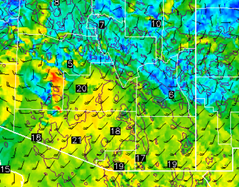
The model also forecasts strong winds for tomorrow afternoon as another 500 mb short wave moves by. The 10-m wind forecast below is valid at 2:00 pm tomorrow afternoon. The very strong winds over in the Big Bend area are being produced by severe thunderstorms in the model forecast. The NAM version of the model forecasts especially strong winds along the flanks of the Huachuca Mountains tomorrow.
The two MIMIC blended PW analyses here show the progression of higher moisture northward up the GoC - above is for 12 UTC this morning and below is from 24-hours earlier. Values of PW well over an inch have reached northward to 30 degrees north. This is quite some push up the GoC for mid-May.
The WRF-NAM forecasts from Atmo at 06 UTC continue to indicate a chance for high-based thunderstorms over parts of Arizona tonight and tomorrow. Forecast of composite radar echoes above is valid at 2:00 pm MST tomorrow afternoon. Forecast below is for precipitation through midnight tomorrow. Finally, a bit more to watch than just the thermometer.
Before the next 500 mb short wave affects the Southwest this weekend, there is a period of southerly flow from low latitudes that advects higher moisture into southeast Arizona. Cooler and moist air is also trying to move westward from southern New Mexico and the Big Bend country. So, there is a bit of an interesting situation developing. I took a look at the 06 UTC WRF-NAM forecasts on the 5.4 km grid this morning (the WRF-GFS is running a bit late).
Above is the forecast for precipitable water (PW) valid at 6:00 am MST this morning - of most interest is the higher PW over the southern GoC. The model forecasts a surge-like northward push of higher PW that reaches to northern Sonora by 6:00 am tomorrow morning (just below). The higher PW air moves into southern Arizona by 6:00 am on Saturday the 14th (second below). The moisture from the east fizzles out along the Continental Divide and never makes it into Arizona in the model forecasts.
However, the northward push of lower-latitude moisture is quite impressive, especially around 700 mb - forecast below is for 700 mb RH valid at 9:00 am tomorrow morning. The WFR-NAM actually forecasts some thunderstorms near the border and light showers over parts of southeastern Arizona. So it is possible that we'll have a brief threat for dry thunderstorms along the Borderlands tomorrow afternoon - this would be the first such setup of the early summer and will be something to keep an eye on.
Phoenix photographer and storm chaser Mike Olbinski was off a bit to the east yesterday. Above is one of his photos of the destructive tornado that struck near Norman, Oklahoma. Photo is near Wynnewood, just a bit south of the famous Wayne and Payne exit on I-35. Mike's web page is at http://www.mikeolbinski.com/
The new week has dawned bright and clear as per above view of the Catalinas. The big weather question for coming week will be whether or not we'll see our first day with 100+ temperatures at the airport.
The large 500 cyclone that was off California on Friday (see previous post) has now pulled well inland and is centered over the Nebraska Panhandle this morning (500 mb analysis above for 12 UTC is from NCAR RAL). There is a weak, trailing short-wave that will head across northern Mexico today. But, the chance for rain has ended here, with most of southeast Arizona seeing only winds and dust over the weekend - certainly nothing in the gauge here. The detected CG flashes below (from Atmo and Vaisala) for 24-hours ending a bit after midnight last night do show that there were some thunderstorms over the northeast half of Arizona as the system pulled by. Looks like a quiet week on tap, with just some gusty afternoon winds and rising temperatures.
This morning's 12 UTC NAM analysis of the 500 mb level shows what a complex system will be crossing the Southwest during the next three days. Note that the NAM analysis indicates 6 vorticity maxima (indicated by the "Xs") circulating around the closed low, that is centered near Los Angeles.
Below are two NAM forecasts for 500 mb valid at 24-hours (12 UTC on Saturday, directly below) and at 48-hours (12 UTC on Sunday, second below). The forecasts indicate two distinct vorticity maxima will cross southeastern Arizona during this period.
As for the 06 UTC GEFS plumes for QPF, the forecasts for TUS (the airport, above) continue to be all over the place. Two things of note - the amounts at TUS are very small and the operational member is the driest of the forecasts (as it also is out at Yuma). However, only two hours up I-10, the GEFS forecasts are quite different (below) - 100 % of the 21 members forecast measurable precipitation at Sky Harbor with amounts ranging from 1/10 to 6/10 of an inch. The timing is also much more distinct, with the Phoenix area main event forecast for tonight into Saturday morning.
The WRF forecasts also continue to indicate that the most significant showers and thunderstorms will occur to our west and north. There's not much to do now except to observe how all this evolves. But what a difference a few miles makes - assuming the models verify well.
The MIMIC PW analysis for 12 UTC this morning is shown above (from CIMSS at Univ. of Wisconsin). There is some indication of the middle and upper-level closed low that will impact the Southwest through the weekend west of central California. This system is forecast to shift slowly southeastward as several distinct shortwaves rotate around it. The PW remains very low to the south of this system, making the forecast for showers uncertain, as it has been the last couple of days.

The 06 UTC forecasts from the WRF model at Atmo are quite different for late Saturday and Sunday. The NAM variant picks up enough moisture to support light showers and thunderstorms over Pima County beginning Saturday night and continuing Sunday - WRF-NAM precipitation through 11:00 am MST Sunday morning is shown above. However, the GFS variant remains dry over most of southeastern Arizona, as per the same forecast below. At this time we can be confident that it will be unsettled over the weekend, but details remain to seen.
However, the models continue to forecast strong winds this afternoon over much of Arizona - forecast below is from the WRF-GFS and is valid at 1:00 pm this afternoon. So, more dry and dust this afternoon.
The GEFS plumes from 06 UTC forecast a mixed bag for chances of rain at the airport over the weekend, as per above. The range of QPF within the 21 members goes from 0 to about half an inch, with a very wide range for the timing also.
However, the models' plumes are in close agreement for the winds (above) with speeds around 20 kts both tomorrow and Friday afternoons. The current NWS forecast (below) for the high-resolution airport grid point reflects the GEFS model forecasts. Note that the forecast high for today flirts with the 100 F mark - ugh.
I took a look at the 00 UTC WRF-GFS forecasts on the 5.4 km grid from Atmo to get a feel for why we continue in such a dismal run of weather events. Shown above is the model's forecast of accumulated precipitation through 5:00 pm MST on Sunday, May 8th. It's obviously very dry for southeast Arizona.
The 500 mb forecast below is valid at 5:00 am on Saturday, May 7th. The 500 mb closed low is centered just south of Las Vegas and is moving across northern Arizona for the coming event. The precipitable water forecast for the same time (bottom) indicates that the system is never able to pick up much water content from lower latitudes and the system has to work with what it brings in from the Pacific across the California and northern Baja mountains.
Bottom line is more wind and dust and just slight chances of sprinkles and light showers - certainly no good news here for allergy suffers.
Jack Diebolt alerted me that the problems continue at Yuma early this morning. All of these images are from about 6:45 am MST. Visible satellite image above shows the clear skies that cover all of southern Arizona. Below is base scan (0.5 degree tilt) reflectivity from the NWS Yuma radar.
Above is the storm total radar-estimated precipitation product. Somehow the rock echoes are fooling the precipitation algorithms - but again, I have not kept up with the algorithms as the radar capabilities have been enhanced during recent years. Note that some points are showing estimated rain amounts of around four inches. Some national maps of radar estimated rainfall have eliminated the false rain estimates via QC procedures, while other products indicate rain in the Yuma/Baja areas.
Out of curiosity I also looked at the current hydrometeor classification product (below - based on the dual polarization signals). Most of the echoes are classified as "biological," however, many grids indicated rain or dry snow.
The Yuma radar status message currently does not indicate any problems with the radar or its products.
I happened to notice that the Yuma radar was indicating considerable echoes at 11:24 am MST this morning in the base scan (0.5 degree tilt, above). A closer look indicated that the echoes were all located along terrain features, and indeed the 1.5 degree tilt (below) at the same time indicated almost no echoes. Thus, a fairly substantial failure within the ground clutter detection and removal algorithms seems to have occurred. I am no longer familiar with the details of these algorithms, since the addition of dual polarization capabilities to the radars, so I can not speculate about what might have gone awry. Since the Army does not take soundings on the weekends, there are no data available to determine if a strong inversions was present. However, at 2:00 pm the problem continues, probably indicating that there has been a failure with the data processing systems. If anyone knows more, please let me know.
Stratus above washes over south end of Kitt Peak at 7:00 am MST this morning. There was considerable thunderstorm activity over Arizona yesterday - below is 24-hour hour flash density ending at 7:00 am (from weather.graphics and Vaisala). We had a few sprinkles here at the house yesterday afternoon, and have ended April with a Trace. There were 7 ALERT stations on the north side of the Catalinas that had measurable rainfall - max amount was 0.16".
The GEFS QPF plumes from 06 UTC last night (above) are a bit all over the place - both for today and also for next weekend. Today there is a bit of CAPE again, and the WRF forecasts from Atmo at 06 UTC both forecast some light showers for spots in eastern Pima County.
By next weekend the GEFS 500 mb mean and spaghetti plot (below, valid at 5:00 pm MST Saturday) forecast another blocking pattern with a deep cyclone over the Southwest. So, another interesting situation on tap.
There is more activity around this afternoon and showers extend further south and east than was forecast by the 06 UTC WRF runs. Webcam view above is looking north from Kitt Peak, and below is similar from campus. The composite radar at bottom (from PHX) is from just before 3:00 pm MST. There is a smell of rain in the air here and I'll hope for a late afternoon sprinkle or shower.
First - Mike Leuthold's WRF forecast discussions will be posted at http://arizonawrf.blogspot.com/ this spring and summer. He did a post yesterday that keyed on the possibility of thunderstorms and winds this afternoon in Pinal and Maricopa Counties.
This morning's newspaper headlines actions by the ADOT after several crashes in blowing dust on I-10 east of Tucson. In this day of high-resolution observations, model forecasts, and grid point forecasts from the NWS (as well as inexpensive webcam capabilities), the ADOT will apparently implement a 1950s kind of action. They plan to change the I-10 speed limit from 75 to 45 mph along a stretch of the highway from Bowie to San Simon, Arizona.
Of course, the next traffic incident may well occur in some other dust-prone section of I-10.
Another closed low at 500 mb will swing across Arizona today, producing more unsettled weather for the last day of April. The 12 UTC NAM forecast above is valid at 5:00 pm MST this afternoon and indicates a quite strong vorticity maxima with this low. The current NWS Tucson forecast of maximum wind gusts expected this afternoon is shown below, and indicates strongest wind gusts along the Borderlands from Nogales east to New Mexico.


Last night's 06 UTC forecasts from Atmo's WRF model continue to forecast thunderstorms over parts of Pima, Pinal, and Maricopa Counties this afternoon. The forecast of composite radar echoes above is valid at 6:00 pm MST this afternoon (note that reds indicate storm reflectivities above 50 dBZ). The model forecasts strong 10-m winds (below, valid at 5:00 pm) from central Pima County northward into Maricopa County - red areas indicate wind speeds of 30 kts (35 mph) and higher with gusts likely increasing speeds substantially. If the model proves accurate, the infamous blowing dust zones between here and Phoenix may be active this afternoon.
Both the NAM and GFS versions of the current WRF forecasts keep the shower and thunderstorm activity to our north again, but with the Catalinas having some chance for storms. Although forecast CAPE (forecast skewT below is for PHX and is valid at 4:00 pm this afternoon) is small, storms would be high-based and with cold updrafts, favoring growth of graupel and perhaps small hail - thus the forecast of high reflectivities.
Our interesting weather continues, but the rain gauge here at the house remains empty except for dead spiders and dust.


