Tuesday, August 22, 2023

Widespread Rainfall Yesterday

View looking toward Redington Pass this morning at about 5:50 am MST.

Plot of detected CG flashes (below, from Atmo and Vaisala), for 24 hours ending at 0733 UTC this morning, shows heaviest concentration of flashes extending from Santa Cruz County to Pinal County, crossing the metro area.

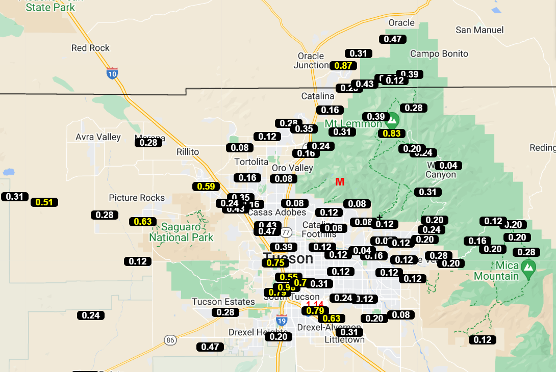

Rainfall was obeserved at every ALERT site (except Arivaca) during the 24 hours ending at 7:00 am this morning, with quite a few sites reporting over half an inch. The airport had 0.71" with gusts to 48 mph; Atmo reported 0.71" with gusts to 42 mph; DM had 0.42" with gusts to 43 mph; and we had only 0.18" (not sure about wind gusts here).


At 500 mb this morning (above from SPC) there is a massive 600 dm+ anticyclone centered over northern Missouri. Tropical Storm Harold is coming ashore near Corpus Christi, Texas, currently, and its remanants will head toward the Big Bend and southern New Mexico. It's not clear to me whether the wave with Harold will make to southern Arizona, although models are currently forecast this to occur.


Tucson sounding this morning (above) was truncated at 200 mb. The sounding shows a classic onion shape, following yesterday's rains. There is little, if any, CAPE for a deeply mixed BL. Following yesterday's rains, I would expect most of the area to be suppressed today. Which is what the 12 UTC run of the WRF-RR model at Atmo indicates (below). However, the NWS is keeping 30 to 40 percrnt POPs for the airport through Thursday (second below).


Monday, August 21, 2023

More Showers


View of Catalinas at 5:50 am MST this morning, with some rain drops on the lens.

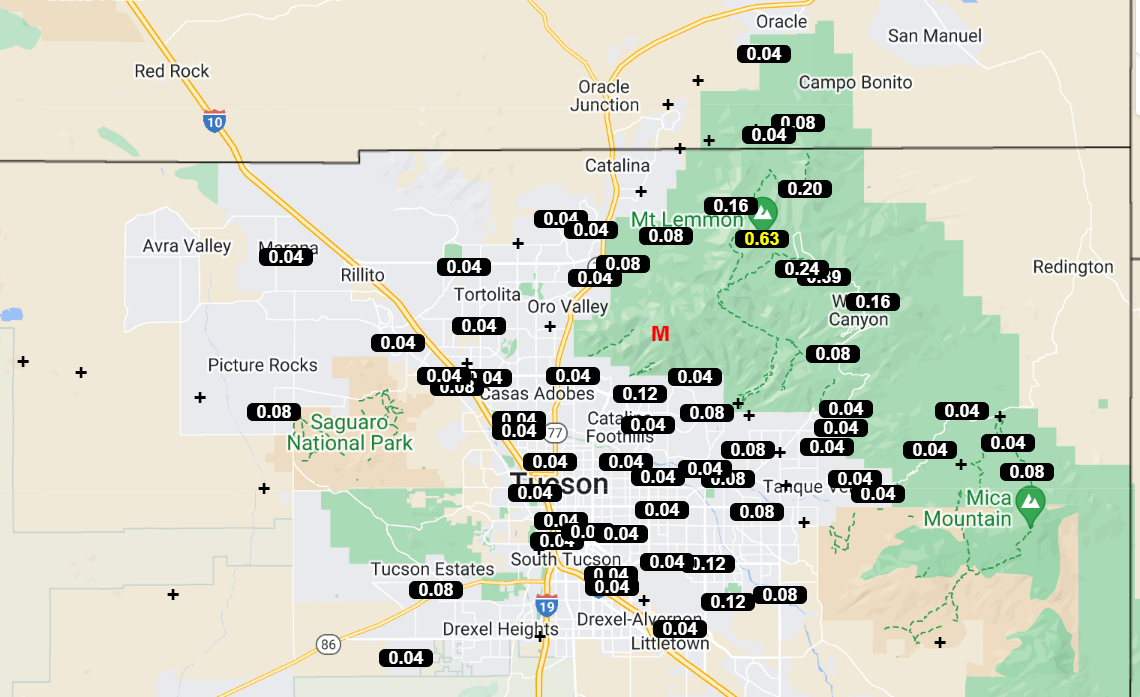
Thunderstorms yesterday stayed far to the north and southeast of Pima County (above plot is for CG flashes detected for 24 hours ending at 7:30 am - from Atmo and Vaisala).

Numerous sites across the ALERT network had rainfall (mostly light) during 24 hours ending at 7:30 am. Here at the house there was 0.04" in the gauge this morning from nighttime showers.


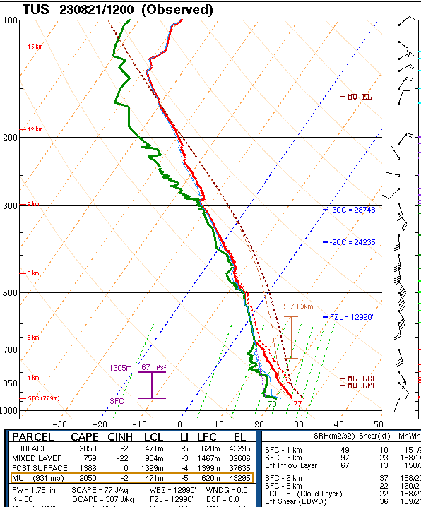
Plot of TWC/TUS morning sounding (above) shows very deep moisture, as well as some mixed layer CAP E (not as much as shown for surface parcel). Southerly winds are fairly strong from 700 to 300 mb.

This morning's 12 UTC WRF-RR forecast indicates that rains this afternoon and evening will stay mostly to the west of I-10. Current NWS morning forecast is shown below for today through Wednesday.

Sunday, August 20, 2023

Sunday Morning Update


Interesting cloud formations over the Catalinas at 7:00 am MST this morning - note the stacked, lenticular clouds.

As expected after a widespread rain event, the area was almost totally suppressed yesterday, with no rain reports across the entire ALERT network (plot above for 24 hours ending at 8:00 am this morning).

The morning sounding (above) from TWC/TUS continues quite moist but with almost no mixed BL CAPE by afternoon. Note the strong southerly winds aloft.

 From the 06 UTC WRF-GFS, forecasts for the 500 mb level valid at 12 UTC this mornin (above) and at 5:00 pm this afternoon (below). Dissipating Hilary moves rapidly northward into southern California, on the west side of a massive, 600 dm anticyclone over the central US.


 Morning forecast from NWS (above) again keeps POPs very high through tomorrow night. Detailed forecast calls for wind gusts as high as 47 mph this afternoon.

Morning track forecast for Hialry, from the NHC (above). Forecast below from the 06 UTC WRF-GFS shows the precipitation forecast (on 5.4 km grid) through 6:00 pm tomorrow afternoon. Note the very large amounts California to Nevada, with Tucson area just on the periphery of the large rain swath.

Saturday, August 19, 2023

Evening Storms


Aother presunrise, colorful sky looking toward the Rincons about 5:40 am MST this morning.

Some thunderstorms in eastern Pima County last evening - plot of detected CG flashes through 0803 UTC (below) from Atmo and Vaisala.


Rainfall yesterday was fairly widespread across the ALERT network (as per plots for 24 hours ending at 7:00 am this morning above and below). Note the report of 2.01" down at Tubac.

Local rainfall amounts as per: airport 0.79", DM only 0.07",  Atmo 0.14", and 0.11 here at the house. The airport recorded a severe wind gust to 62 mph, with thunder, yesterday evening; however, report of same appears not to have gotten to SPC.


Hurricane Hilary remains a low-end Category 4 storm this morning. Current NHC forecast track (above) continues to take the storm across northern Baja and southern California.

Current rainfall forecast (from 06 UTC WRF-GFS through midnight tonight) keeps mostly light rainfall across eastern Pima County.

Friday, August 18, 2023

Local Showers Plus Hilary

View looking toward the Catalinas at 5:45 am MST this morning, showing heavy clouds with some color.

Plot of detected CG flashes (from Atmo and Vaisala) for 24 hours through 0733 UTC this early morning shows widespread storms across Arizona yesterday. There were 10 reports of severe winds yesterday evening, and these reached from Picture Rocks north of Tucson out to Bullhead City.


ALERT data through 7:00 am this morning show widespread rain, except across much of the metro area. Here at house we had thunder and 0.04" a bit before midnight. There were several amounts over half an inch, with one site in the Catalinas having over an inch.


The Tucson morning sounding is back! The skew-T above shows a classic onion profile that has little CAPE for a deep-layer mixed parcel. Sounding would seem to indicate little chance for storms today at low elevations; however POPs remain high - as per the morning forecast from the TUS forecast office - down toward bottom.


Big weather story next several days will be Hurricane Hilary, which has intensified to Category 4 level with 125 kt winds this morning - visible image of Hilary above is from 1420 UTC. Current track forecast from NHC is below. Hilary threatens to bring extremely heavy rains to southern California.


Current NWS forecast keeps high POPs through the next seven days - forecast above covers through the weekend. Forecast below is from the 06 UTC WRF-GFS and shows total precipitation through 11:00 am on Monday the 21st. Looks like a very interesting weather weekend!

Thursday, August 17, 2023

Quick Update


ALERT data for 24 hours ending at 7:30 am MST this morning. Rainfall was scattered here and there across the network, with heaviest amounts on norhwest side of the Catalinas. There was thunder here but no rain. Storms avoided much of the metro area.


Hurricane Hilary has intensified rapidly today and is, or soon will be, a Category 3 storm (image above is from 2240 UTC this afternoon). The NHC forecast this afternoon (below) takes Hilary along the western edge of Baja and eventually into California as a depression. The rainfall directly associated with Hilary will stay west of here, but the storm will bring a substantial push of very moist air into southern Arizona. Thus, storm activity should continue through the weekend, with hopefully some rain here at the house.

Wednesday, August 16, 2023

Continued Chance Showers


View toward Rincons at a bit after 6:00 am MST this morning.

There were no detected CG flashes in eastern Pima County yesterday - above plot through 0803Z (from Atmo and Vaisala). No rainfall reported across ALERT network, except for 5 sites as per below; al which had very light amounts. Yesterday morning's forecasts did not verify well.


The 12 UTC WRF-RR forecasts scattered showers again for the metro area - above forecast valid through midnight tonight. Current NWS forecast for the airpport (below) indicates 30 to 60 percent POPs each period through Friday night.

The tropical disturbance to the south continues to be forecast by the GFS to move northward much faster than shown on the NHC morning outlook.

Tuesday, August 15, 2023

Scattered Light Showers Yesterday

View of Rincons at about 5:30 am MST this morning.


Plot of detected CG flashes (above, from Atmo and Vaisala) for 24 hours shows a few flashes in eastern Pima County, mostly avoiding the metro area. ALERT data below show light rainfall amounts scattered here and there across the network.


At 500 mb this morning (above from SPC) the large anticycloneappears to be centered along the Colorado - New mexico border. There was again no sounding from TWC/TUS, and I suspect that there will be a significant outage, although there's been no explanation on NWS webpage.


The forecast from the 12 UTC WRF-RR (above) shows scattered light precipitation across Pima County through 6:00 am tomorrow morning (some other WRF runs forecast heavier amounts over our area).The morning forecast from the NWS (below) continues to indicate POPs of 30 to 50 percent for the airport through Wednesday night.


Looking south, the NHC morning outlook for seven days (above) indicates that development is very likely off the southern coast of Mexico, wth movement toward the northwest. The GFS forecast for thickness values at seven days (below) shows the TS/hurricane west of northern Baja - considerably faster than the NHC outlook.