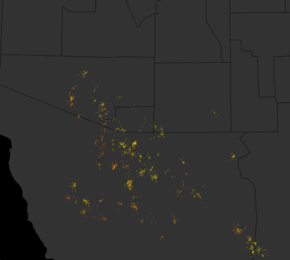
The WRF model forecasts yesterday were quite good (previous post), keeping thunderstorms mostly south and west of the metro area over higher elevations. Above graphic shows detected CG flashes yesterday afternoon - essentially from about 1:00 pm MST through 6:00 pm. Web cam view below - looking south from Kitt Peak - captured what was the heaviest storm of the afternoon at 2:37 pm located east of Baboquivari. The blended radar/gauge rainfall estimate map second below (from Flood Control District of Maricopa County) indicates that this storm may have produced over an inch of rain. Across the ALERT network in Pima County only 4 sites had rain yesterday - amounts all less than a tenth of an inch.
The WRF forecasts from 06 UTC last night indicate only very isolated convection this afternoon from the Santa Ritas up across the Rincons - and this only in the NAM version of the model. The morning sounding has no CAPE at TWC, as middle-levels have warmed, killing what little CAPE was around yesterday.


Finally, the long range model forecasts were indicating an active period to close out October - see "Unsettled" post three below. But, now those models keep Arizona and New Mexico mostly dry through the end of the month. The forecast below is from the 00 UTC WRF-NAM on 5.4 km grid for total precipitation through 5:00 pm on October 31st. The light precipitation indicated over southern Arizona actually was forecast for the first 6-hours of the forecast period. Looks like fair, warm to hot conditions will prevail through Halloween - assuming these latest forecasts verify.


No comments:
Post a Comment