
There was a train derailment yesterday east of I-10 and north of Cortaro - where very heavy rains have occurred two of last three days (APS power station is in background).

Storms developed by mid-day yesterday and were disorganized, here and there, with little organization. The yellow circle (above - flashes for 24-hours ending at 0730 UTC last night from Atmo and Vaisala) of numerous CG flashes is just northwest of here, where the train derailed.
Plot below is from MesoWest and shows 24-hour rain reports ending at 7:00 am MST this morning. Very large amounts again from Oro Valley out toward Marana. Ron Holle reported another 1.11" at his place in Oro Valley. Here at house we had rumbles of thunder, several nice cool outflows, but only sprinkles and slight showers - total in gauge at end of day was a meager 0.04".


The situation this morning appears very similar to yesterday. The 250 mb 12 UTC analysis from SPC (above) shows the inverted trough stalled this morning along the lower Colorado River Basin. The analysis also indicates three distinct anticyclonic circulations within the massive high aloft.
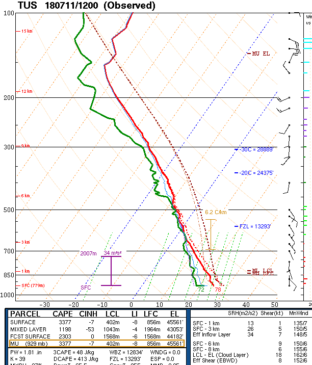
Morning skew-T plot of TWC upper-air data (below) is quite similar to yesterday, but with PW and CAPE even higher. The entire Southwest is just sopping wet. The wind profile remains very light, so I would expect somewhat disorganized storms again today, with threat of heavy, local rains continuing.
I took a quick look at the 06 UTC WRF runs from Atmo - both versions forecast some sunshine late morning, before storms begin developing. Both versions also bring very strong thunderstorms across parts of the metro area. The LFM version develops the storms earlier than the GFS version, which looks to fit the sounding better. I'll leave it up to Mike L. to decipher the various morning WRF runs and to figure out which forecast scenario is most likely.
No comments:
Post a Comment