
It was a big severe thunderstorm outbreak day yesterday - there are numerous photos of damage across the Phoenix metro area, as well as posts by local storm chasers. Here I show: large storm north of Kitt Peak as it heads toward Gila Bend; Mike Olbinski photo of the large haboob storm that went along I-8 all the way to Yuma - view is from I-8 looking east toward Sentinel, which is west of Gila Bend; and second below shows large saguaros down somewhere in Phoenix area (I've never seen this before and it looks like perhaps these were in an over-watered spot?).


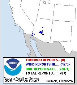
Storm reports received at SPC yesterday (above) for Arizona - note that videos from chasers indicate that numerous more severe storms likely occurred across the wastelands between I-10 and I-8 from Phoenix-Casa Grande all the way west to the Colorado. Most of the 47 wind reports at SPC were from Arizona. The 24-hour plot of CG flash density (below - from weather.graphics and Vaisala ending at 1130 UTC this morning) shows the very active day (second in a row) over most of Arizona, except the southeast corner, again.


The severe thunderstorms occurred ahead of the IT that moved across Arizona, which is now located along the Colorado River Basin well to our west (above 12 UTC 500 mb analysis from SPC).

The morning sounding (above from SPC for TWC) is extremely wet this morning with considerable CAPE again today. Main problem will be whether enough heating can occur to release this CAPE.

The 14 UTC visible satellite image above shows the widespread cloudiness and shower activity, which will act to suppress things. Note that it was raining lightly at sunrise this morning - Trace here yesterday but over an inch at the airport.
I looked at the 06 UTC WRF runs from Atmo, and it seemed to me that the NAM version had best forecast the morning showers and the observed TWC sounding. That version of the forecast model is much more active over eastern Pima County this afternoon with significant storms moving northward across parts of metro area. I'll be watching to see if the clouds thin and we get some mid-day sunshine. The NAM version skew-T forecast for TWC (below valid at noon) indicates considerable warming of BL below 700 mb - but will this materialize?

No comments:
Post a Comment