
Thunderstorms developed around the metro area, and the Sky Islands, between 5:00 and 6:00 pm MST yesterday afternoon. View above from campus was at 6:00 pm, with storm on the western Catalinas heading toward Oro Valley.
Plot below shows detected CG flashes for 24-hours ending at 5:00 am this morning (from Atmo and Vaisala) - was a very active day for most of Arizona. Most notable area that was suppressed was along a broad swath from Phoenix to Douglas. In eastern Pima County most active area was from Catalinas westward toward Marana.
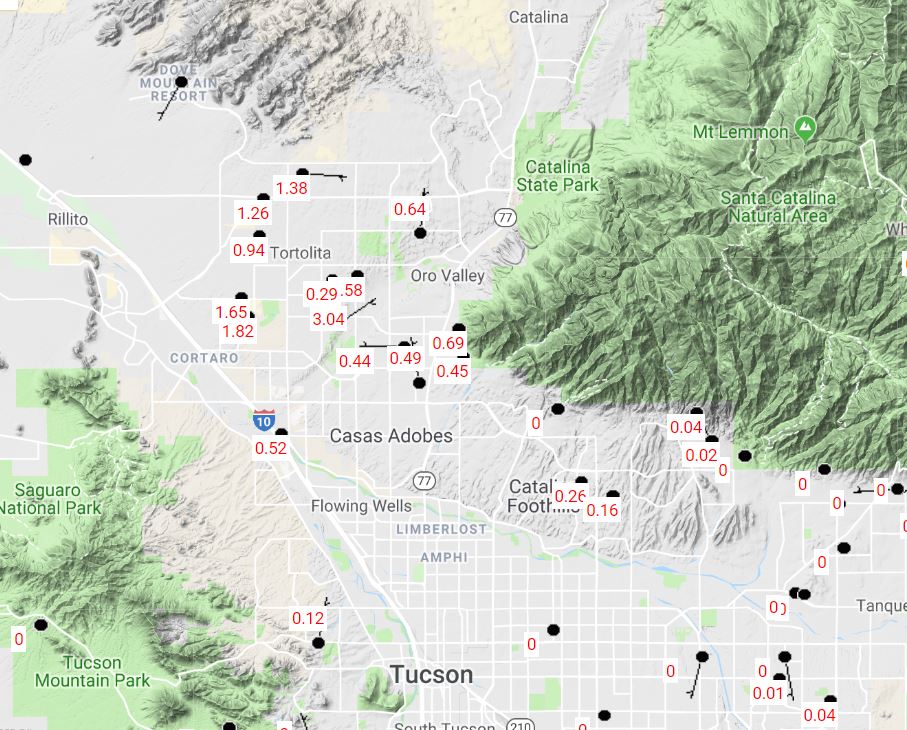
Second below is 24-hoour rainfall from MesoWest ending 7:00 am this morning - the region west of the Catalinas, where a number of cells repeatedly moved, had very heavy rains. One station reported over three inches of rain, and several others had over an inch. Ron Holle emailed that he had measured 1.10" and that his wash was flowing.
However, most of metro again had thunder but little rain or light showers - TUS and DM had a trace, while we had 0.10" here. Other parts of the low desert experienced strong outflow winds and dust storms - including Phoenix, Yuma, and Casa Grande, where visibility was essentially zero around 9:00 pm. There were reports of severe winds and damage from the Oro Valley area and also from Buckeye (which is west-southwest of PHX), where several semis on I-10 were overturned. Certainly the most active storm day so far this summer.


Today should be another active day as an inverted trough (currently from north central Mexico northward across New Mexico. The 12 UTC streamline analysis for 250 mb (above from SPC) shows that this IT is very pronounced and that there should be significant difluence ahead of it over southeastern Arizona.

The morning skew-T plot for TWC upper-air data (above from SPC) indicates that PW is now up over 1 1/2 inches and that there will be moderate to strong CAPE this afternoon, with values perhaps reaching to 1500 to 2000 J/Kg. The steering winds are are strong from the east-northeast, but this morning winds in the upper-troposphere are also strong and would try to move anvils out ahead of convective cores. The visible satellite image below (from 6:45 am) is very noteworthy since there are broad areas of debris cloud, and some active showers, in all directions from here. But southeast Arizona and northeastern Sonora are quite clear - so very nice heating and storms earlier than yesterday.
The 06 UTC runs of WRF-GFS and NAM from Atmo indicate a number of areas across southern Arizona will be impacted by severe thunderstorms this afternoon. The forecast sounding for TWC at bottom is from WRF-NAM and is valid at 2:00 pm this afternoon. The approaching, inverted trough has produced drying above 500 mb, and mostly importantly has modified the vertical wind profile considerably. The forecast profile would favor more local areas with heavy rainfall and also possible, strong, wet downbursts. very interesting day on tap.


No comments:
Post a Comment