Bands of showers crossed the metro area off and on yesterday, producing some thunder and widespread rainfall. Here at house we measured 0.20" with heaviest band being the first at mid morning, which produced 0.10" in about 15 minutes. Across the ALERT network all sites except for 5 had 0.04" or more; 28 sites had half an inch or more; and 2 sites had more than an inch. Event turned out more productive for rain than I thought it would be.
Also of note - low here at house was 48 F this morning and coolest so far of Fall.
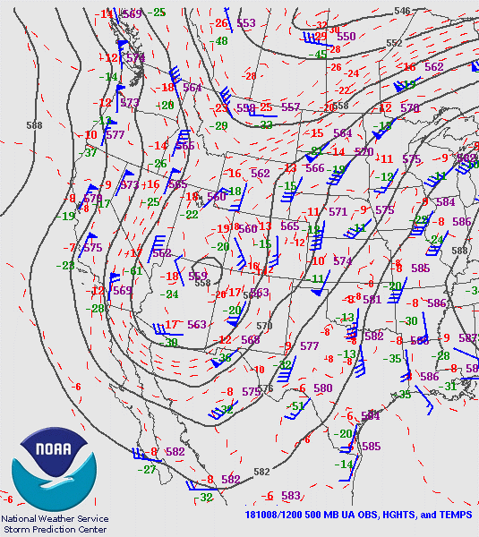
Morning 500 mb analysis, below from SPC, shows the closed low has moved to near the Four Corners, with strong northerly winds along entire West Coast. However, forecast models continue to forecast several short-waves coming down back side of trough - this actually shifts the weakening trough westward and also allows it to pick-up Sergio.
The MIMIC TPW analysis below is for 13 UTC this morning. The Southwest and northwestern Mexico are fairly dry, and high PW with Sergio remains far to the southwest of Baja - so models forecast huge changes by end of week. Note also that Hurricane Michael is located over the Straits of Yucatan and is moving toward the GoM.
Most weather attention will be on Michael (IR image above is from 14:32 UTC) during next couple of days as it moves toward a landfall in the Southeast. Hurricane Watches have been issued for the GoM's northeastern coast - as per morning NHC track forecast below.
Hurricane Sergio has continued a westward drift during last 24-hours, and is now near 15 N and 130 W. The storm's eye is VERY large and ragged, all-in-all a very strange situation, especially if it eventually moves across Baja from its current position far to southwest of northern Mexico.
The NHC morning forecast track below still loops Sergio around toward the northeast, weakens it dramatically, and speeds the storm's motion up considerably on Wednesday and Thursday. So, Sergio may yet impact our part of the Southwest by the end of the week - we'll watch closely to see if this actually happens.
Monday, October 08, 2018
Subscribe to:
Post Comments (Atom)


No comments:
Post a Comment