Monday, September 16, 2024

Showers Yesterday


View of Catalinas with heavy cloud cover at 6:30 am MST this morning.


Widespread showers occurred yesterday, with quite six sites recording over an inch of rain. Not much here at house with thunder but only 0.03" - TUS reported thunder and  0.11", while Atmo and DM had 0.04" with thunder at DM.


The plot of detected CG flashes for 24-hours ending at 0803 UTC (above from Atmo and Vaisala) indicates considerable thunderstorm activity over eastern Pima County.


At 500 mb the analysis continues to be dominated by the large, closed-low over northern California.


The morning sounding from TWC/TUS (above) is moist below 550 mb, with considerable CAPE and strong southwest winds aloft. The 12 UTC WRF-HRRR forecast for rainfall through 6:00 am tomorrow morning (below, from Atmo) indicates slight chances for showers in parts of Pima County.

Saturday, September 14, 2024

Chances For Showers


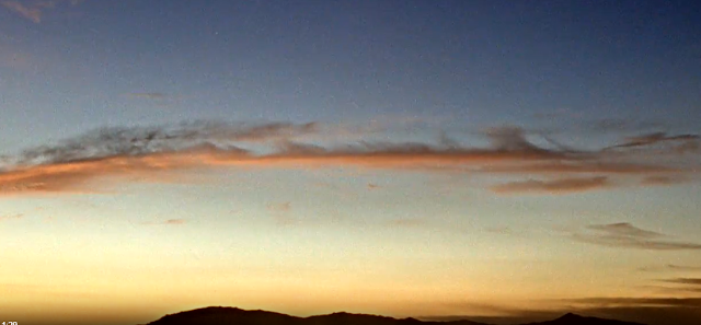
Some sunrise color looking toward Redington Pass at about 6:10 am MST this morning.


The morning 500 mb analysis (above from SPC) shows a chopped up pattern over the Southwest, with a couple of weak shortwaves. The remnants of TS Ileana have apparently dissipated over the southern GoC.


The 12 UTC sounding from TWC/TUS (above, also from SPC) already has over an inch of PW, with considerable CAPE present. Winds are light below 400 mb and steering flow this afternoon would likely be from the west.


Forecast above is from the 06 UTC run of the WRF-GFS and shows PW at midnight tomorrow - note that current values in southeast Arizona are already at these values. Forecast below shows accumulated rainfall - from same model run - through 6:00 am on Tuesday morning. Highest amounts are focused from Santa Cruz and eastern Pima Counties northward toward the Rim area.

Friday, September 13, 2024

Tropical Storm Ileana


Catalinas at 6:50 am MST this morning with perfectly clear skies overhead.


Current 500 mb analysis (above from SPC) shows a large, REX Block over the eastern half of the US that's impeding the eastward progress of the trough over the West.


Over the Eastern Pacific, Tropical Storm Ileana is approaching the south end of Baja with a large shield of very cold cloud - IR image above from 1330 UTC this morning. The current forecast from NHC (below) takes the storm about half way up the GoC before it dissipates.


Forecasts of PW from the 06 UTC GFS run (above valid at midnight last night and below valid at noon tomorrow) show a strong push of moist air into southern Arizona.


Current morning forecast from NWS TUS (below) indicates a wet weekend, although POPs are down a bit from yesterday (see previous post).

Thursday, September 12, 2024

Rainy Weekend Possible


Orange skies again early this morning, looking toward the Rincons.


Plot of detected CG flashes for 24-hours ending at 0733 UTC last night (above from Atmo and Vaisala) indicates a very quiet day yesterday across Arizona, southwestern New Mexico, and northern Mexico.


A trough continues to dominate the West after the demise of the summer monsoon pattern - 500 mb analysis above from SPC.


Weekend outlook for rain amounts (above from NWS TUS) shows south-to-north band of amounts of half to 0ne inch amounts. The 06 UTC WRF-GFS forecast from Atmo (below) shows a more detailed, but similar, forecast for amounts through 6:00 pm MST on Monday. At bottom is current NWS forecast for the airport over the weekend, with 60 to 70 percent POPs on Sunday.

Monday, September 09, 2024

Monsoon Pattern Weakens


Pre-sunrise color looking toward the Rincons this morning a bit before 6:00 am MST.


At 500 mb this morning (above from SPC) there is a weak anticyclone center just east of the Four Corners.


GFS forecasts from 06 UTC (above for 48 hours and below for 96 hours) show the anticyclone weakening as the 500 trough over the West dominates, and the monsoon summer pattern comes to an end. Over the GoM a developing TS is forecast to become a hurricane as it heads toward the lower Mississippi Basin.

Friday, September 06, 2024

Excessive Heat Warning Today


Scattered clouds over the Catalinas at a bit after 5:00 am MST this morning.

There was little to report yesterday, with no CGs over southeastern Arizona and no rainfall reported across the ALERT network. Very dry here, and I'm starting to water some of the plants.


Map above shows NWS warnings and advisories in effect today: Purple shows excessive heat warning areas; orange indicates heat advisories; red regions are under Red Flag warnings for high wildfire threats; and gray areas have air quality advisories in place. Tucson is just within the purple area - note that at airport at 7:00 am this morning temperature was 87 F and winds were gusting over 30 mph.


The morning 500 mb analysis (above from SPC) shows the western anticyclone is elongated from northern Baja northeastward to southern Wyoming. The morning TWC/TUS sounding (below, also from SPC) indicates fairly dry conditions with little CAPE. Winds aloft are westerly to northerly, while winds below 700 mb are southeasterly and fairly strong, so some gusty afternoon winds likely.


Plumes from the 06 UTC GEFS for QPF at the airport (above) indicate a dry week ahead, as does the 06 UTC WRF-GFS forecast from Atmo - below, for period ending at 5:00 am next Friday the 13th of September.

Thursday, September 05, 2024

Hot And Dry


View looking east this morning at 5:50 am MST.


Another totally suppressed day re CG flashes southwest US and northern Mexico - as per CG flashes plot above from Atmo and Vaisala.


At 500 mb this morning (above from SPC) a large anticyclone covers the West. Current forecast from TUS for the airport below - hot and dry, with excessive heat warning today and tomorrow.

Tuesday, September 03, 2024

Summer Overview

Storm over the Catalina foothills on 25 July at 4:00 pm MST.

First, a look at August in detail. Plots above and below show total August rainfall observations across the ALERT network. The driest region covers most of the metro area northwest to Oro Valley. There are three sites that reported over 3 inches of rainfall for the month, and many sites had over 2 inches. Here at the house I measured only 0.78" inches, which was the fifth driest August since 1999.


Back to June - we had 1.75" of rain during the last part of the month. This was the third wettest June here since 1999.

July was another wet month, with a total here of 3.72" - this was the 7th wettest July since 1999 here.

There were 23 days here when I noted that thunderstorms had occurred during the summer (my hearing is bad, so there were probably a few more that I missed). One of these was marginally severe and blew apart our front gate (on 18 July).

Total summer rainfall here was 6.25", which was 10th wettest summer since I started my records. The driest summer was in 2013 (1.51" total), while the wettest here was in 2021 (10.98").

Sunday, September 01, 2024

Light Showers


Pre-sunrise color at about 5:10 am MST looking toward the Rincons this morning, the first day of September.


Plot of detected CG flashes through 1033 UTC last night shows thunderstorms occurred over western parts of eastern Pima County yesterday afternoon.


ALERT observations show widely scattered amounts of 0.04" and more, with most reports on northwest side of the Catalinas. Here at house there was a brief shower that left 0.03" in the gauge. I did not hear any thunder. The airport reported a thunderstorm with gusts to 53 mph and 0.07" of rain; Atmo had 0.02"; while DM did not report any rainfall.


The 500 mb anticyclone (above from SPC) is centered over Colorado this morning, with a hint of an inverted trough to our east. The morning sounding (below, also from SPC) continues to be not very impressive, but with some CAPE above 700 mb. I was wrong about yesterday's sounding and showers here, so I'll just say that I'll be surprised, again, if we have showers here today.


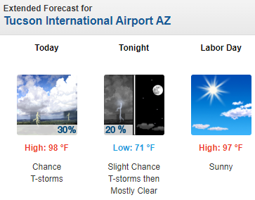
The 12 UTC WRF-HRRR forecast through midnight tonight (above, from Atmo) forecasts little for all of Pima County. Current NWS forecast is shown below.