Sunday, January 24, 2021

Morning Forecasts

Some new snow this morning at Forest Lakes in the Rim Country.

This morning's forecast from NWS Forecast Office - an active three days on tap. Note that the airport is under a winter weather advisory starting tomorrow. The two graphics below are a bit confusing, since one has Tucson in the advisory area and one does not. Consider the above as the current situation.

Morning charts and model forecasts in next post.


Saturday, January 23, 2021

First Significant Storm This Winter


Bit of morning sun hitting campus about 7:40 am MST today. Down at bottom is snow stake in Forest Lakes, Arizona, which is in the Rim Country east of Payson.


GFS forecast (from 00 UTC last evening) above valid at 11:00 am MST tomorrow indicating sharp, 500 mb trough approaching southern Arizona. As this system, and following short wave, impact Arizona, models continue to forecast a significant precipitation event. Plumes below from GEFS are for QPF at the airport. The members indicate measurable precipitation at airport tomorrow and then again Monday morning continuing through the day on Tuesday.
The plumes for temperature at the airport above indicate falling temperatures tomorrow through Wednesday, with drops of 30 F or more - given our fairly mild January to date, this will be a very pronounced turn toward more wintry weather.

In fact, the ensembles forecast a high probability of snow mixed with the rain at the airport (below) Tuesday night into Wednesday morning.


The 06 UTC runs of the WRF-GFS at Atmo are indicating very strong winds at the airport Monday afternoon (above), as second short wave approaches. The same forecast runs indicate light snow accumulations in the far east and south portions of the metro area during Monday night (below), which could bring some hazardous driving conditions, especially on two lane highways such as 83 south toward Sonoita, and 86 west toward Sells, as well as 90 south toward Sierra Vista. Will follow up re these possibilities tomorrow.


Friday, January 22, 2021

Waiting For Next "Event"


Sun breaks through to highlight the University a bit after 5:00 pm MST yesterday. Denver (bottom) had a very fiery sunset yesterday.

Showers yesterday totaled mostly less than a quarter of an inch, except on west side of Tucson Mountains, with much of the main metro area mostly missing out. Couple of sprinkles here but nothing measurable. ALERT (above) and MesoWest (below) observations are for 24-hours ending at 6:00 am this morning.


Now I'll wait for next system and hope for a better outcome here at the house. At 500 mb another closed low is forecast to cross Arizona Sunday (above) with trailing system re-enforcing the Southwest trough by Tuesday (below).


Models (GEFS above, and 00 UTC WRF-GFS below) again forecast a significant precipitation event for Arizona, although amounts were biased considerably too high by last event's forecasts. We'll wait and see how the situation evolves, beginning Sunday. Wouldn't take much to beat the meager 0.05" here so far in January.

The 06 UTC GEFS plumes for temperature are shown second below. Cold Sunday through Tuesday but then a rapid warming rest of week. Looks like another morning here with temperatures down in the 20's Wednesday.


Thursday, January 21, 2021

Overview Of Event So Far


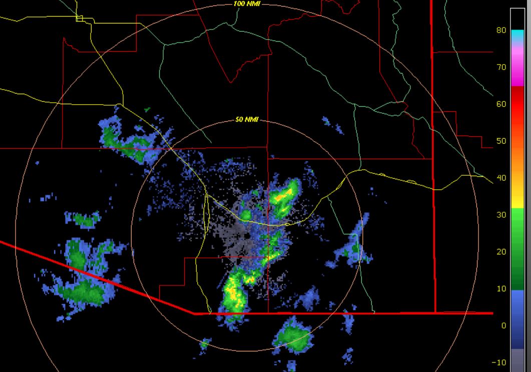
Chaotic skies this morning before sunrise, after light showers that occurred a bit before and after midnight. Here at the house there was rain, but as of now it totaled only 0.05". Barley enough to wet our bone-dry ground. Radar (2nd tilt) from 0635 am MST (below) shows heaviest showers off to our southeast and some light showers/sprinkles out to the west.


Both the 06 UTC plumes for QPF (above) and 06 UTC WRF-GFS precipitation forecast through 6:00 am (below) had amounts for airport that were too large (airport has recorded 0.07"; Atmo had 0.03"). Models indicate that our event is mostly over and that we'll now have to look forward to Sunday and early next week for next rain chances.


Rainfall reports through 6:00 am: ALERT north above; ALERT S below; and metro area (bottom, from MesoWest). Amounts were heaviest to our south and southeast - only one report of half inch (0.51") down near Madera Canyon. All-in-all somewhat of a fizzle given the forecasts of past few days.


Wednesday, January 20, 2021

First Precip Event Of 2021


Another great sunrise here in Tucson.  Our first precipitation event of 2021 is imminent and much anticipated, since there has only been 0.01" of rain here at house since December 11th.

Happened to catch a view of a BurlingtonNorthernSantaFe train clipping through Flagstaff this morning (bottom).

Time series of TUS observations above shows dewpoint temperature rising slowly, but steadily since the strange blip yesterday (reasons for that not clear). The east-southeast winds have been quite gusty all night at the airport, with a max of 40 mph a bit before midnight.

Yuma has had a thunderstorm during the night and now has about 0.40" of rainfall. Plot of detected CG flashes for about the last 6 hours (below, from Atmo and Vaisala) shows quite a bit of activity north end GoC into southwest Arizona, and also with the closed low west of Baja.


The 500 mb low (above) has moved about as forecast yesterday and is currently well southwest of San Diego. The 1430 UTC GeoColor image below (from CIRA at Colorado State) shows considerable middle and high clouds (gray shades) from the low across Baja and into western Arizona and California deserts. The blue shades are low clouds and the orange areas are the city lights of Arizona and California.

Model forecasts from the GEFS (above) continue to call for a significant rain event to begin at the airport later today and extend into tomorrow morning. Forecast amounts today are a bit lower than they were yesterday. The morning forecast for the airport - below from NWS - indicates 100 percent POPS, as well as heavy rain amounts, tonight into tomorrow morning.

Second below is forecast rain amounts from the 12 UTC WRF-RR run this morning - WRF amounts are down by around an inch relative to yesterday. Note that the WRF picks up the ominous Tucson donut hole, probably due to downslope, low-level winds. 

Regardless, I look forward to seeing what the gauge out in our yard catches!


Tuesday, January 19, 2021

Rain Event Still On Track


Partly cloudy with some color at 8:00 am MST this morning. 

Today we will see increasing clouds and also some gusty winds from the east to southeast. Forecast above from the 06 UTC run of the WRF-GFS at Atmo shows 10-m winds at noon today. Forecast for temperature at the airport from the 06 UTC GEFS ensemble system (below) indicates this is our last really mild day, and we'll see cooling for rest of week


At 500 mb this morning a strong, closed low is centered over Nevada (above), with very strong winds over 100 kt on northwest side of the low. The 250 mb chart for same time (below) shows strong north-northeast jet from Montana to central California coast. This jet will pull the low southwestward to be off of Baja tomorrow. The low is forecast to go far enough west to allow it to pick up subtropical moisture and bring it into Arizona, setting the stage for a significant precipitation event.


Forecast above (also from 06 UTC WRF-GFS) is for composite radar echoes valid at 9:00 pm tomorrow night - large area of rain indicated for Pima County and also strong echoes, perhaps thunderstorms, out around Yuma. Forecast totals for precipitation through midnight on Thursday night (below) are impressive, as are the QPF plumes from the 06 UTC GEFS (bottom). Many to most of the model runs are forecasting over an inch of rain at the airport. If all this is reasonably accurate, we're looking at the best rains here at low elevations in many months!


Monday, January 18, 2021

Rain Still likely Latter This Week


Brilliant blues skies over the Catalinas again, this morning of the Martin Luther King Holiday. However, model forecasts continue to indicate that there will be a good chance for a rainy end of the week.

Second image from bottom shows a pink sunrise on this past Saturday morning.

I have been alerted by Morris Webb, of Albuquerque, that the image at bottom does NOT show the lights of Los Angeles, as I have often stated. Rather the view from Mt. Hamilton is of the lights of San Jose and San Francisco at the north end of the Santa Clara Valley. Thanks to Morris for his message


A short wave at 500 mb, current offshore west of California, closes off west of Baja and then brings us several wet days as it inches eastward across Arizona, while opening up. The 500 mb GFS forecast above is valid 06 UTC on the 21st, at the start of the rainy period. Forecasts of QPF from the 06 UTC GEFS ensemble members are shown below. 

The forecasts are consistent, all indicating rain chances from the 20th through the 26th; however, total amounts are all over the place, ranging from 0.10" to almost 2.50". The amounts of the average (black) and the operational GFS (blue) would bring a very welcome end to our long dry spell.