
 The current synoptic situation is fairly complex as a mid-level trof over California interacts with a weak lobe of the eastern anticyclone that is broken off over northern New Mexico. At higher levels, an unusually strong trough continues over most of the western US.
----------------------------------------------------------
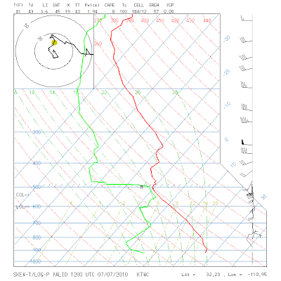
Top graphic is this morning's (7 Jul 2010) Tucson (TWC) sounding. The sounding's PW and GPS PW are quite close and indicate PW of about 20 mm (values over much of Arizona are in the range of 20 to 25 mm this morning). The sounding is fairly similar to soundings about a week ago. There is cool air aloft from 500 to around 400 mb, above a very deep residual boundary layer, providing a layer with CAPE from around 600 mb to 400 mb, with warm air above in the upper-troposphere. Thus, a good sounding for high-based convection and possible dry downbursts. CAPE will be better over high elevations, but it is not obvious whether it will be large enough to overcome the very warm air aloft around 300 mb. It does appear that the southern Arizona boundary layer will continue to moisten gradually, via evaporation of virga and precipitation, coupled with moist outflows from convective storms over higher terrain.
--------------------------------------------------------
This morning's NAM 500 mb analysis (middle panel) indicates the trough over California and the wind field indicates the small anticyclone over northern New Mexico. These two features are interacting to produce the southerly, mid-level flow pattern. The model forecasts the California trough to retreat westward during the next couple of days as the larger, eastern anticyclone builds westward.
---------------------------------------------------------
The bottom panel shows the morning RUC analysis for 250 mb - quite a strong trough over the West and an ugly, strong westerly jetstream, off the Pacific, crossing southern California, Arizona and New Mexico.
---------------------------------------------------------
Last evening's operational GFS forecasts a nice precipitation event over southeastern Arizona for the 24-hours ending 5 pm on Sunday (11 July). The model forecasts amounts as high as a 1/4 to 1/2 an inch over lower elevations. The apparent driver for this forecast event is an inverted trough that the model forecasts (at 700 mb) be over the south Texas coast at 48 hours; just west of the Texas Big Bend Country at 96 hours; and much weakened but over southeast Arizona at 108 hours. So, we will have to watch how this feature materializes and advances during the next several days.
No comments:
Post a Comment